
Southeast Alaska, often abbreviated to southeast or southeastern, and sometimes called the Alaska(n) panhandle, is the southeastern portion of the U.S. state of Alaska, bordered to the east and north by the northern half of the Canadian province of British Columbia. The majority of southeast Alaska is situated in Tlingit Aaní, much of which is part of the Tongass National Forest, the United States' largest national forest. In many places, the international border runs along the crest of the Boundary Ranges of the Coast Mountains. The region is noted for its scenery and mild, rainy climate.

Sitka is a unified city-borough in the southeast portion of the U.S. state of Alaska. It was under Russian rule from 1799 to 1867. The city is situated on the west side of Baranof Island and the south half of Chichagof Island in the Alexander Archipelago of the Pacific Ocean. As of the 2020 census, Sitka had a population of 8,458, making it the fifth-most populated city in the state.

Pelican is a small town in the northwestern part of Chichagof Island in Hoonah-Angoon Census Area in the U.S. state of Alaska. As of the 2010 census, the population of the city was 88, down from 163 at the 2000 census. As of the newest 2020 census, Pelican has a total population of 98 people.

Wrangell is a borough in Alaska, United States. As of the 2020 census the population was 2,127, down from 2,369 in 2010.

The Catawba River is a major river located in the Southeastern United States. It originates in Western North Carolina and flows into South Carolina, where it later becomes known as the Wateree River. The river is approximately 220 miles (350 km) long. It rises in the Appalachian Mountains and drains into the Piedmont, where it has been impounded through a series of reservoirs for flood control and generation of hydroelectricity. The river is named after the Catawba tribe of Native Americans, which lives on its banks. In their language, they call themselves "yeh is-WAH h’reh", meaning "people of the river."

The Stikine River is a major river in northern British Columbia (BC), Canada and southeastern Alaska in the United States. It drains a large, remote upland area known as the Stikine Country east of the Coast Mountains. Flowing west and south for 610 kilometres (379 mi), it empties into various straits of the Inside Passage near Wrangell, Alaska. About 90 percent of the river's length and 95 percent of its drainage basin are in Canada. Considered one of the last truly wild large rivers in BC, the Stikine flows through a variety of landscapes including boreal forest, steep canyons and wide glacial valleys.

Lake of the Ozarks is a reservoir created by impounding the Osage River in the northern part of the Ozarks in central Missouri. Parts of three smaller tributaries to the Osage are included in the impoundment: the Niangua River, Grandglaize Creek, and Gravois Creek. The lake has a surface area of 54,000 acres (220 km2) and 1,150 miles (1,850 km) of shoreline. The main channel of the Osage Arm stretches 92 miles (148 km) from one end to the other. The total drainage area is over 14,000 square miles (36,000 km2). The lake's serpentine shape has earned it the nickname "the Missouri Dragon", which has, in turn, inspired the names of local institutions such as the Magic Dragon Street Meet.
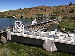
The Link River Dam is a concrete gravity dam on the Link River in the city of Klamath Falls, Oregon, United States. It was built in 1921 by the California Oregon Power Company (COPCO), the predecessor of PacifiCorp, which continues to operate the dam. The dam is owned by the U.S. Bureau of Reclamation.

The Bull Run River is a 21.9-mile (35.2 km) tributary of the Sandy River in the U.S. state of Oregon. Beginning at the lower end of Bull Run Lake in the Cascade Range, it flows generally west through the Bull Run Watershed Management Unit (BRWMU), a restricted area meant to protect the river and its tributaries from contamination. The river, impounded by two artificial storage reservoirs as well as the lake, is the primary source of drinking water for the city of Portland, Oregon.

MV Fairweather is a catamaran ferry built by Derecktor Shipyards in Bridgeport, Connecticut for the Alaska Marine Highway System entering service 2004. After being laid up since 2019, in March 2021 it was sold to Servicios y Concesiones Maritimas Ibicencas for service between Mallorca and Menorca.
The Eklutna River is approximately 11.8 miles (19.0 km) long and is located in the Southcentral region of the U.S. state of Alaska. A portion of the river flows through a canyon up to 400 feet (120 m) deep, emptying into the Knik Arm of Cook Inlet approximately 17 miles (27 km) northeast of Anchorage. This degraded anadromous stream historically originated from Eklutna Lake, which itself is fed by Eklutna Glacier. Eklutna River is now fed primarily by groundwater before being joined by Thunderbird Creek. Thunderbird Creek, which enters the south bank about 1 km (0.62 mi) upstream from where the river exits the canyon and forms an alluvial fan. Due to water impoundments on the Eklutna River for power generation, Thunderbird Creek is currently the main source of water in the lower portion of the Eklutna River. The river is located entirely within the limits of the Municipality of Anchorage.
Silver Bay, or Gaǥeit', in the Tlingit language, is a deep water fjord located southeast of Sitka, Alaska, United States, that indents Baranof Island. It was named through a United States Coast and Geodetic Survey translation of Bukhta Serebryanikova, a name published first by Captain Tebenkov of the Imperial Russian Navy in 1852.
Green Lake is a lake/reservoir south of Sitka, Alaska. It is fed by the Vodopad River and outflows into Silver Bay.

Croton Dam is an earth-filled embankment dam and powerplant complex on the Muskegon River in Croton Township, Newaygo County, Michigan. It was built in 1907 under the direction of William D. Fargo by the Grand Rapids - Muskegon Power Company, a predecessor of Consumers Energy. The 40-foot-high (12 m) dam impounds 7.2 billion U.S. gallons (6 billion imp. gal/27 billion L) of water in its 1,209-acre (489 ha) reservoir and is capable of producing 8,850 kilowatts at peak outflow. It was listed on the National Register of Historic Places in 1979.

Cropley Lake is an alpine lake in the Juneau, Alaska, United States. Located on Douglas Island, it is 2 miles (3.2 km) southwest of Table Top Mountain, and 5 miles (8.0 km) southwest of the city of Juneau. Cropley Lake is the source of Fish Creek.

The Salmon Creek Dam is a concrete arch dam on the Salmon Creek, 3 miles (5 km) northwest of Juneau, Alaska. Built in 1914, it is the world's first constant-angle arch variable radius dam. Since it was built, over 100 such dams have been constructed all over the world. The dam was designated as a National Historic Civil Engineering Landmark by the American Society of Civil Engineers in 2022.

Baranof Island is an island in the northern Alexander Archipelago in the Alaska Panhandle, in Alaska. The name "Baranof" was given to the island in 1805 by Imperial Russian Navy captain U. F. Lisianski in honor of Alexander Andreyevich Baranov. It was called Sheet’-ká X'áat'l by the native Tlingit people. It is the smallest of the ABC islands of Alaska. The indigenous group native to the island, the Tlingit, named the island Shee Atika. Baranof island is home to a diverse ecosystem, which made it a prime location for the fur trading company, the Russian American Company. The Russian occupation of Baranof Island impacted not only the indigenous population and the ecology of the island, but also led to the United States' current ownership over the land.

Ripogenus Gorge is a rock-walled canyon formed in Maine where the West Branch Penobscot River crosses the Caribou Lake anticline. Ripogenus Falls controlled discharge from Ripogenus Lake until Ripogenus Dam was completed at the upstream end of the gorge in 1916. The dam forms a hydroelectric reservoir raising the level of Ripogenus Lake to include the upstream Chesuncook Lake, Caribou Lake, and Moose Pond. The resulting reservoir is often identified by the name of the largest included lake: Chesuncook. The gorge provides an unusual exposure of Maine North Woods bedrock typically covered by saturated glacial till. The Silurian Ripogenus Formation of weakly metamorphosed shallow marine siliciclastics and fossiliferous limestone has been described from investigation of the gorge.

The Eklutna Dam, also referred to as the New Eklutna Dam or Upper Eklutna Dam, is an embankment dam on the Eklutna River about 30 mi (48 km) northeast of Anchorage in Alaska, United States. The primary purpose of the dam is hydroelectric power generation and it supports a 47 MW power plant. It was first completed in 1929 but was rehabilitated or rebuilt on several occasions over its history. Ownership of the dam and power plant is shared by Chugach Electric and Matanuska Electric.
The Sitka Pulp Mill was a pulp mill located on the North and West Shores of Sawmill Cove, approximately five miles East of Sitka, Alaska. In 1956, the mill site was purchased from Freda and John Van Horn by the Alaska Pulp Corporation. This was the first Japanese investment in the United States of America since World War II, and the mill operated from 1959 until 1993. The majority of production was used to create rayon fabric, and to supply Japan with logs to rebuild homes and infrastructure after World War II. In the later years of the mill, as the demand for rayon and logs for rebuilding decreased, the primary focus of the mill became the manufacture of paper.


