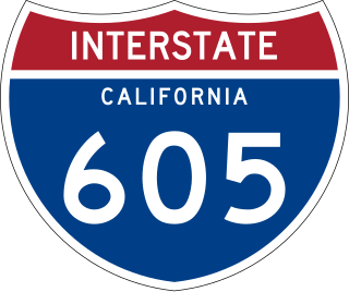
Interstate 605 is a 27-mile-long (43 km) major north–south auxiliary Interstate Highway in the Greater Los Angeles urban area of Southern California. It runs from I-405 and State Route 22 (SR 22) in Seal Beach to I-210 in Duarte. The San Gabriel River Freeway closely parallels the San Gabriel River for most of its alignment, hence its name, which is one of the few Southern California freeways not named after a city along its route.
An environmental impact statement (EIS), under United States environmental law, is a document required by the 1969 National Environmental Policy Act (NEPA) for certain actions "significantly affecting the quality of the human environment". An EIS is a tool for decision making. It describes the positive and negative environmental effects of a proposed action, and it usually also lists one or more alternative actions that may be chosen instead of the action described in the EIS. One of the primary authors of the act is Lynton K. Caldwell.

Interstate 3 (I-3), the 3rd Infantry Division Highway, is a proposed Interstate Highway in the United States to run from Savannah, Georgia, north to Augusta, Georgia, and Knoxville, Tennessee. The roadway was proposed in the same federal highway measure that gave birth to a proposal for I-14.

Route 37 is a state highway running 3.47 miles (5.58 km) in Providence County and Kent County, Rhode Island, United States. A freeway for its entire length, it serves the cities of Cranston and Warwick and is also a major east–west freeway in the Providence metropolitan area, linking T. F. Green Airport with Interstate 295. The western terminus of Route 37 is an at-grade intersection with Natick Avenue in Cranston. The freeway has numbered interchanges with I-295, Rhode Island Route 2, Pontiac Avenue, and I-95 before terminating at a trumpet interchange with U.S. Route 1 in Warwick.

Interstate 170 (I-170) was the designation for a 2.3-mile (3.7 km) freeway in Baltimore, Maryland, that currently carries U.S. Route 40 (US 40). The freeway was originally planned to be the eastern terminus of I-70 and, later, a link between I-70 and the west side of Downtown Baltimore. However, after the Baltimore portion of I-70 was canceled due to community opposition, the freeway was left disconnected from the Interstate system and its Interstate designation rescinded. Local citizens and environmental groups have given the freeway nicknames of "The Highway to Nowhere" and "The Ditch", the latter owing to its mostly below-grade construction; other names include the "Westside Freeway" and the "Franklin–Mulberry Expressway", both referring to its location in the city. Growing support for the freeway's removal has occurred over the last several years.

Interstate 605 (I-605) is the popular moniker given to several proposals for a new auxiliary Interstate Highway bypassing I-5 and I-405 in the U.S. state of Washington. Proposals have been heard from since the 1960s, including highways connecting from I-5 all the way to the Canada–US border, and some just between I-5 and I-90. The Washington State Department of Transportation (WSDOT) has no projects designated I-605 at this time. However, some I-605 proposals have included State Route 18, which has been partially constructed as a freeway.
The CANAMEX corridor is a series of improvements to freeways and other transportation infrastructure linking Canada to Mexico through the United States. The corridor was established under the North American Free Trade Agreement. Currently the corridor is defined by a series of highways. However, the corridor is also proposed for use by railroads and fiber optic telecommunications infrastructure.

State Highway 16 is a south–north state highway in the U.S. state of Texas that runs from Zapata on the boundary with Mexico to U.S. Highway 281 24 miles (39 km) south of Wichita Falls. It is the longest state highway in Texas at almost 542 miles (872 km), but is only the ninth-longest of any highway classification in the state.

Interstate 40 (I-40) is a major east–west Interstate Highway in the United States, stretching from Barstow, California, to Wilmington, North Carolina. The segment of I-40 in California is sometimes called the Needles Freeway. It passes through the eastern fringe of the Inland Empire metropolitan area, going east from its western terminus at I-15 in Barstow across the Mojave Desert in San Bernardino County past the Clipper Mountains to Needles, before it crosses over the Colorado River into Arizona east of Needles. All 155 miles (249 km) of I-40 in California are in San Bernardino County.
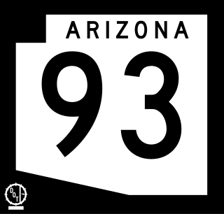
Arizona State Route 93, abbreviated SR 93, was a state highway in Arizona that existed from 1946 to 1991. The route was co-signed with other highways along nearly all of its route from Kingman to the border at Nogales. SR 93 was the original designation for the highway from Kingman to Wickenburg, which was built in 1946. In 1965, the northern terminus of the state route was moved south to an unnamed desert junction with U.S. Route 89 just north of Wickenburg, and the southern terminus of U.S. Route 93 was moved south to the US 89 junction. The Arizona Highway Department sought U.S. Highway status for SR 93 across the rest of the state, but the proposal was never granted by AASHTO. On December 17, 1984, the SR 93 designation was removed south of the Grand Avenue/Van Buren Street/7th Avenue intersection in Phoenix. The route was completely decommissioned in 1991.
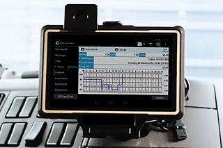
An electronic on-board recorder (EOBR) is an electronic device attached to a commercial motor vehicle, which is used to record the amount of time a vehicle is being driven. This is similar to the tachograph, and is the American equivalent of the digital tachograph used in Europe. Trucks in the European Union are required to have digital tachographs installed, and are securely monitored by government agencies. However, in Europe, the new digital tachograph which is considered secure, can be tricked with a round magnet placed by drivers over the connection to the transmission box. Usually they tie a rope to that magnet, and with a simple pull, the magnet will disengage and will show that the driver started moving about half an hour ago . The majority of carriers and drivers in the United States currently use paper-based log books. On January 31, 2011, the U.S. Federal Motor Carrier Safety Administration (FMCSA) proposed a rule requiring Electronic On-Board Recorders for interstate commercial truck and bus companies. The proposed rule covers interstate carriers that currently use log books to record driver's hours of service. The proposal would affect more than 500,000 carriers in the United States and carriers that currently use time cards would be exempt.
Highway revolts have occurred in cities and regions across the United States. In many cities, there remain unused highways, abruptly terminating freeway alignments, and short stretches of freeway in the middle of nowhere, all of which are evidence of larger projects which were never completed. In some instances, freeway revolts have led to the eventual removal or relocation of freeways that had been built.
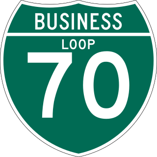
Business routes of Interstate 70 (I-70) exist in three states, though historically they have existed in five. Utah and Missouri each have three existing I-70 business routes. Business routes in Kansas have either been proposed and rejected or decommissioned. Another 13 I-70 business routes also exist in Colorado and four others have also existed in the past, leading to a grand total of 17 within the Centennial State.