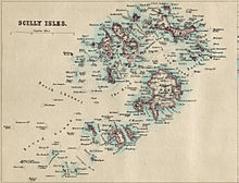
This is a list of the islands in the Isles of Scilly. [1]
This is a list of the islands in the Isles of Scilly. [1]
There are five inhabited islands of the Isles of Scilly, Cornwall, United Kingdom (six if you count the tidal island of Gugh which is separated from St. Agnes at high tide).
| Name | Image | Coordinates | Population | Area (hectares) | Elevation (metres) |
|---|---|---|---|---|---|
| Bryher |  | SV876361 | 83 | 122 | 42 |
| Gugh |  | [2] | 3 | 50 | 34 |
| St Agnes |  | SV881430 | 73 | 366 | |
| St Martin's |  | 925 159 SV 925 159 | 142 | 237 | 47 |
| St Mary's |  | SV915115 | 1723 [3] (2011) | 629 | 51 |
| Tresco | 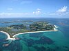 | SV894147 | 175 (2011) | 297 | 44 |

The following islands lie in the civil parish of Bryher, and include the group of Norrard Rocks which were designated as a Site of Special Scientific Interest in 1971. The only inhabited island in this area is Bryher itself.
| Name | Image | Coordinates | Area (hectares) |
|---|---|---|---|
| Castle Bryher |  | SV863140 | 0.39 |
| Gweal |  | [4] SV866152 | 5.82 |
| Illiswilgig |  | SV858139 | 0.9 |
| Maiden Bower |  | [5] SV850145 | 0.66 |
| Mincarlo |  | [6] SV853129 | 1.82 |
| Scilly Rock |  | SV859156 | 1.98 |
| Seal Rock |  | [7] SV854141 | 0.2 |
| Zantman's Rock | 0.02 |

The following islands lie in the civil parish of St. Agnes, and include the group of Western Rocks. The only inhabited islands in this area are St Agnes and Gugh.
| Name | Image | Coordinates | Area (hectares) |
|---|---|---|---|
| Annet |  | 21 | |
| Biggal of Gorregan |  | [8] | |
| Burnt Island |  | [9] | |
| Daisy | [10] SV839053 | 0.57 | |
| Gilstone |  | [9] SV832053 | |
| Gorregan |  | [11] | 1.57 |
| Great Crebawethan |  | [12] SV830071 | 0.51 |
| Hellweathers |  | [13] | |
| Jacky's Rock | | ||
| Little Crebawethan | | [14] SV827069 | 0.14 |
| Melledgan |  | [15] | 0.96 |
| Retarrier Ledges | [16] SV820059 | ||
| Rosevean |  | [17] SV839056 | 0.63 |
| Rosevear |  | 4 | |
| The Brow | [18] |

The following islands lie in the civil parish of St. Martin's, and include the group of Eastern Isles. The only inhabited island in this area is St Martin's itself.
| Name | Image | Coordinates | Area (hectares) |
|---|---|---|---|
| Eastern Isles |  | , SV939149 | |
| Great Arthur |  | [19] | |
| Great Ganilly |  | [20] | 13 |
| Great Ganinick |  | [21] | |
| Great Innisvouls |  | ||
| Guther's Island | | [22] | |
| Hanjague |  | [23] SV957150 | |
| Little Ganilly |  | [24] | |
| Little Ganinick | [25] | ||
| Little Innisvouls |  | SV955142 | |
| Menawethan |  | SV954137 | |
| Moths Ledge |  | 9205 1516 SV 9205 1516 | |
| Nornour |  | SV944148 | |
| Ragged Island |  | SV946138 | |
| White Island |  | [26] | 15 |

The civil parish of St. Mary's contains the island of St Mary's itself which includes a few tidal islands which are connected at low tide.
| Name | Image | Coordinates | Area (hectares) |
|---|---|---|---|
| Newford Island |  | ||
| Taylor's Island |  | [27] | |
| Toll's Island |  | [28] |

The following islands lie in the civil parish of Tresco. The only inhabited island in this area is Tresco itself.
| Name | Image | Coordinates | Area (hectares) |
|---|---|---|---|
| Broad Ledge |  | [29] | |
| Green Island | | ||
| Hedge Rock |  | ||
| Mare Ledges |  | ||
| Northwethel |  | [30] SV895163 | 4.63 |
| Old Man |  | ||
| Pednbrose |  | [31] | |
| Round Island | | [32] | 1.2 |
| Samson |  | [33] | 38 |
| St Helen's |  | 20 | |
| Stony Island |  | [34] | |
| Teän |  | [35] | 16 |
| Tobaccoman's Ledge | [36] |

Tresco is the second-biggest island of the Isles of Scilly. It is 297 ha (1.15 sq mi) in area, measuring about 3.5 km (2.2 mi) by 1.75 km (1.09 mi).

St Agnes is the southernmost populated island of the Isles of Scilly. Thus the island's Troy Town Farm is the southernmost settlement in the United Kingdom.

Bryher is one of the smallest inhabited islands of the Isles of Scilly, with a population of 84 in 2011, spread across 134 hectares (1.34 km2). Bryher exhibits a procession of prominent hills connected by low-lying necks and sandy bars. Landmarks include Hell Bay, famous for shipwrecks in the 18th and 19th centuries, Shipman Head, which was fortified in the Iron Age and where the tumbled ramparts of an Iron Age castle remain, and All Saints' Church, originally constructed in 1742. The island has two quays, Church Quay and Bar Quay.

Gugh could be described as the sixth inhabited island of the Isles of Scilly, but is usually included with St Agnes with which it is joined by a sandy tombolo known as "The Bar" when exposed at low tide. The island is only about 1 km (0.62 mi) long and about 0.5 km (0.31 mi) wide, with the highest point, Kittern Hill, at 34 m (112 ft). The geology consists of Hercynian granite with shallow podzolic soils on the higher ground and deeper sandy soils on the lower ground. The former Gugh farm is just north of the neck across the middle of the island between the two hills. The two houses were designed and built in the 1920s by Charles Hamlet Cooper.
The Council of the Isles of Scilly is a sui generis local government authority covering the Isles of Scilly off the west coast of Cornwall, England. It is currently made up of 16 seats, with all councillors being independents. The council was created in 1891 as the Isles of Scilly Rural District Council and was renamed in 1974.
RMV Scillonian was a passenger ferry built for the Isles of Scilly Steamship Company in 1925 by the Ailsa Shipbuilding Company Ltd of Troon, Scotland. She was designed to carry 400 passengers and cargo between Penzance, Cornwall, UK, to the offshore Isles of Scilly.
The Isles of Scilly are a small archipelago off the southwestern tip of Cornwall, England, United Kingdom. One of the islands, St Agnes, is over four miles further south than the most southerly point of the British mainland at Lizard Point, and has the southernmost inhabited settlement in England, Troy Town.

St Nicholas's Church, Tresco, is a parish church in the Church of England located in Tresco, Isles of Scilly, UK.

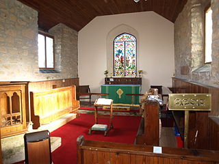
All Saints' Church is a Grade II listed parish church in the Church of England located in Bryher, Isles of Scilly.
St Martin's Church, St Martin's is a Grade II listed parish church in the Church of England located in St Martin's, Isles of Scilly, UK.

St Mary's Church, St Mary's is a parish church in the Church of England located in Hugh Town, St Mary's, Isles of Scilly, UK. The Church was consecrated on 7 September 1838 and replaced the church at Old Town which was inconvenient for the Hugh Town population and in need of repair.

St Mary's Old Church, St Mary's is a parish church in the Church of England located in Old Town on St Mary's, Isles of Scilly, Cornwall, United Kingdom.
Elections to the Council of the Isles of Scilly, a sui generis unitary authority in the far southwest of England, were held on 4 June 2009.
The 2013 Council of the Isles of Scilly election took place on 2 May 2013 as part of the 2013 local elections in the United Kingdom The council is a sui generis unitary authority within the ceremonial county of Cornwall.
The Isles of Scilly are an archipelago 45 km (28 mi) off Land's End, Cornwall. Little of the fauna on, above or in the seas surrounding the isles was described prior to the 19th century, when birds and fish started to be described. Most records of other animals date from the 20th century onwards.

The 2017 Council of the Isles of Scilly election took place on 4 May 2017 as part of the 2017 local elections in the United Kingdom. The council is a sui generis unitary authority within the ceremonial county of Cornwall.
Elections to the Council of the Isles of Scilly took place on 6 May 2021, alongside other United Kingdom local elections. All 16 seats on the council were up for election. There are 12 councillors for St Mary's and 1 each of the other inhabited isles of Bryher, St Agnes, St Martin's and Tresco.
Elections to the Council of the Isles of Scilly will take place on 1 May 2025, alongside other United Kingdom local elections. All 16 seats on the council will be up for election. There are 12 councillors for St Mary's and 1 each of the other inhabited isles of Bryher, St Agnes, St Martin's and Tresco.
| Inhabited islands | 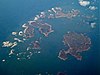 | |
|---|---|---|
| Uninhabited islands | ||
| Settlements |
| |
| Lighthouses | ||
| Symbols | ||
| Topics | ||