This an alphabetical list of lakes in Lake County, California includes lakes, ponds, and reservoirs. Numbers in parentheses are Geographic Names Information System feature ids.

A lake is an area filled with water, localized in a basin, surrounded by land, apart from any river or other outlet that serves to feed or drain the lake. Lakes lie on land and are not part of the ocean, and therefore are distinct from lagoons, and are also larger and deeper than ponds, though there are no official or scientific definitions. Lakes can be contrasted with rivers or streams, which are usually flowing. Most lakes are fed and drained by rivers and streams.
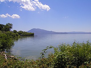
Lake County is a county located in the north central portion of the U.S. state of California. As of the 2010 census, the population was 64,665. The county seat is Lakeport. The county takes its name from Clear Lake, the dominant geographic feature in the county and the largest natural lake wholly within California.
The Geographic Names Information System (GNIS) is a database that contains name and locative information about more than two million physical and cultural features located throughout the United States of America and its territories. It is a type of gazetteer. GNIS was developed by the United States Geological Survey in cooperation with the United States Board on Geographic Names (BGN) to promote the standardization of feature names.


- Adobe Reservoir (1657212)
- Amel Lake (218225)
- Blue Lakes (219501)
- Blue Slides Lake (257282)
- Boggs Lake (219585)
- Borax Lake (219659)
- Lake Bordeaux (1657217)
- Burger Lake (220182)
- Lake Burgundy (1657218)
- Catfish Pond (258076)
- Clear Lake (258441, 1664234)
- Detert Reservoir (253211)
- Dry Lake (222650)
- Eachus Lake (222797)
- Hidden Lake (225245)
- Hidden Valley Lake (1657219, 1663861)
- Highland Springs Reservoir (1657213)
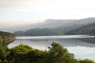
- Indian Valley Reservoir (274690)
- Lakeport Lake (252102)
- Little Borax Lake (262549)
- Lower Blue Lake (234205)
- Lower Bohn Lake (234206)
- McCreary Lake (253232)
- Ora Lake (230069)
- Pinkeye Lake (230738)
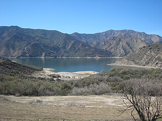
- Lake Pillsbury (234468)
- Rocky Lake (231775)
- Snows Lake (234785)
- Stienhart Lakes (235478)
- Summit Lake (235750)
- Thurston Lake (236335)
- Timber Lake (268286)
- Tule Lake (236601)
- Tule Lake (236603)
- Upper Bohn Lake (253239)
- Wildcat Lake (237797)
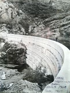
Adobe Reservoir is the smaller of two adjacent reservoirs in Lake County, California the other being Highland Springs Reservoir. The reservoir is fed by Adobe Creek and does contain fish, although a recent survey by the California Department of Fish and Wildlife were unable to identify the species. However, California roach specimens were collected upstream from Adobe Reservoir in Adobe Creek.
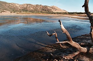
The Borax Lake Site, also known as the Borax Lake—Hodges Archaeological Site and designated by the Smithsonian trinomial CA-LAK-36, is a prehistoric archaeological site near Clearlake, California. The site, a deeply stratified former lakeshore, contains evidence of the earliest known period of human habitation in what is now California, dating back 12,000 years. A portion of the site, designated a National Historic Landmark in 2006, is owned and preserved by the Archaeological Conservancy.
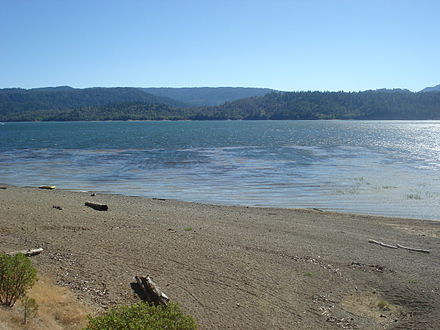
Clear Lake is a natural freshwater lake in Lake County in the U.S. state of California, north of Napa County and San Francisco. It is the largest natural freshwater lake wholly within the state, with 68 square miles (180 km2) of surface area. At 480,000 years, it is the oldest lake in North America. It is the latest lake to occupy a site with a history of lakes stretching back at least 2,500,000 years.