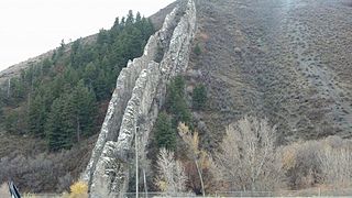
Morgan County is a county in northern Utah, United States. As of the 2020 census, the population was 12,295. Its county seat and largest city is Morgan. Morgan County is part of the Ogden-Clearfield, UT Metropolitan Statistical Area as well as the Salt Lake City-Provo-Orem, UT Combined Statistical Area.
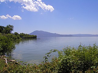
Lake County is a county located in the north central portion of the U.S. state of California. As of the 2020 census, the population was 68,163. The county seat is Lakeport. The county takes its name from Clear Lake, the dominant geographic feature in the county and the largest non-extinct natural lake wholly within California.

Thurston County is a county located in the U.S. state of Washington. As of the 2020 census, its population was 294,793. The county seat and largest city is Olympia, the state capital.

Crater Lake is a volcanic crater lake in south-central Oregon in the Western United States. It is the main feature of Crater Lake National Park and is famous for its deep blue color and water clarity. The lake partly fills a 2,148-foot-deep (655 m) caldera that was formed around 7,700 years ago by the collapse of the volcano Mount Mazama. No rivers flow into or out of the lake; the evaporation is compensated for by rain and snowfall at a rate such that the total amount of water is replaced every 250 years. With a depth of 1,949 feet (594 m), the lake is the deepest in the United States. In the world, it ranks tenth for maximum depth, as well as third for mean (average) depth.

Kīlauea is an active shield volcano in the Hawaiian Islands. Located along the southeastern shore of Hawai'i Island, the volcano is between 210,000 and 280,000 years old and emerged above sea level about 100,000 years ago. Historically, it is the most active of the five volcanoes that together form the island of Hawaii. Kīlauea is also one of the most active volcanoes on Earth, with the most recent eruption occurring for a week in September 2023 when multiple vents erupted lava within the volcano's summit caldera inside Halemaʻumaʻu crater.

Hawaiʻi Volcanoes National Park is an American national park located in the U.S. state of Hawaii on the island of Hawaii. The park encompasses two active volcanoes: Kīlauea, one of the world's most active volcanoes, and Mauna Loa, the world's largest shield volcano. The park provides scientists with insight into the development of the Hawaiian Islands and access for studies of volcanism. For visitors, the park offers dramatic volcanic landscapes, glimpses of rare flora and fauna, and a view into the traditional Hawaiian culture connected to these landscapes.

Thurston Island is an ice-covered, glacially dissected island, 215 km (134 mi) long, 90 km (56 mi) wide and 15,700 km2 (6,062 sq mi) in area, lying a short way off the northwest end of Ellsworth Land, Antarctica. It is the third-largest island of Antarctica, after Alexander Island and Berkner Island.

Houston, the most populous city in the Southern United States, is located along the upper Texas Gulf Coast, approximately 50 miles (80 km) northwest of the Gulf of Mexico at Galveston. The city, which is the ninth-largest in the United States by area, covers 601.7 square miles (1,558 km2), of which 579.4 square miles (1,501 km2), or 96.3%, is land and 22.3 square miles (58 km2), or 3.7%, is water.

State Route 510 (SR 510) is a state highway in Thurston County, Washington. The 13 miles (20.9 km) long highway extends southeast from an interchange with Interstate 5 (I-5) in Lacey to SR 507 in Yelm. SR 510 roughly parallels the Nisqually River, the border between Thurston and Pierce counties, between the Fort Lewis and Nisqually Indian Community area to Yelm.

Mary Jane Thurston State Park is a 105-acre (42 ha) public recreation area one mile west of Grand Rapids in Wood and Henry counties, Ohio, United States. The state park lies along the south bank of the Maumee River near remains of the historic Miami and Erie Canal. It is named for Mary Jane Thurston, a schoolteacher from Grand Rapids who bequeathed land for the establishment of a park. The park's year-round recreation includes hunting, fishing, boating, picnicking, and camping.
Bellisime Glacier is a glacier about 4 nautical miles (7 km) long flowing south from Thurston Island east of Myers Glacier. It was named by the Advisory Committee on Antarctic Names after Lynda B. Bellisime of the United States Geological Survey (USGS), Flagstaff, Arizona, part of the USGS team that compiled the 1:5,000,000-scale Advanced Very High Resolution Radiometer maps of Antarctica and the 1:250,000-scale Landsat TM image maps of the Siple Coast area in the 1990s.
Bulbur Glacier is a glacier in south-central Thurston Island; it flows south along the west side of Boker Rocks into O'Dowd Cove. It was named by the Advisory Committee on Antarctic Names after E.R. Bulbur, Photographer's Mate in the Eastern Group of U.S. Navy Operation Highjump, which obtained aerial photographs of Thurston Island and adjacent coastal areas, 1946–47.
Deadmond Glacier is a glacier about 6 nautical miles (11 km) long, flowing from the east side of Evans Peninsula on Thurston Island into Cadwalader Inlet. It was discovered by the U.S. Navy Bellingshausen Sea Expedition in February 1960, and was named by the Advisory Committee on Antarctic Names for Lieutenant Commander Robert B. Deadmond, executive officer of USS Burton Island, forming part of this expedition.
Goff Glacier is a broad glacier flowing from Parker Peak into the head of Koether Inlet on the north side of Thurston Island, Antarctica. It was named by the Advisory Committee on Antarctic Names after Lieutenant Robert G. Goff, co-pilot of PBM Mariner aircraft in the Eastern Group of U.S. Navy Operation Highjump, which obtained aerial photographs of Thurston Island and adjacent coastal areas, 1946–47.
Hale Glacier is a glacier about 6 nautical miles (11 km) long, located just east of Mount Simpson on Thurston Island, Antarctica, and flowing southwest to the Abbot Ice Shelf in Peacock Sound. It was delineated from air photos taken by U.S. Navy Squadron VX-6 in January 1960, and was named by the Advisory Committee on Antarctic Names (US-ACAN) for Lieutenant Bill J. Hale, U.S. Navy, a helicopter pilot aboard USS Burton Island who made exploratory flights to Thurston Island in February 1960.
Mincer Glacier is a broad glacier flowing from Zuhn Bluff into the southeast arm of Murphy Inlet on the north side of Thurston Island, Antarctica. It was named by the Advisory Committee on Antarctic Names after Lieutenant Dale F. Mincer, a co-pilot of PBM Mariner aircraft in the Eastern Group of U.S. Navy Operation Highjump, which obtained aerial photographs of Thurston Island and adjacent coastal areas in 1946–47.
Marck Glacier is a glacier flowing into the southwestern extremity of Cadwalader Inlet on the north side of Thurston Island, Antarctica. It was named by the Advisory Committee on Antarctic Names after Aviation Machinist's Mate George H. Marck, an aircrewman in the Eastern Group of U.S. Navy Operation Highjump, which obtained aerial photographs of Thurston Island and adjacent coastal areas in the summer of 1946–47.
Kannheiser Glacier is a glacier about 4 nautical miles (7 km) long, lying 12 nautical miles (22 km) east-southeast of Cape Flying Fish on Thurston Island, Antarctica, and flowing south into the Abbot Ice Shelf. It was first delineated from air photos taken by U.S. Navy Operation Highjump in December 1946, and was named by the Advisory Committee on Antarctic Names for Lieutenant Commander William Kannheiser, U.S. Navy, a helicopter pilot aboard USS Glacier, who explored and photographed new Thurston Island features in February 1960.
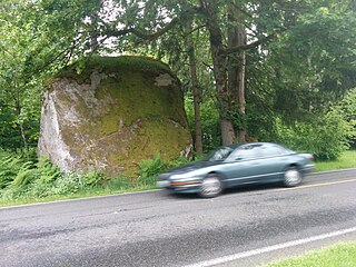
The Lawrence Lake erratic is a glacial erratic boulder near Lake Lawrence in Thurston County, Washington. The boulder is about 15 feet (4.6 m) tall. Lake Lawrence itself was formed when the Vashon Glaciation created most of the topography seen in the Puget Sound region. The erratic is one of the southernmost in the Puget Sound region, near the limit of the Yelm lobe of the Vashon Glacier in the Rainier area.

