List of lakes in Rosebud County, Montana

Last updated
Map all coordinates using: OpenStreetMap  ·  Google Maps
Download coordinates as: KML  ·  GPX

There are at least 69 named lakes and reservoirs in Rosebud County, Montana .

Lake A body of relatively still water, in a basin surrounded by land

A lake is an area filled with water, localized in a basin, that is surrounded by land, apart from any river or other outlet that serves to feed or drain the lake. Lakes lie on land and are not part of the ocean, and therefore are distinct from lagoons, and are also larger and deeper than ponds, though there are no official or scientific definitions. Lakes can be contrasted with rivers or streams, which are usually flowing. Most lakes are fed and drained by rivers and streams.

Reservoir A storage space for fluids

A reservoir is, most commonly, an enlarged natural or artificial lake, pond or impoundment created using a dam or lock to store water.
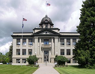
Rosebud County, Montana County in the state of Montana

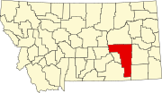
Rosebud County is a county in the state of Montana. It was established February 11, 1901, and has Montana vehicle license plate prefix 29. As of the 2010 United States Census, the population was 9,233. Its county seat is Forsyth.

Contents

Lakes

Reservoirs

Castle Rock Lake lake in Juneau County, Wisconsin, United States of America

Castle Rock Lake is a man-made lake located in central Wisconsin, in Adams County and Juneau County. It connects to Petenwell Lake. It covers 16,640 acres (67.3 km2) and reaches 30 feet (9.1 m) deep.

See also

Notes

  1. "Absolen Reservoir". Geographic Names Information System . United States Geological Survey.
  2. "Barley Reservoir". Geographic Names Information System . United States Geological Survey.
  3. "Barley Reservoirs". Geographic Names Information System . United States Geological Survey.
  4. "Big Reservoir". Geographic Names Information System . United States Geological Survey.
  5. "Bighead Reservoir". Geographic Names Information System . United States Geological Survey.
  6. "Black Canyon Reservoir". Geographic Names Information System . United States Geological Survey.
  7. "Black Coulee Reservoir". Geographic Names Information System . United States Geological Survey.
  8. "Black Sea Reservoir". Geographic Names Information System . United States Geological Survey.
  9. "Blacktail Reservoir". Geographic Names Information System . United States Geological Survey.
  10. "Boies Reservoir". Geographic Names Information System . United States Geological Survey.
  11. "Bowman Reservoir". Geographic Names Information System . United States Geological Survey.
  12. "Boyce Reservoir". Geographic Names Information System . United States Geological Survey.
  13. "Bridge Creek Reservoir". Geographic Names Information System . United States Geological Survey.
  14. "Brown Coulee Reservoir". Geographic Names Information System . United States Geological Survey.
  15. "Castle Rock Lake". Geographic Names Information System . United States Geological Survey.
  16. "Coal Bank Reservoir". Geographic Names Information System . United States Geological Survey.
  17. "Donald Reservoir". Geographic Names Information System . United States Geological Survey.
  18. "Donley Reservoir". Geographic Names Information System . United States Geological Survey.
  19. "Donleys Reservoir". Geographic Names Information System . United States Geological Survey.
  20. "East Fork Reservoir". Geographic Names Information System . United States Geological Survey.
  21. "East Fork Reservoir". Geographic Names Information System . United States Geological Survey.
  22. "Edith Reservoir". Geographic Names Information System . United States Geological Survey.
  23. "Experimental Pasture Reservoir". Geographic Names Information System . United States Geological Survey.
  24. "Fields Reservoir". Geographic Names Information System . United States Geological Survey.
  25. "Fisherman Dan Reservoir". Geographic Names Information System . United States Geological Survey.
  26. "Green Creek Reservoir". Geographic Names Information System . United States Geological Survey.
  27. "Hamilton Draw Reservoir". Geographic Names Information System . United States Geological Survey.
  28. "Haywood Reservoir". Geographic Names Information System . United States Geological Survey.
  29. "Hertzler Reservoir". Geographic Names Information System . United States Geological Survey.
  30. "Hoover Reservoir". Geographic Names Information System . United States Geological Survey.
  31. "Horse Creek Basin Reservoir". Geographic Names Information System . United States Geological Survey.
  32. "Kerns Reservoir". Geographic Names Information System . United States Geological Survey.
  33. "King Creek Reservoir". Geographic Names Information System . United States Geological Survey.
  34. "Kreger Reservoir". Geographic Names Information System . United States Geological Survey.
  35. "Lee Creek Reservoir". Geographic Names Information System . United States Geological Survey.
  36. "Lei Reservoir". Geographic Names Information System . United States Geological Survey.
  37. "Lower Blacktail Reservoir". Geographic Names Information System . United States Geological Survey.
  38. "Needle Butte Reservoir". Geographic Names Information System . United States Geological Survey.
  39. "Newell Creek Reservoir". Geographic Names Information System . United States Geological Survey.
  40. "O'Dell Reservoir". Geographic Names Information System . United States Geological Survey.
  41. "Pittman Reservoir". Geographic Names Information System . United States Geological Survey.
  42. "Poker Jim Reservoir". Geographic Names Information System . United States Geological Survey.
  43. "Poker Jim Reservoir Number Two". Geographic Names Information System . United States Geological Survey.
  44. "Poker Teechee Reservoir". Geographic Names Information System . United States Geological Survey.
  45. "Reavis Reservoir". Geographic Names Information System . United States Geological Survey.
  46. "Red Rock Reservoir Number One". Geographic Names Information System . United States Geological Survey.
  47. "Red Rock Reservoir Number Two". Geographic Names Information System . United States Geological Survey.
  48. "Redeen". Geographic Names Information System . United States Geological Survey.
  49. "Roberts Gulch Reservoir". Geographic Names Information System . United States Geological Survey.
  50. "Round Butte Reservoir". Geographic Names Information System . United States Geological Survey.
  51. "Round Cow Reservoir". Geographic Names Information System . United States Geological Survey.
  52. "Schaudel Reservoir". Geographic Names Information System . United States Geological Survey.
  53. "Skinny Reservoir". Geographic Names Information System . United States Geological Survey.
  54. "Snyder Reservoir". Geographic Names Information System . United States Geological Survey.
  55. "Stellar Lake". Geographic Names Information System . United States Geological Survey.
  56. "Sunday Creek Reservoir". Geographic Names Information System . United States Geological Survey.
  57. "Thebes Lake". Geographic Names Information System . United States Geological Survey.
  58. "Three X Bar Reservoir". Geographic Names Information System . United States Geological Survey.
  59. "Three X Bar Reservoir Number Two". Geographic Names Information System . United States Geological Survey.
  60. "Timber Creek Basin Reservoir". Geographic Names Information System . United States Geological Survey.
  61. "Timber Creek Reservoir". Geographic Names Information System . United States Geological Survey.
  62. "Trail Creek Reservoir". Geographic Names Information System . United States Geological Survey.
  63. "Wagner Reservoir". Geographic Names Information System . United States Geological Survey.
  64. "Water Gap Reservoir". Geographic Names Information System . United States Geological Survey.
  65. "Wolff Reservoir". Geographic Names Information System . United States Geological Survey.
  66. "Woodard Reservoir". Geographic Names Information System . United States Geological Survey.
  67. "Woodbury Reservoir". Geographic Names Information System . United States Geological Survey.
  68. "Zempel Lake". Geographic Names Information System . United States Geological Survey.
  69. "Zemple Lake". Geographic Names Information System . United States Geological Survey.

Related Research Articles

There are 45 streams named Willow Creek in the state of Montana.