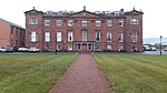
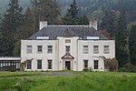
Name Location Date Listed Grid Ref. [note 1] Geo-coordinates Notes LB Number [note 2] Image Horsemill Farmhouse 56°21′41″N 3°25′14″W / 56.361404°N 3.42059°W / 56.361404; -3.42059 (Horsemill Farmhouse ) Category B 4504 Kinmonth House 56°21′37″N 3°21′34″W / 56.360256°N 3.359557°W / 56.360256; -3.359557 (Kinmonth House ) Category B 4507 Carmichael Cottages 56°20′43″N 3°26′35″W / 56.345312°N 3.443096°W / 56.345312; -3.443096 (Carmichael Cottages ) Category C(S) 4521 Kilgraston House Lodge 56°20′28″N 3°24′37″W / 56.341008°N 3.410302°W / 56.341008; -3.410302 (Kilgraston House Lodge ) Category B 4529 Moncreiffe Estate, The Stables 56°21′33″N 3°24′02″W / 56.359216°N 3.400454°W / 56.359216; -3.400454 (Moncreiffe Estate, The Stables ) Category B 4536 Drummonie House 56°20′16″N 3°25′47″W / 56.337893°N 3.429713°W / 56.337893; -3.429713 (Drummonie House ) Category A 163 Moncreiffe Estate, Former Dairy 56°21′35″N 3°23′53″W / 56.359594°N 3.398008°W / 56.359594; -3.398008 (Moncreiffe Estate, Former Dairy ) Category C(S) 51439 Moncreiffe Estate, Dovecote 56°21′35″N 3°24′12″W / 56.359777°N 3.403339°W / 56.359777; -3.403339 (Moncreiffe Estate, Dovecote ) Category B 4502 Kinmonth Doo'Cot 56°21′35″N 3°21′25″W / 56.359764°N 3.356869°W / 56.359764; -3.356869 (Kinmonth Doo'Cot ) Category B 4506 Kilgraston House 56°20′30″N 3°24′59″W / 56.341766°N 3.416333°W / 56.341766; -3.416333 (Kilgraston House ) Category A 4527 Upload another image See more images
Kilgraston Walled Garden 56°20′19″N 3°25′20″W / 56.338535°N 3.422328°W / 56.338535; -3.422328 (Kilgraston Walled Garden ) Category C(S) 4531 Balendrick House 56°20′32″N 3°25′40″W / 56.342163°N 3.427899°W / 56.342163; -3.427899 (Balendrick House ) Category B 4532 Bridge Of Earn, Back Street, Burnbrae, Burnside And Fetteresk 56°20′58″N 3°24′19″W / 56.349331°N 3.405334°W / 56.349331; -3.405334 (Bridge Of Earn, Back Street, Burnbrae, Burnside And Fetteresk ) Category C(S) 4542 Moncreiffe Estate, West Lodge Including Gate And Quadrant Walls 56°21′30″N 3°24′51″W / 56.358269°N 3.414242°W / 56.358269; -3.414242 (Moncreiffe Estate, West Lodge Including Gate And Quadrant Walls ) Category C(S) 51443 Bridge Of Earn Former Earnbank Hotel 56°20′58″N 3°24′11″W / 56.349374°N 3.403152°W / 56.349374; -3.403152 (Bridge Of Earn Former Earnbank Hotel ) Category C(S) 4515 Dunbarney Old Churchyard, Near Dunbarney House 56°21′18″N 3°26′11″W / 56.354871°N 3.436288°W / 56.354871; -3.436288 (Dunbarney Old Churchyard, Near Dunbarney House ) Category B 4516 Pitkeathly, Wellhouse Cottages 56°20′31″N 3°26′00″W / 56.341993°N 3.433361°W / 56.341993; -3.433361 (Pitkeathly, Wellhouse Cottages ) Category B 4523 Parish Church Of Dunbarney 56°21′02″N 3°24′33″W / 56.350572°N 3.409167°W / 56.350572; -3.409167 (Parish Church Of Dunbarney ) Category C(S) 4537 Cyprus Inn Bridge Of Earn 56°20′58″N 3°24′20″W / 56.349437°N 3.405468°W / 56.349437; -3.405468 (Cyprus Inn Bridge Of Earn ) Category C(S) 4541 Gilloch Hall Bridge Of Earn 56°20′57″N 3°24′18″W / 56.349092°N 3.405018°W / 56.349092; -3.405018 (Gilloch Hall Bridge Of Earn ) Category C(S) 4509 House And Surgery (Dr Paul Mackenzie) Viewfield, Inverine Main Street 56°20′55″N 3°24′22″W / 56.348577°N 3.406051°W / 56.348577; -3.406051 (House And Surgery (Dr Paul Mackenzie) Viewfield, Inverine Main Street ) Category C(S) 4513 Kilgraston House Former Stable Block 56°20′29″N 3°25′07″W / 56.341479°N 3.418619°W / 56.341479; -3.418619 (Kilgraston House Former Stable Block ) Category B 4530 Pitkeathly Wells Farmhouse 56°20′33″N 3°26′04″W / 56.342466°N 3.434365°W / 56.342466; -3.434365 (Pitkeathly Wells Farmhouse ) Category C(S) 4524 Kilgraston House Gates 56°20′28″N 3°24′37″W / 56.341127°N 3.410145°W / 56.341127; -3.410145 (Kilgraston House Gates ) Category B 4528 Moncreiffe Estate, East Gate 56°21′12″N 3°24′20″W / 56.3534°N 3.405484°W / 56.3534; -3.405484 (Moncreiffe Estate, East Gate ) Category C(S) 51437 Moncreiffe Estate, Garden Cottage, East And West 56°21′31″N 3°23′25″W / 56.358666°N 3.390302°W / 56.358666; -3.390302 (Moncreiffe Estate, Garden Cottage, East And West ) Category C(S) 51441 Moncreiffe Estate, Walled Garden And Ha-Ha 56°21′32″N 3°23′39″W / 56.358893°N 3.394097°W / 56.358893; -3.394097 (Moncreiffe Estate, Walled Garden And Ha-Ha ) Category C(S) 51442 Masonic Hall (Former Free Church Hall And Beadle's House) Bridge Of Earn 56°20′55″N 3°24′16″W / 56.348703°N 3.40447°W / 56.348703; -3.40447 (Masonic Hall (Former Free Church Hall And Beadle's House) Bridge Of Earn ) Category C(S) 4510 Haughfield House Kintillo 56°20′37″N 3°24′35″W / 56.343737°N 3.409756°W / 56.343737; -3.409756 (Haughfield House Kintillo ) Category C(S) 4514 Dunbarney House Windmill 56°20′58″N 3°26′45″W / 56.34934°N 3.445951°W / 56.34934; -3.445951 (Dunbarney House Windmill ) Category B 4520 Upload another image
Balendrick House Stables 56°20′31″N 3°25′37″W / 56.341913°N 3.427048°W / 56.341913; -3.427048 (Balendrick House Stables ) Category C(S) 4533 Moncreiffe Estate, Moncreiffe House Including Walls, Ancillary Buildings And Gatepiers 56°21′31″N 3°23′55″W / 56.358492°N 3.398501°W / 56.358492; -3.398501 (Moncreiffe Estate, Moncreiffe House Including Walls, Ancillary Buildings And Gatepiers ) Category B 4535 Upload another image
Dunbarney Churchyard 56°21′02″N 3°24′35″W / 56.350674°N 3.409721°W / 56.350674; -3.409721 (Dunbarney Churchyard ) Category C(S) 4539 Manse Of Dunbarney 56°21′05″N 3°24′33″W / 56.351506°N 3.409282°W / 56.351506; -3.409282 (Manse Of Dunbarney ) Category C(S) 4540 Moncreiffe Estate, Gamekeeper's Cottage And Kennels 56°21′33″N 3°24′39″W / 56.359152°N 3.410843°W / 56.359152; -3.410843 (Moncreiffe Estate, Gamekeeper's Cottage And Kennels ) Category C(S) 51440 Dunbarney House, Including Offices, And Garden Walls 56°21′09″N 3°26′25″W / 56.352595°N 3.440377°W / 56.352595; -3.440377 (Dunbarney House, Including Offices, And Garden Walls ) Category B 4517 Dunbarney House Sundial 56°21′08″N 3°26′24″W / 56.352256°N 3.440138°W / 56.352256; -3.440138 (Dunbarney House Sundial ) Category B 4518 Dunbarney House Doocot 56°21′05″N 3°26′30″W / 56.35152°N 3.441648°W / 56.35152; -3.441648 (Dunbarney House Doocot ) Category B 4519 Wallacetown Farmhouse 56°21′19″N 3°22′12″W / 56.355378°N 3.370065°W / 56.355378; -3.370065 (Wallacetown Farmhouse ) Category B 4505 Former Free Church (I Imrie, Antiques) Bridge Of Earn 56°20′55″N 3°24′16″W / 56.348632°N 3.404354°W / 56.348632; -3.404354 (Former Free Church (I Imrie, Antiques) Bridge Of Earn ) Category C(S) 4511 'sealsbridge House' Bridge Of Earn 56°20′54″N 3°24′13″W / 56.348244°N 3.403741°W / 56.348244; -3.403741 ('sealsbridge House' Bridge Of Earn ) Category C(S) 4512 Viewfield 56°20′45″N 3°25′56″W / 56.34594°N 3.432328°W / 56.34594; -3.432328 (Viewfield ) Category C(S) 4522 Pitkeathly Wells Steading 56°20′34″N 3°26′05″W / 56.34266°N 3.434696°W / 56.34266; -3.434696 (Pitkeathly Wells Steading ) Category C(S) 4525 Glenearn House Gatepiers 56°20′06″N 3°26′00″W / 56.33502°N 3.433358°W / 56.33502; -3.433358 (Glenearn House Gatepiers ) Category B 4526 Parish Church Of Dunbarney, Session Room 56°21′01″N 3°24′33″W / 56.350338°N 3.409207°W / 56.350338; -3.409207 (Parish Church Of Dunbarney, Session Room ) Category C(S) 4538 Moncreiffe Estate, Filter Bed And Water Tank 56°21′37″N 3°23′56″W / 56.360302°N 3.399005°W / 56.360302; -3.399005 (Moncreiffe Estate, Filter Bed And Water Tank ) Category C(S) 51438