Name Location Date Listed Grid Ref. [note 1] Geo-coordinates Notes LB Number [note 2] Image Old Linburn House Sundial In Walled Garden 55°53′57″N 3°24′25″W / 55.899074°N 3.407049°W / 55.899074; -3.407049 (Old Linburn House Sundial In Walled Garden ) Category B 7359 Ainville Farm-House 55°51′25″N 3°25′41″W / 55.856868°N 3.428097°W / 55.856868; -3.428097 (Ainville Farm-House ) Category B 7363 Kirknewton, Station Road, Parish Church (Church Of Scotland) And Halls Including Boundary Walls 55°53′17″N 3°25′52″W / 55.888095°N 3.431115°W / 55.888095; -3.431115 (Kirknewton, Station Road, Parish Church (Church Of Scotland) And Halls Including Boundary Walls ) Category C(S) 50535 Upload another image
Hill House 55°53′22″N 3°24′41″W / 55.889453°N 3.411497°W / 55.889453; -3.411497 (Hill House ) Category B 7352 South Gateway Hatton Estate 55°54′04″N 3°23′46″W / 55.901184°N 3.396201°W / 55.901184; -3.396201 (South Gateway Hatton Estate ) Category A 7355 Upload another image See more images
East Calder Village St. Cuthbert's Church 55°53′41″N 3°27′58″W / 55.894657°N 3.466027°W / 55.894657; -3.466027 (East Calder Village St. Cuthbert's Church ) Category B 7366 Upload another image See more images
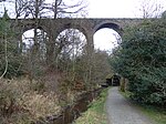
2, 4 Smithybrae 55°53′15″N 3°25′07″W / 55.887439°N 3.418635°W / 55.887439; -3.418635 (2, 4 Smithybrae ) Category C(S) 7383 Ormiston Hill House 55°52′56″N 3°26′22″W / 55.882175°N 3.439418°W / 55.882175; -3.439418 (Ormiston Hill House ) Category C(S) 13646 South Gate-Way Almondell Park 55°53′51″N 3°27′19″W / 55.897615°N 3.455247°W / 55.897615; -3.455247 (South Gate-Way Almondell Park ) Category B 7369 Maconochies Of Meadowbank Burial Enclosure Kirknewton Burial Ground 55°53′15″N 3°25′04″W / 55.887385°N 3.417866°W / 55.887385; -3.417866 (Maconochies Of Meadowbank Burial Enclosure Kirknewton Burial Ground ) Category B 7384 Merivil Cottage 55°53′40″N 3°28′01″W / 55.894351°N 3.466847°W / 55.894351; -3.466847 (Merivil Cottage ) Category B 13647 Ormiston House 55°53′02″N 3°26′29″W / 55.883976°N 3.441387°W / 55.883976; -3.441387 (Ormiston House ) Category B 7358 Leithhead Farm, By The Water Of Leith 55°51′27″N 3°25′01″W / 55.857598°N 3.416988°W / 55.857598; -3.416988 (Leithhead Farm, By The Water Of Leith ) Category C(S) 7364 Kirknewton, Easter Colzium 55°48′44″N 3°27′55″W / 55.812103°N 3.465267°W / 55.812103; -3.465267 (Kirknewton, Easter Colzium ) Category C(S) 43570 Kirknewton Station, Station House 55°53′21″N 3°26′01″W / 55.889054°N 3.433644°W / 55.889054; -3.433644 (Kirknewton Station, Station House ) Category B 13466 Lodges, 19 And 21 Whitemoss Road, And Gate, Kirknewton Village 55°53′10″N 3°25′09″W / 55.886201°N 3.419277°W / 55.886201; -3.419277 (Lodges, 19 And 21 Whitemoss Road, And Gate, Kirknewton Village ) Category B 7348 Waterloo Tower 55°53′40″N 3°23′58″W / 55.89455°N 3.399545°W / 55.89455; -3.399545 (Waterloo Tower ) Category B 7354 Bridge Gogar Burn, Ormiston Estate 55°53′04″N 3°26′25″W / 55.884367°N 3.440186°W / 55.884367; -3.440186 (Bridge Gogar Burn, Ormiston Estate ) Category C(S) 7361 Railway Viaduct , Linhouse Water 55°52′03″N 3°28′37″W / 55.867414°N 3.477049°W / 55.867414; -3.477049 (Railway Viaduct, Linhouse Water ) Category A 7365 Upload another image See more images
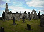
Dr. Cullen Burial Enclosure 55°53′15″N 3°25′03″W / 55.887434°N 3.417564°W / 55.887434; -3.417564 (Dr. Cullen Burial Enclosure ) Category B 7351 Upload another image See more images
Easter Newton Farm-House 55°53′17″N 3°24′14″W / 55.888056°N 3.404012°W / 55.888056; -3.404012 (Easter Newton Farm-House ) Category B 7353 Millrigg Farmhouse 55°53′26″N 3°26′25″W / 55.890675°N 3.440196°W / 55.890675; -3.440196 (Millrigg Farmhouse ) Category B 7357 14, 16, 18, 20, 22 And 24 Main Street 55°53′16″N 3°25′08″W / 55.887662°N 3.418787°W / 55.887662; -3.418787 (14, 16, 18, 20, 22 And 24 Main Street ) Category C(S) 7382 Kirknewton, Station Road, The Old School House 55°53′17″N 3°25′51″W / 55.888017°N 3.43084°W / 55.888017; -3.43084 (Kirknewton, Station Road, The Old School House ) Category C(S) 50536 Ormiston Mains Steading 55°53′18″N 3°26′26″W / 55.888325°N 3.440669°W / 55.888325; -3.440669 (Ormiston Mains Steading ) Category C(S) 7360 Raw Farm-House 55°53′49″N 3°26′59″W / 55.896961°N 3.449785°W / 55.896961; -3.449785 (Raw Farm-House ) Category C(S) 7367 Overshiel Farm-House 55°54′15″N 3°26′28″W / 55.904178°N 3.44124°W / 55.904178; -3.44124 (Overshiel Farm-House ) Category B 7368 Canal Feeder Aqueduct , River Almond 55°54′04″N 3°27′46″W / 55.901166°N 3.462721°W / 55.901166; -3.462721 (Canal Feeder Aqueduct, River Almond ) Category A 7371 Upload another image See more images
Mineral Railway Viaduct , River Almond 55°54′00″N 3°27′47″W / 55.900102°N 3.463033°W / 55.900102; -3.463033 (Mineral Railway Viaduct, River Almond ) Category B 7372 Upload another image See more images
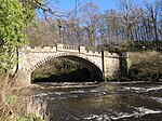
'sawmill House', 5 Whitemoss Road 55°53′14″N 3°25′11″W / 55.887211°N 3.419746°W / 55.887211; -3.419746 ('sawmill House', 5 Whitemoss Road ) Category C(S) 7381 East Gate-Lodge And Gate-Way Linburn Park 55°54′03″N 3°23′59″W / 55.900865°N 3.39974°W / 55.900865; -3.39974 (East Gate-Lodge And Gate-Way Linburn Park ) Category B 7356 Kirknewton House 55°53′00″N 3°24′57″W / 55.883249°N 3.415796°W / 55.883249; -3.415796 (Kirknewton House ) Category B 7362 Almondell Bridge , River Almond 55°54′14″N 3°27′36″W / 55.903984°N 3.460012°W / 55.903984; -3.460012 (Almondell Bridge, River Almond ) Category A 7370 Upload another image
Raw Camps Lime Kilns 55°54′00″N 3°26′49″W / 55.899886°N 3.447079°W / 55.899886; -3.447079 (Raw Camps Lime Kilns ) Category B 7373