
Midlothian is a historic county, registration county, lieutenancy area and one of 32 council areas of Scotland used for local government. Midlothian lies in the east-central Lowlands, bordering the City of Edinburgh, East Lothian and the Scottish Borders.
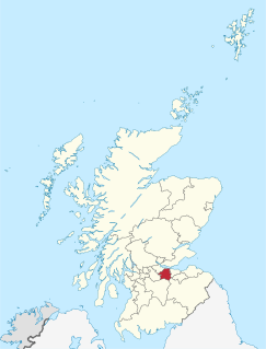
West Lothian is one of the 32 council areas of Scotland, and was one of its historic counties. The county, which was known as Linlithgowshire, was bounded geographically by the Avon to the west and the Almond to the east. The modern council area occupies a larger area than the historic county. It was reshaped following local government reforms in the late 20th century: some areas in the west were transferred to Falkirk; some areas in the east were transferred to Edinburgh; and some areas that had formerly been part of in Midlothian were added.

Livingston is a county constituency of the House of Commons of the Parliament of the United Kingdom, to which it returns one Member of Parliament (MP). Elections are held using the first-past-the-post voting system.
Sighthill is a suburb in the west of Edinburgh, Scotland. The area is bordered by Broomhouse and Parkhead to the east, South Gyle to the north, the industrial suburb of Bankhead and the Calders neighbourhood to the west, and Wester Hailes to the south. It is sometimes included in the Wester Hailes area, while the Calders, Bankhead and Parkhead are sometimes considered parts of Sighthill. Administratively it has formed a core part of the City of Edinburgh Council's Sighthill/Gorgie ward since 2007.

The Calders is a residential neighbourhood in Edinburgh, Scotland – not to be confused with the Calders of West Lothian aka West Calder, Mid Calder and East Calder, three separate villages. It is sometimes considered to be part of Wester Hailes or Sighthill, larger developments to its south and east respectively. From 2007 to 2017, it fell within the Sighthill/Gorgie multi-member ward of the City of Edinburgh Council administration along with Sighthill, but following a boundary change has been in the Pentland Hills ward since then, along with Wester Hailes.

Mid Calder is a village in West Lothian, Scotland. It is located on a steep hill overlooking the River Almond and Calder Wood, around 15 miles (24 km) west of Edinburgh. The settlement has been on a major crossroads since its origin some time in the 11th century.

West Calder is a village in the council area of West Lothian, Scotland, located four miles west of Livingston. Historically it is within the County of Midlothian. The village was an important centre in the oil shale industry in the 19th and 20th Centuries. West Calder has its own railway station. The surrounding villages that take West Calder's name in their address - Polbeth, Addiewell, Loganlea, Harburn and Westwood - outline the area that this village encompasses, and they all have played an important part in the history of the village as well as West Lothian. The village is a 10-minute drive from Livingston, which is host to two large shopping centres. The village lies along the ridge above the Calder burn.

East Calder is a village located in West Lothian, Scotland, about a mile east of Mid Calder and a mile west of Wilkieston. It forms part of 'the Calders, three small neighbouring communities situated west of Edinburgh and south of the "New Town" of Livingston.
West Calder United Football Club are a Scottish football club based in West Calder, West Lothian. Their home ground is Hermand Park, West Calder. Club colours are red and black.

Kingscavil (NT029765) is a small settlement in West Lothian lying between Linlithgow and Bridgend on the old A9.
Harperrig Reservoir is a reservoir in West Lothian, Scotland, to the north of the Pentland Hills, four miles (6.4 km) south of Mid Calder. The Water of Leith flows through it, and nearby are Harlaw Reservoir and Threipmuir Reservoir. It has been proposed that the reservoir be designated as a local nature reserve to be managed by West Lothian Council.
West Calder High School is a secondary school in West Calder, West Lothian, Scotland. The current school building was opened in 2018.

James Graham Fairley FRIBA MSGS (1846–1934) was a 19th/20th century Scottish architect working mainly in the West Lothian area, specialising in churches and schools.

East Livingston and East Calder is one of the nine wards used to elect members of the West Lothian Council. It elects four Councillors.

The Almondell Viaduct, also known as the Camps Viaduct, is a viaduct spanning the gorge of the River Almond in Scotland, located in East Calder, West Lothian, as well as the main canal feeder taking water from the Almond to the Union Canal at Lin's Mill near Ratho
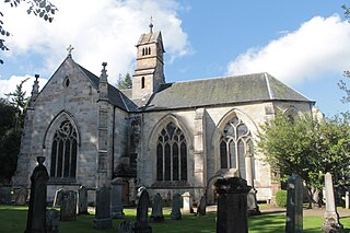
Kirk of Calder is a medieval church in Mid Calder, West Lothian. It is listed as a Category A building by Historic Environment Scotland. The church is of Ashlar stone in a Gothic style. The present Kirk dates from 1541 but was built on the site of an earlier 12th century church.
The 2022 West Lothian Council elections will be held on 5 May 2022. Elected positions in all 9 wards created as a result of the Local Governance (Scotland) Act 2004 are up for election, with each ward electing three or four Councillors using the single transferable vote system form of proportional representation, with 33 Councillors being elected in total.