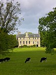
Name Location Date Listed Grid Ref. [note 1] Geo-coordinates Notes LB Number [note 2] Image 68 Main Street 55°53′27″N 3°28′56″W / 55.89076°N 3.482238°W / 55.89076; -3.482238 (68 Main Street ) Category C(S) 14146 Calder House 55°53′22″N 3°29′04″W / 55.889432°N 3.484362°W / 55.889432; -3.484362 (Calder House ) Category A 14153 Upload another image See more images
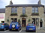
Wester Causewayend Farmhouse And Steading 55°49′58″N 3°27′55″W / 55.832716°N 3.465339°W / 55.832716; -3.465339 (Wester Causewayend Farmhouse And Steading ) Category B 18980 Westfield House 55°51′31″N 3°31′40″W / 55.858574°N 3.527649°W / 55.858574; -3.527649 (Westfield House ) Category B 18442 Alderston House, With Offices 55°52′49″N 3°31′48″W / 55.880212°N 3.52989°W / 55.880212; -3.52989 (Alderston House, With Offices ) Category B 18443 Murieston House, Easter Murieston 55°51′57″N 3°30′24″W / 55.865931°N 3.506716°W / 55.865931; -3.506716 (Murieston House, Easter Murieston ) Category B 14134 Black Bull Inn 6-4A-4 Market Street 55°53′33″N 3°28′52″W / 55.892518°N 3.481057°W / 55.892518; -3.481057 (Black Bull Inn 6-4A-4 Market Street ) Category C(S) 14136 Upload another image See more images
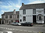
23-25 Bank Street 55°53′34″N 3°28′49″W / 55.892807°N 3.480189°W / 55.892807; -3.480189 (23-25 Bank Street ) Category C(S) 14141 41, 43, 47 Bank Street 55°53′34″N 3°28′46″W / 55.892904°N 3.479569°W / 55.892904; -3.479569 (41, 43, 47 Bank Street ) Category B 14149 Torphichen Arms Hotel, Bank Street 55°53′33″N 3°28′47″W / 55.892613°N 3.479846°W / 55.892613; -3.479846 (Torphichen Arms Hotel, Bank Street ) Category B 14150 Upload another image
Howden Bridge 55°53′19″N 3°30′13″W / 55.888713°N 3.503586°W / 55.888713; -3.503586 (Howden Bridge ) Category B 14163 Upload another image See more images
Williamston Bridge 55°52′31″N 3°29′42″W / 55.875347°N 3.495077°W / 55.875347; -3.495077 (Williamston Bridge ) Category C(S) 14164 Bridge, Murieston House 55°51′57″N 3°30′21″W / 55.865845°N 3.505706°W / 55.865845; -3.505706 (Bridge, Murieston House ) Category B 18833 Alderston Park, Doocot 55°52′50″N 3°31′46″W / 55.880594°N 3.529505°W / 55.880594; -3.529505 (Alderston Park, Doocot ) Category B 18444 Newpark House 55°52′00″N 3°31′19″W / 55.866617°N 3.52186°W / 55.866617; -3.52186 (Newpark House ) Category C(S) 14143 Midcalder Village Mid Calder Parish Kirk (St. John's Church) Main Street 55°53′24″N 3°28′57″W / 55.8901°N 3.48258°W / 55.8901; -3.48258 (Midcalder Village Mid Calder Parish Kirk (St. John's Church) Main Street ) Category A 14144 Calder Steading 55°53′16″N 3°29′19″W / 55.887915°N 3.488653°W / 55.887915; -3.488653 (Calder Steading ) Category B 14154 Gateway, Calder Estate, West Calder Road 55°53′20″N 3°28′54″W / 55.888889°N 3.481719°W / 55.888889; -3.481719 (Gateway, Calder Estate, West Calder Road ) Category A 14155 Upload another image
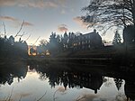
Oak Cafe 11 Bank Street 55°53′33″N 3°28′51″W / 55.892486°N 3.480752°W / 55.892486; -3.480752 (Oak Cafe 11 Bank Street ) Category C(S) 14138 Brewery House, 70 Main Street 55°53′26″N 3°28′56″W / 55.89052°N 3.482101°W / 55.89052; -3.482101 (Brewery House, 70 Main Street ) Category B 14145 Livingston Bridge, River Almond 55°53′05″N 3°32′21″W / 55.884645°N 3.539049°W / 55.884645; -3.539049 (Livingston Bridge, River Almond ) Category B 14161 Cairns Castle, Easter Cairns, By Harperrig Reservoir 55°49′45″N 3°27′13″W / 55.829215°N 3.453697°W / 55.829215; -3.453697 (Cairns Castle, Easter Cairns, By Harperrig Reservoir ) Category B 47559 Skivo Farm (Skivo Kennels) 55°51′26″N 3°30′51″W / 55.857338°N 3.514244°W / 55.857338; -3.514244 (Skivo Farm (Skivo Kennels) ) Category C(S) 14135 37-39 Bank Street 55°53′35″N 3°28′47″W / 55.893018°N 3.479829°W / 55.893018; -3.479829 (37-39 Bank Street ) Category C(S) 14142 35 Bank Street 55°53′35″N 3°28′48″W / 55.892917°N 3.479985°W / 55.892917; -3.479985 (35 Bank Street ) Category C(S) 14148 East Bridge, Linhouse Water, East Calder Road 55°53′34″N 3°28′41″W / 55.892735°N 3.477931°W / 55.892735; -3.477931 (East Bridge, Linhouse Water, East Calder Road ) Category B 14151 Howden House 55°53′34″N 3°31′02″W / 55.892734°N 3.517222°W / 55.892734; -3.517222 (Howden House ) Category B 14162 Bellsquarry, 30 Calder Road With Boundary Walls 55°52′10″N 3°31′37″W / 55.869457°N 3.526926°W / 55.869457; -3.526926 (Bellsquarry, 30 Calder Road With Boundary Walls ) Category C(S) 44584 19-21-21A Bank Street 55°53′34″N 3°28′49″W / 55.892725°N 3.480314°W / 55.892725; -3.480314 (19-21-21A Bank Street ) Category C(S) 19670 2 Market Street 55°53′33″N 3°28′51″W / 55.892403°N 3.480877°W / 55.892403; -3.480877 (2 Market Street ) Category C(S) 14137 The Old Schoolhouse Causewayend Kirknewton 55°50′03″N 3°27′30″W / 55.834102°N 3.458302°W / 55.834102; -3.458302 (The Old Schoolhouse Causewayend Kirknewton ) Category B 14158 House, Pumpherston Road 55°53′36″N 3°28′40″W / 55.893403°N 3.477733°W / 55.893403; -3.477733 (House, Pumpherston Road ) Category B 19671 15 (Formerly 13-15) Bank Street 55°53′33″N 3°28′50″W / 55.89255°N 3.480675°W / 55.89255; -3.480675 (15 (Formerly 13-15) Bank Street ) Category C(S) 14139 Clydesdale Bank 17 Bank Street 55°53′33″N 3°28′50″W / 55.892632°N 3.480534°W / 55.892632; -3.480534 (Clydesdale Bank 17 Bank Street ) Category C(S) 14140 29 Bank Street 55°53′34″N 3°28′48″W / 55.892871°N 3.480127°W / 55.892871; -3.480127 (29 Bank Street ) Category B 14147 Linhouse Mansion 55°51′03″N 3°29′57″W / 55.85071°N 3.499258°W / 55.85071; -3.499258 (Linhouse Mansion ) Category A 14156 Upload another image
Doocot, Linhouse 55°51′07″N 3°30′05″W / 55.851953°N 3.501287°W / 55.851953; -3.501287 (Doocot, Linhouse ) Category B 14157 Stables, The Old Schoolhouse, Causewayend Kirknewton 55°50′04″N 3°27′31″W / 55.834441°N 3.458522°W / 55.834441; -3.458522 (Stables, The Old Schoolhouse, Causewayend Kirknewton ) Category B 14159 Brucefield Farmhouse And Steading 55°51′59″N 3°32′07″W / 55.866422°N 3.535372°W / 55.866422; -3.535372 (Brucefield Farmhouse And Steading ) Category B 14160 Bankton House 55°52′28″N 3°30′04″W / 55.874581°N 3.501169°W / 55.874581; -3.501169 (Bankton House ) Category B 19672 Wester Murieston, Murieston Castle 55°51′19″N 3°31′08″W / 55.855195°N 3.519017°W / 55.855195; -3.519017 (Wester Murieston, Murieston Castle ) Category B 18441 Gate-Lodge And Gate-Way, Calder Estate, Bank Street 55°53′32″N 3°28′50″W / 55.892282°N 3.480505°W / 55.892282; -3.480505 (Gate-Lodge And Gate-Way, Calder Estate, Bank Street ) Category C(S) 14152