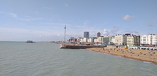
Brighton is a seaside resort and one of the two main areas of the City of Brighton and Hove. Located on the south coast of England, in the county of East Sussex, it is 47 miles (76 km) south of London.
Brighton and Hove is a city and unitary authority in East Sussex, England. It consists primarily of the settlements of Brighton and Hove, alongside neighbouring villages.

Brighton Kemptown, often referred to as Brighton Kemptown and Peacehaven by local political parties, is a constituency represented in the House of Commons of the UK Parliament since 2017 by Lloyd Russell-Moyle, a Labour Co-op MP.

Stanmer Park is a large public park immediately to the west of the University of Sussex, and to the north-east of the city of Brighton in the county of East Sussex, England, UK. It is a Local Nature Reserve and English Heritage, under the National Heritage Act 1983, has registered the park on the Register of Parks and Gardens of Special Historic Interest in England at Grade II level.

Moulsecoomb is a suburb of Brighton, England, on the northeast side around Lewes Road, between Coldean and Bevendean, 2+1⁄4 miles (3.6 km) north of the seafront. The eastern edge adjoins Falmer Hill on the South Downs. It is often divided into smaller sections on maps: North Moulsecoomb, East Moulsecoomb and South Moulsecoomb.
Coldean is a suburb of the English city of Brighton and Hove. Located in the northeast corner of the urban area, it was developed by Brighton Corporation in the 1950s as one of several postwar council estates necessitated by the acute housing shortage in the area after World War II.

Hangleton is a residential suburb of Hove, part of the English city and coastal resort of Brighton and Hove. The area was developed in the 1930s after it was incorporated into the borough of Hove, but has ancient origins: its parish church was founded in the 11th century and retains 12th-century fabric, and the medieval manor house is Hove's oldest secular building. The village became depopulated in the medieval era and the church fell into ruins, and the population in the isolated hilltop parish only reached 100 in the early 20th century; but rapid 20th-century development resulted in more than 6,000 people living in Hangleton in 1951 and over 9,000 in 1961. By 2013 the population exceeded 14,000.
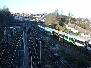
Public transport in Brighton and Hove, a city on the south coast of England, dates back to 1840. Brighton and Hove has a major railway station, an extensive bus service, many taxis, coach services, and it has previously had trolley buses, ferries, trams, auto rickshaws and hydrofoils.

Mile Oak is a locality forming the northern part of the former parish of Portslade in the northwest corner of the city of Brighton and Hove, England. Now mostly residential, but originally an area of good-quality agricultural land, it covers the area north of Portslade village as far as the urban boundary.

Hollingdean is a district in the city of Brighton & Hove. The Ward is called Hollingdean and Stanmer with a population of 15,681 at the 2011 Census. Hollingdean is in effect the older part of Hollingbury. It is bounded by Ditchling Road to the west, the Round Hill area to the south, and Lewes Road and Moulsecoomb to the east. It is a mainly residential area, with many council houses to the east and low-rise flats in the central part, with late 19th and early 20th-century terraced houses towards Fiveways, and some railway land, light industry, and warehousing.

Brighton and Hove City Council is the local authority of the city of Brighton and Hove. It is a unitary authority, having the powers of a non-metropolitan county and district council combined. It provides a full range of local government services including Council Tax billing, libraries, social services, processing planning applications, waste collection and disposal, and it is a local education authority.

Brighton and Hove, a city on the English Channel coast in southeast England, has a large and diverse stock of buildings "unrivalled architecturally" among the country's seaside resorts. The urban area, designated a city in 2000, is made up of the formerly separate towns of Brighton and Hove, nearby villages such as Portslade, Patcham and Rottingdean, and 20th-century estates such as Moulsecoomb and Mile Oak. The conurbation was first united in 1997 as a unitary authority and has a population of about 253,000. About half of the 20,430-acre (8,270 ha) geographical area is classed as built up.

The English coastal city of Brighton and Hove, made up of the formerly separate Boroughs of Brighton and Hove in East Sussex, has a wide range of cemeteries throughout its urban area. Many were established in the mid-19th century, a time in which the Victorian "cult of death" encouraged extravagant, expensive memorials set in carefully cultivated landscapes which were even recommended as tourist attractions. Some of the largest, such as the Extra Mural Cemetery and the Brighton and Preston Cemetery, were set in particularly impressive natural landscapes. Brighton and Hove City Council, the local authority responsible for public services in the city, manages seven cemeteries, one of which also has the city's main crematorium. An eighth cemetery and a second crematorium are owned by a private company. Many cemeteries are full and no longer accept new burials. The council maintains administrative offices and a mortuary at the Woodvale Cemetery, and employs a coroner and support staff.

The Bear Road area is a largely residential area in the east of Brighton, part of the English city of Brighton and Hove. Centred on the steep west–east road of that name, it is characterised by terraced houses of the early 20th century, but Brighton's main cemeteries were established here in the 19th century and there is also some industry.