Planned/Future Mergers
| | This section is empty. You can help by adding to it. (March 2013) |
Here is a list of mergers in Tochigi Prefecture, Japan since the Heisei era.
| | This section is empty. You can help by adding to it. (March 2013) |

Tochigi Prefecture is a prefecture of Japan located in the Kantō region of Honshu. Tochigi Prefecture has a population of 1,943,886 and has a geographic area of 6,408 km2. Tochigi Prefecture borders Fukushima Prefecture to the north, Gunma Prefecture to the west, Saitama Prefecture to the south, and Ibaraki Prefecture to the southeast.

Tochigi is a city located in Tochigi Prefecture, in the northern Kantō region of Japan. As of 1 August 2020, the city had an estimated population of 159,056 in 66,018 households, and a population density of 480 persons per km². The total area of the city is 331.50 square kilometres (127.99 sq mi). Because the city escaped war damage during World War II, many historical temples, traditional shops and kura remain in the city center. The city was awarded the "Utsukushii-machinami Taisho" prize from the Ministry of Land, Infrastructure, Transport and Tourism in 2009.
Utsunomiya is the prefectural capital city of Tochigi Prefecture in the northern Kantō region of Japan. As of 1 January 2020, the city had an estimated population of 519,223, and a population density of 1,246 persons per square kilometre (3,230/sq mi). The total area of the city is 416.85 km2 (160.95 sq mi). Utsunomiya is famous for its gyoza. There are more than two hundred gyoza restaurants in Utsunomiya.

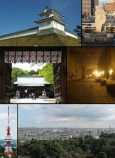
Sano is a city located in Tochigi Prefecture, Japan. As of 1 August 2020, the city had an estimated population of 117,669, in 52,066 households and a population density of 330 persons per km2. The total area of the city is 356.04 square kilometres (137.47 sq mi). The city is known for its Outlet Mall, Sano Yakuyoke Daishi Temple, and its local variety of ramen, Sano Ramen. More recently, Sano has gained international recognition for being the home of cricket in Japan.

Nikkō is a city located in Tochigi Prefecture, Japan. As of 2 December 2020, the city had an estimated population of 80,239 in 36,531 households, and a population density of 55 persons per km2. The total area of the city is 1,449.83 square kilometres (559.78 sq mi). It is a popular destination for Japanese and international tourists. Attractions include the mausoleum of shōgun Tokugawa Ieyasu and that of his grandson Iemitsu, and the Futarasan Shrine, which dates to the year 767 AD. There are also many famous hot springs (onsen) in the area. Elevations range from 200 to 2,000 meters. The Japanese saying 【日光を見ずして結構と言うなかれ】 "Never say 'kekkō' until you've seen Nikkō"—kekkō meaning beautiful, magnificent or "I am satisfied"—is a reflection of the beauty and sites in Nikkō.

Imaichi was a city located in Tochigi Prefecture, Japan.

Shimotsuke Province was a province of Japan in the area of Japan that is today Tochigi Prefecture. Shimotsuke was bordered by Kōzuke, Hitachi, Mutsu and Shimōsa Provinces. Its abbreviated form name was Yashū (野州). Under the Engishiki classification system, Shimotsuke was ranked as one of the 13 "great countries" (大国) in terms of importance, and one of the 30 "far countries" (遠国) in terms of distance from the capital. The provincial capital is located in what is now the city of Tochigi. The Ichinomiya of the province is the Futarasan jinja located in what is now the city of Utsunomiya.
Kamitsuga was a district located in Tochigi Prefecture, Japan.

Kuriyama was a village located in Shioya District, Tochigi Prefecture, Japan.

Shioya is a town located in Tochigi Prefecture, Japan. As of 1 August 2020, the town had an estimated population of 10,906 in 4028 households, and a population density of 62 persons per km². The total area of the town is 176.06 square kilometres (67.98 sq mi).

Takanezawa is a town located in Tochigi Prefecture, Japan. As of 1 July 2020, the town had an estimated population of 29,528 in 12,618 households, and a population density of 420 persons per km². The total area of the town is 70.87 square kilometres (70,870,000 m2)
Shioya is a district in Tochigi Prefecture, Japan.
Aso was a district located in Tochigi Prefecture, Japan.
Kawachi is a district located in Tochigi Prefecture, Japan.
Nasushiobara is a city located in Tochigi Prefecture, Japan. As of 1 August 2020, the city had an estimated population of 115,794 in 48,437 households, and a population density of 67 persons per km². The total area of the city is 592.74 square kilometres (228.86 sq mi).
| Core city |  | |
|---|---|---|
| Cities | ||
| Districts | ||