The following is a list of mosques found within the territory of modern Armenia.
According to the 1870 publication of the Caucasian Calendar, a statistical report published by the Russian Viceroyalty of the Caucasus, there were a total of 269 Shia mosques in Erivan Governorate, a territory which today which comprises most of central Armenia, the Iğdır Province of Turkey, and the Nakhichevan exclave of Azerbaijan. [1]
According to Brockhaus and Efron Encyclopedic Dictionary , by the turn of the twentieth century, the population of Erivan (modern Yerevan), center of the Erivan Governorate, was over 29,000; of this number 49% were "Aderbeydzhani Tatars" (modern Azerbaijanis), 48% were Armenians and 2% were Russians, and there were seven Shia mosques in Erivan. [2] According to the traveler H. F. B. Lynch, the city of Erivan was about 50% Armenian and 50% Muslim in the early 1890s. [3] H. F. B. Lynch thought that some among the Muslims were Persians when he visited the city within the same decade. [4] According to modern historians George Bournoutian and Robert H. Hewsen, however, Lynch thought many were Persian. [5]
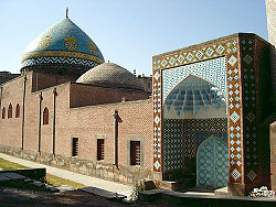
After the capture of Yerevan by Russians as a result of the Russo-Persian War, the main mosque in the city fortress, built by Turks in 1582, was converted to an Orthodox church under the orders of the Russian commander, General Ivan Paskevich. The church was sanctified on December 6, 1827, and named the Church of the Intercession of the Holy Mother of God. [6]
According to Ivan Chopin, there were eight mosques in Yerevan in the middle of the nineteenth century:
After 1917, many of the city's religious buildings were demolished in accordance with the Soviet government's modernization and anti-religious policies. The campaign saw the demolishment of churches, mosques, and the only synagogue in the city. [9] According to the journalists Robert Cullen and Thomas de Waal, a few residents of Vardanants Street recall a small mosque being demolished in 1990. [10] [11] In 1988–1994 the overwhelming majority of the Muslim population, consisting of Azeris and Muslim Kurds,[ citation needed ] fled the country as a result of the First Nagorno-Karabakh War and the ongoing conflict between Armenia and Azerbaijan.
The Nakhichevan Khanate was a khanate under Iranian suzerainty, which controlled the city of Nakhichevan and its surroundings from 1747 to 1828.
The Erivan Khanate, also known as Chokhur-e Sa'd, was a khanate that was established in Afsharid Iran in the 18th century. It covered an area of roughly 19,500 km2, and corresponded to most of present-day central Armenia, the Iğdır Province and the Kars Province's Kağızman district in present-day Turkey and the Sharur and Sadarak districts of the Nakhchivan Autonomous Republic of present-day Azerbaijan.
The Blue Mosque is an 18th-century Shia mosque in Yerevan, Armenia. It was commissioned by Hoseyn Ali Khan, the khan of the Iranian Erivan Khanate. It is one of the oldest extant structures in central Yerevan and the most significant structure from the city's Iranian period. It was the largest of the eight mosques of Yerevan in the 19th century and is the only active mosque in Armenia today.
The Erivan Governorate was a province (guberniya) of the Caucasus Viceroyalty of the Russian Empire, with its centеr in Erivan. Its area was 27,830 sq. kilometеrs, roughly corresponding to what is now most of central Armenia, the Iğdır Province of Turkey, and the Nakhchivan exclave of Azerbaijan. At the end of the 19th century, it bordered the Tiflis Governorate to the north, the Elizavetpol Governorate to the east, the Kars Oblast to the west, and Persia and the Ottoman Empire to the south. Mount Ararat and the fertile Ararat Valley were included in the center of the province.
Azerbaijanis in Armenia numbered 29 people according to the 2001 census of Armenia. Although they have previously been the biggest minority in the country according to 1831–1989 censuses, they are virtually non-existent since 1988–1991 when most fled or were forced out of the country as a result of the tensions of the First Nagorno-Karabakh War to neighboring Azerbaijan. The UNHCR estimates that the current population of Azerbaijanis in Armenia to be somewhere between 30 and a few hundred people, with most of them living in rural areas as members of mixed couples, as well as elderly or sick. Most of them are reported to have changed their names to maintain a low profile to avoid discrimination.
Berdkunk is a village in the Gavar Municipality of the Gegharkunik Province of Armenia.
Drakhtik is a village in the Shoghakat Municipality of the Gegharkunik Province of Armenia.
Shurnukh is a village in the Goris Municipality of the Syunik Province in Armenia.
Askeran is a town in the Khojaly District of Azerbaijan, in the disputed region of Nagorno-Karabakh. Prior to the 2023 Azerbaijani offensive, it was de facto in the Republic of Artsakh as the administrative centre of its Askeran Province. It is located on the left bank of the Karkar River (Qarqarçay), approximately 11 kilometres (7 mi) northeast of the regional capital, Stepanakert.
The history of modern Yerevan, the capital of Armenia, traces its roots back to Erebuni Fortress an ancient Urartian fortified monument from which also the modern city of Yerevan derives its name. The earliest reference to Yerevan in the medieval records dates from 607 A.D. Located one in the bottommost parts of the Armenian Highlands, the city lies on the banks of the rivers Getar and Hrazdan, the easternmost end of the Ararat Plain. Several ancient and medieval Armenian capitals are situated in the vicinity of Yerevan. From the early 15th century onwards, the city was the administrative center of the Safavid Empire; in the mid-18th century it was proclaimed the capital of the Erivan Khanate, in 1918 - the capital of the First Republic of Armenia and in - 1920 - the capital of Armenian Soviet Socialist Republic. Since 1991, Yerevan has been the capital of the Third Republic of Armenia.
Yerevan Fortress was a 16th-century fortress in Yerevan.
Askeran Fortress is a fortress in the town of Askeran, Azerbaijan. Located on the banks of the Qarqar River, its current structure was built in the 18th-century and consists of two sections. The left-bank section features a double line of stone walls.
Vank or Vangli is a village in the Kalbajar District of Azerbaijan, in the disputed region of Nagorno-Karabakh. The village had an Armenian majority in 1989. The 13th-century Gandzasar Monastery, and the 9th-century Khokhanaberd fortress are located near Vank.
Mark Grigorian was a Soviet Armenian Neoclassical architect.
Lilit Kamo Makunts is an Armenian philologist and politician who currently serves as the Armenian ambassador to the United States. Earlier, she served as the leader of the ruling My Step Alliance faction in the seventh National Assembly of Armenia and as Minister of Culture in the first cabinet of Nikol Pashinyan.
Akob Aghi khachkar is a khachkar located just northeast of the village of Hayravank along the southwest shores of Lake Sevan in the Gegharkunik Province of Armenia. It lies in front of the western wall of the Hayravank Monastery complex, on the pedestal; the upper left corner is broken. It is included in the state list of immovable monuments of history and culture of Armenia (5.59/1.1.3.5)։ The khachkar was created by Akob, a 16th-century Armenian sculptor, maker of khachkars and tombstones.