The following is a list of mountain passes in Pakistan:

The following is a list of mountain passes in Pakistan:
| No. | Portrait | Name | Elevation | Rank (Pakistan) | Connects | Location |
|---|---|---|---|---|---|---|
| 1 |  | Khunjerab Pass | 4,693 m (15,397 ft) | Highest | Pakistan - China | Hunza, Gilgit-Baltistan |
| 2 |  | Khyber Pass | 1,070 m (3,510 ft) | Pakistan - Afghanistan | Landi Kotal, Khyber Pakhtunkhwa | |
| 3 |  | Bolan Pass | 1,793 m (5,884 ft) | Balochistan - KPK | Balochistan | |
| 4 |  | Babusar Pass | 4,173 m (13,691 ft) | |||
| 5 |  | Bashkaro Pass | 4,924 m (16,155 ft) | |||
| 6 | | Burzil Pass | 4,100 m (13,451 ft) | |||
| 7 | | Mustagh Pass | 6,013-meter (19,728 ft) | |||
| 8 |  | Broghil Pass | 3,798 m (12,460 ft) | |||
| 9 |  | Chaprot Pass | 4,900 m (16,076 ft) | |||
| 10 |  | Peiwar Pass | ||||
| 11 | | Dorah Pass | 4,300 m (14,108 ft) | |||
| 12 |  | Gondogoro Pass | 5,585 m (18,323 ft) | |||
| 13 | | Gumal Pass | ||||
| 14 |  | Hayal Pass | 4,700 m (15,420 ft) | |||
| 15 |  | Hispar Pass | 5,128 m (16,824 ft) | |||
| 16 |  | Irshad Pass | ||||
| 17 |  | Karakar Pass | 4,977 m (16,329 ft) | |||
| 18 |  | Khojak Pass | 2,290 m (7,512 ft) | |||
| 19 |  | Khurram Pass | ||||
| 20 |  | Kilik Pass | 4,827 metres (15,837 ft) | |||
| 21 |  | Kohat Pass | ||||
| 22 |  | Lowari Pass | 3,118 m (10,230 ft) | |||
| 23 |  | Lupghar Pir Pass | 5,190 m (17,030 ft) | |||
| 24 |  | Malakand Pass | 1,362 m (4,468 ft) | |||
| 25 |  | Mintaka Pass | 4,709 m (15,449 ft) | |||
| 26 |  | Naltar Pass | 4,600 m (15,092 ft) | |||
| 27 |  | Badawi Pass | 3,523m | |||
| 28 |  | Shandur Top Pass | 3,700 m (12,139 ft) | |||
| 29 | | Tochi Pass | Bannu- ghazni | KPK | ||
| 30 | | Didrilli Pass | 5030m | |||
| 31 | | Zargar Pass | ||||

The Karakoram is a mountain range in the Kashmir region spanning the border of Pakistan, China, and India, with the northwestern extremity of the range extending to Afghanistan and Tajikistan. Most of the Karakoram mountain range falls under the jurisdiction of Gilgit-Baltistan, which is controlled by Pakistan. Its highest peak, K2, is located in Gilgit-Baltistan, Pakistan. It begins in the Wakhan Corridor (Afghanistan) in the west, encompasses the majority of Gilgit-Baltistan, Pakistan and extends into Ladakh and Aksai Chin. It is part of the larger Trans-Himalayan mountain ranges.
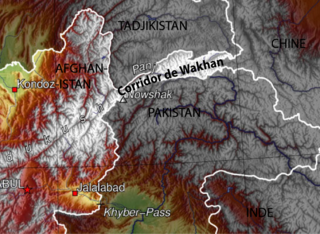
The Wakhan Corridor is a narrow strip of territory in the Badakhshan province of Afghanistan. This corridor stretches eastward, connecting Afghanistan to Xinjiang, China. It also separates the Gorno-Badakhshan Autonomous Region of Tajikistan in the north from the Khyber Pakhtunkhwa and Gilgit-Baltistan regions of Pakistan in the south, the latter of which is also part of the disputed region of Kashmir. This high mountain valley, which rises to a maximum altitude of 4,923 m (16,152 ft), serves as the source of both the Panj and Pamir rivers, which converge to form the larger Amu Darya River. For countless centuries, a vital trade route has traversed this valley, facilitating the movement of travelers to and from East, South, and Central Asia.

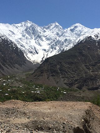
Terich Mir is the highest mountain of the Hindu Kush range, and the highest mountain in the world outside of the Himalayas–Karakoram range, at 7,708 meters (25,289 ft) above sea level. It is located in the Chitral District of Khyber Pakhtunkhwa, Pakistan.
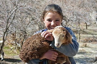
The Wakhi people, also locally referred to as the Wokhik, are an Iranian ethnic group native to Central and South Asia. They are found in Afghanistan, Tajikistan, Pakistan and China—primarily situated in and around Afghanistan's Wakhan Corridor, the northernmost part of Pakistan's Gilgit−Baltistan and Chitral, Tajikistan's Gorno−Badakhshan Autonomous Region and the southwestern areas of China's Xinjiang Uyghur Autonomous Region. The Wakhi people are native speakers of the Wakhi language, an Eastern Iranian language.

The Karakoram Highway, also known as the KKH, National Highway 35, N-35, and the China–Pakistan Friendship Highway, is a 1,300 km (810 mi) national highway which extends from Hasan Abdal in the Punjab province of Pakistan to the Khunjerab Pass in Gilgit-Baltistan, where it crosses into China and becomes China National Highway 314. The highway connects the Pakistani provinces of Punjab and Khyber Pakhtunkhwa plus Gilgit-Baltistan with China's Xinjiang Uyghur Autonomous Region. The highway is a popular tourist attraction and is one of the highest paved roads in the world, passing through the Karakoram mountain range, at 36°51′00″N75°25′40″E at maximum elevation of 4,714 m (15,466 ft) near Khunjerab Pass. Due to its high elevation and the difficult conditions under which it was constructed, it is often referred to as the Eighth Wonder of the World. The highway is also a part of the Asian Highway AH4.

Chitral District was a district in the Malakand Division of the Pakistani province of Khyber Pakhtunkhwa, from 14 August 1947 to 2018. It was the largest district in the Khyber-Pakhtunkhwa, covering an area of 14,850 km2, before splitting into Upper and Lower Chitral Districts in 2018. It was the northernmost district of Khyber Pakhtunkhwa. It shared a border with Gilgit-Baltistan to the east and with Swat and Dir districts of Khyber Pakhtunkhwa to the south. It also shared an international border with Afghanistan to the north and west. Afghanistan's narrow strip of Wakhan Corridor separated Chitral from Tajikistan in the north.

The Ghizer District, was a district in the westernmost part of the Gilgit-Baltistan province of Pakistan, before splitting into the current Ghizer and Gupis-Yasin districts in 2019. The capital of the district was Gahkuch.

Northern Pakistan is a tourism region in northern and north-western parts of Pakistan, comprising the administrative units of Gilgit-Baltistan, Azad Kashmir, Khyber Pakhtunkhwa, Islamabad Capital Territory and the Rawalpindi Division in Punjab. The first two territories are a part of the wider Kashmir region. It is a mountainous region straddling the Himalayas, Karakoram and the Hindu Kush mountain ranges, containing many of the highest peaks in the world and some of the longest glaciers outside polar regions. Northern Pakistan accounts for a high level of Pakistan's tourism industry.

Chitral is a city situated on the Chitral River in northern area of Khyber Pakhtunkhwa. It serves as the capital of the Lower Chitral District, and was previously the capital of Chitral District, and before that the capital of Chitral princely state. The region was encompassed into West Pakistan between the years 1969 and 1972. It has a population of 49,780 per the 2017 census.

Dorah Pass, also called Durah Pass, connects Badakshan Province of Afghanistan with Lower Chitral District in Khyber Pakhtunkhwa, Pakistan. The Dorah Pass is more than 14,000 feet (4,300 m) high. It is located along the Durand Line border and crosses the Hindu Kush mountain range. Situated at the foot of the pass is Lake Dufferin, also known locally as Hawz-i Dorah. The lake is roughly 2+3⁄4 miles (4.4 km) long by over one-quarter mile (0.4 km) broad.
Broghil, also spelled Broghol, elevation 3,798 metres (12,461 ft), is a high mountain pass along the Durand Line border that crosses the Hindu Kush mountain range and connects Wakhan District of Badakhshan Province, Afghanistan with Chitral District of Khyber Pakhtunkhwa, Pakistan.

Shandur Pass(Urdu: شندور) is a pass located on the boundary of district Chitral, Khyber Pakhtunkhwa, Pakistan and Gilgit-Baltistan, a disputed territory within the larger region of Kashmir. Historically part of Gilgit-Baltistan; however, recent Khyber Pakhtunkhwa governments have made claims for the Shandur. It is often referred to as 'The Roof of the World.

Yasin Valley is a high-altitude mountain valley nestled in the Hindu Kush mountain range, located in the northern region of the Gupis-Yasin District within Gilgit-Baltistan. The valley is situated approximately 148 kilometers from the city of Gilgit, which serves as the capital of Gilgit-Baltistan. Within the valley's territory lies Yasin Tehsil, an administrative subdivision of the region.

Gilgit-Baltistan is an administrative territory of Pakistan in the northern part of the country. It was given self-governing status on August 29, 2009. Gilgit-Baltistan comprises 14 districts within three divisions. The four districts of Skardu Kharmang Shigar and Ghanche are in the Baltistan Division, four districts of Gilgit Ghizer Hunza and Nagar districts which were carved out of Gilgit District are in the Gilgit Division and the third division is Diamir, comprising Chilas and Astore. The main political centres are the towns of Gilgit and Skardu.
Tourism in Pakistan is a growing industry. In 2010, Lonely Planet termed Pakistan "tourism's 'next big thing'". The country is geographically and ethnically diverse, and has a number of historical and cultural heritage sites. Condé Nast Traveller ranked Pakistan The Best Holiday Destination for 2020 and also declared it the third-highest potential adventure destination in the world for 2020. As security in the country improves, tourism increases; in two years, it has increased by more than 300%.

Gilgit-Baltistan, formerly known as the Northern Areas, is a region administered by Pakistan as an administrative territory and consists of the northern portion of the larger Kashmir region, which has been the subject of a dispute between India and Pakistan since 1947 and between India and China since 1959. It borders Azad Kashmir to the south, the province of Khyber Pakhtunkhwa to the west, the Wakhan Corridor of Afghanistan to the north, the Xinjiang region of China to the east and northeast, and the Indian-administered union territories of Jammu and Kashmir and Ladakh to the southeast.
Mastuj is a tehsil of Upper Chitral District in Khyber-Pakhtunkhwa province of Pakistan; Mastuj is the principal settlement. It is located at 36°17'0N 72°31'0E with an altitude of 2359 metres. There are ruins of old fort built originally in 18th century and reconstructed several times.

Tourism in Gilgit-Baltistan, an administered territory of Pakistan, focuses on its access to various mountain ranges and alpine terrain. Various tourist destinations attract millions of travelers from within Pakistan. On the other hand, tourists from other countries also routinely visit GB. An estimated 1.72 million tourists visited the region in 2017 according to the Pakistan Tourism Development Corporation (PTDC). Travelers had contributed Rs.300 million to the local economy in 2017. The authorities were expecting 2.5 million tourists in 2018 which would have meant an additional Rs.450 million to the economy.

Ghizer District is a district of Pakistan-administered Gilgit-Baltistan region in the disputed Kashmir region. It is one of the 14 districts of Gilgit-Baltistan. The former Ghizer District that existed from 1974 to 2019 spanned the entire upper Gilgit River Valley. In 2019, the former district was divided into the Gupis-Yasin District in the west and the present, smaller Ghizer District in the east.
It is situated in Koh e sufaid mountain ranges
Banu( Pakistan) to ghazni (Afghanistan)