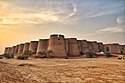
Mardan District is a district in the Mardan Division of the Khyber Pakhtunkhwa province of Pakistan. The district is named after Mardan city, which is also the headquarters of the district. The district is famous for its agriculture industry and its archaeological sites, specifically of Takht-i-Bhai, Jamal Garhi and Sawal Dher.
Dargai is one of the tehsils of Malakand District in Pakistan's northwestern Khyber Pakhtunkhwa province. It located on the main highway from Peshawar to Swat, Dir and Chitral.

Ghazi Khan Umra Khan of Jandol, also called "The Afghan Napoleon", was a Pashtun chief on the north-western frontier of British India, who was chiefly responsible for the Chitral Expedition of 1895. He was the Khan of Jandol and captured the state of Dir and reigned as its Nawab from 1890 to 1895. Umra briefly occupied Swat, Chitral and Bajaur. He also took over Kunar and Kafiristan regions of Afghanistan.
Chakdara (چکدرہ) is a city in the Lower Dir District of Khyber Pakhtunkhwa, Pakistan. It is the second largest city in Dir Lower after Timergara. It serves as a gateway of Malakand Division. It is located in the center of Malakand Division at the entrance of the Lower Dir District, also near the entrance of the Swat District. The Swat Expressway's Chakdara interchange touches this area. Chakdara is about 130 km far from Peshawar, 40km from Mingora and 38 km from Timergara.
Malakand Division is an administrative division of Khyber Pakhtunkhwa province of Pakistan. Malakand is the Fisrt largest Division by Population and Mingora is its capital which is 3rd largest city in Privance. CNIC code of Malakand Division is 15.

Dir was a princely state in a subsidiary alliance with the British Raj, located within the North-West Frontier Province. Following the Partition of British India, Dir remained independent and unaligned until February 1948, when the Dominion of Pakistan accepted its accession.

The Swat River is a perennial river in the northern region of the Khyber-Pakhtunkhwa Province of Pakistan. The river's source is in the high glacial valleys of the Hindu Kush mountains, where it then flows into the Kalam Valley before forming the spine of the wider Swat Valley.
Malakand District is a district in the Malakand Division of the Khyber Pakhtunkhwa province of Pakistan.

Lund Khwar, also Lundkhwar | Urdu: لوندخوڑ) and pronounced "/Lu:/+/nd/, /Kh/+/va'/+/r:/" is a historical village and union council of Takht Bhai Tehsil in Mardan District of Khyber-Pakhtunkhwa, Pakistan. It is located at 34°23'22 N 71°58'51 E, with an altitude of 371 metres. The name "Lund Khwar" literally means "the ever-flowing stream or brook". Origins of the founding of Lund Khwar are shrouded in mystery. Archaeological and historical evidences indicate the nook point towards the Gandharan era. Earliest written accounts of the village trace it back to 8th century, with the arrival of the Dilazak tribesmen and in 15th century, by the Khattak tribesmen of the Afghans. Currently, it is a major town near the entrance to the Malakand mountains. Alternatively, there is also a Lund Khwar in the Paktika Province of Afghanistan.
Rashakai is a small town located along the Nowshera-Mardan road, in Khyber-Pakhtunkhwa.
The Utmankhel is a Pashtun tribe present in Pakistan, with substantial numbers in Afghanistan. They lie between the Mohmands and the Ranizais of Swat, to the west and south-west of the junction of the Swat and Panjkora rivers. The Utmankhel mostly living in Malakand, Bajaur, Mohmand, Lower Dir, Mardan and Orakzai. The Utmankhel are Pashtuns, part of the Karlani tribal confederacy, who fought against British and Mughals emperors in Pakhtunkhwa. The British regarded the Utmankhel tribesmen as “warlike” peoples and one of the Martial Race. The Utmankhel are a tall, stout and fair race, but their dress and general customs have been assimilated by the neighboring peoples of Bajaur. Utmankhel speak the same dialect of Pashtu called Yousafzai Pashto.
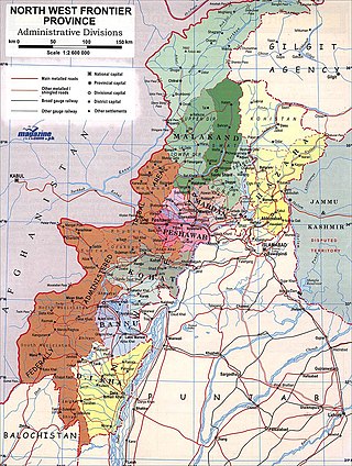
The Malakand Agency was one of the agencies in the North West Frontier Province of British India and later of Pakistan until 2010. It included the princely states of Chitral, Dir and Swat, and an area around the Malakand Pass known as the Malakand Protected Area. The largest city in the area was Mingora, while the three state capitals were Chitral, Dir, and Saidu Sharif. In 1970, following the abolition of the princely states, the agency became the Malakand Division, which was divided into districts, one of which was the Malakand Protected Area, known as Malakand District. In 2000 the Malakand Division was abolished. Despite the constitutional changes since 1970, the expression Malakand Agency is still used, sometimes of the entire area of the former Agency, but more often of Malakand District.

Batkhela is a city, tehsil and the district headquarter of the Malakand District within the Khyber Pakhtunkhwa province of Pakistan. According to the 2017 Census of Pakistan, the population of Batkhela was recorded at 68,200. Batkhela is considered as one of the most popular business cities in the Khyber Pakhtunkhwa province. A water canal that pours into a small dam in the Jabban area near Batkhela is the main source of electricity production here.

The Chitral Expedition was a military expedition in 1895 sent by the British authorities to relieve the fort at Chitral, which was under siege after a local coup following the death of the old ruler. An intervening British force of about 400 men was besieged in the fort until it was relieved by two expeditions, a small one from Gilgit and a larger one from Peshawar.
Mardan Cantonment is located in Mardan, the second largest city of Khyber Pakhtunkhwa, and is the only cantonment in Mardan District and Mardan Division. It is the centre of one of the most renowned regiment of Pakistan Army - The Punjab Regiment. The cantonment has a large area for training and offices. Mardan once served as a base for British troops, who never managed to fully control the region's Pashtun tribes. Now it is home to the Pakistan Air Force Academy, at the Risalpur air base; and the Pakistan Army's School of Artillery and School of Armor and Mechanized Warfare.

Thana is the biggest city of Malakand District. The name is derived from the Pashto word "Thanrha" which means "Place Of Courting", and was a main political center during the tribal period. The literacy Rate in the city is approximately 95% and the poverty rate is approx 24%. The nominal GDP of the city Thana is approx $690 million. The area is 230 km (140 mi) and the elevation is 950 metres (3,120 ft). The average snowfall is 2.3 cm (0.91 in).

The Dir Levies is a paramilitary force in the Dir District of the Pakistani province of Khyber Pakhtunkhwa. It operates as the primary law enforcement agency tasked with maintaining law and order within the division. The force has its origins back in the days of the British Raj, and has continued to function for over a century.
The Battle of Malakand pass took place in the Malakand Pass between a British expeditionary force commanded by Robert Low, a General of the British Indian Army against tribal Chitralis during the Chitral Expedition.