Batkhela

Last updated • 6 min readFrom Wikipedia, The Free Encyclopedia

Batkhela
بٹ خیلہ
بټ خېله
Lower Batkhela Canal (Nehar), Malakand Agency, KPK.JPG
Batkhela Canal flows through the city
Pakistan Khyber Pakhtunkhwa location map.svg
Red pog.svg
Batkhela
Location within Khyber Pakhtunkhwa
Pakistan location map.svg
Red pog.svg
Batkhela
Location within Pakistan
Coordinates: 34°37′N71°58′E / 34.62°N 71.97°E / 34.62; 71.97
CountryFlag of Pakistan.svg  Pakistan
Province Khyber Pakhtunkhwa
District Malakand
Tehsil Swat Rani Zai Tehsil
EstablishedMarch 1895 (British)
Government
  TypeTehsil, City
  Governing bodyUnion Council (3 Seats)
  AC/Sub divisional Magistrate/Deputy CommandantAun Haider (PAS)
  Tehsil NazimAdnan Ibrar (PMS)
  Upper BatkhelaFazal Wahid Lalagi (JI)
Area
   City 1,001 km2 (386 sq mi)
Elevation
648 m (2,126 ft)
Population
 (2023 census)
   Urban
73,525
Time zone UTC+5 (PST)
Website nwfp.gov.pk

Batkhela (Pashto : بټ خېله, Urdu : بٹ خیلہ) is a city, tehsil and the district headquarter of the Malakand District within the Khyber Pakhtunkhwa province of Pakistan. According to the 2017 Census of Pakistan, the population of Batkhela was recorded at 68,200. [1] Batkhela is considered as one of the most popular business cities in the Khyber Pakhtunkhwa province.[ citation needed ] A water canal that pours into a small dam in the Jabban area near Batkhela is the main source of electricity production here. [2]

Contents

Batkhela General Civil Headquarters Hospital is the main hospital of the district Malakand. Batkhela's main bazaar is more than 1.5 Kilometres long. [3] [4]

History

Etymology

During the Ashoka and Kanishka Empires, Batkhela was ruled by a leader named Butt. The name "Batkhela" is, hence, associated with his name.[ citation needed ]

Batkhela water canal Canal in Batkhela.jpg
Batkhela water canal
District Headquarters Hospital Batkhela OPD District Head Quarter Hospital Batkhela OPD.jpg
District Headquarters Hospital Batkhela OPD
District Headquarters Hospital Batkhela Casualty District Head Quarter Hospital Batkhela Casualty.jpg
District Headquarters Hospital Batkhela Casualty

Early history

Batkhela Rural side Malakand division.JPG
Batkhela Rural side

At the time when Mahmud of Ghazni (997-1030) was attacking India, one of his army leaders Pir Khushal assailed Batkhela. During the course of this assault, most of his soldiers were sunk in a big marsh at a place called Gheli in Batkhela. However, the soldiers of his army that survived had preferred to stay in this region. Over time, they put strong influence on the local inhabitants. They not only changed the culture and customs of them but also exerted a strong influence to convert them to Islam.[ citation needed ]

Amandara Head Works (water flow on floor) Amandara Head Works (Carpet water).jpg
Amandara Head Works (water flow on floor)

Early in the 17th century, an Afghan tribe called Yusufzai (Yusufzai Pathan) invaded the Swat region [5] under the leadership of Malik Ahmad Khan. During this period, Batkhela was part of the Swat Valley. At that time, Swat was ruled by a ruler named Raees. Swati tribe was a permanent inhabitant there. After the invasion, most of the Swati tribe's people left this area and escaped. It gave the Yusufzai tribe an opportunity to settle there permanently. Subsequently, they declared the Thana region (currently a part of the Batkhela tehsil) as their administrative headquarters.

In the beginning, three family classes of Yusufzai tribe were settled in Batkhela: Ibrahim Khel, Husain Khel and Nazrali Khel.

In March 1895, the British Empire invaded this region including Batkhela.[ citation needed ] Malak Mir Azam Khan of Ibrahim Khel was leading the army of Batkhela. A new political agency for Dir, Swat and Chitral was established. [6] The first officer to be placed in charge of the new Malakand Agency was Major Harold Arthur Deane(1854–1908). [7] [8] [9] [10] [11] Later on 9 November 1901, Lieutenant Colonel Sir Harold Arthur Deane also became the first Chief Commissioner on the formation of the North-West Frontier Province (now Khyber Pakhtunkhwa). [8] [10] [11] [12] [13]

Amandara Head Works (Batkhela Water Canal Bridge) Amandara Head Works (Batkhela Water Canal Bridge).jpg
Amandara Head Works (Batkhela Water Canal Bridge)

That year when Batkhela was stormed by the 45th Sikhs after a fierce resistance, Lieut.-Colonel McRae was the very first British Army personnel to enter Batkhela. [14] Before 1895, Batkhela was invaded by different outsiders including the Khan of Dir, Rahmatullah Khan, in 1869 and Wali-i-Dir Nawab Muhammad Umara Khan as well as the Swatis.[ citation needed ] On capturing Malakand Agency, the British Army decided to secure this area permanently from these outside aggressions. The British rulers declared this area as a 'Malakand Protected Area' (same as present). For that purpose, they prepared a police force called the Malakand Levies.[ citation needed ]

Between 1895 and 1912, the British made a huge impact on developmental works and infrastructure. They built roads from Batkhela to Chakdara, raised Chakdara and Malakand forts, set up Levies posts all over Malakand Agency, dug Upper Swat Canal and The Benton Tunnel (locally known as Tandail), constructed headwork's scheme at Batkhela, Churchill Paquet and Jabban Hydropower Station (Jabban Hydropower Plant). Beside those, the most important of all was the Amandara (region in Batkhela) Irrigation Scheme (bridges) which were designed and built by the British firm Ransomes & Rapier, Ltd. Makers of Ipswich in 1912. It is still irrigating a vast land of Sama Tehsil, Mardan and Swabi Districts and Chakdara area of the Lower Dir District.

The British ruled this area until the independence of Pakistan(1947). All the matters of the tribal system were settled through the ‘Jirga System'.[ citation needed ] The Frontier Crimes Regulation (FCR) system or status was established in 1974 here. Furthermore, regular laws prevailing and the settle laws of district were also extended. Under the FCR, the Political Agent exercised his powers as a supreme authority while regular courts were established (Civil & Crime courts) after the year 1974.

Governance

Police in district Malakand are known as Levies and their head or commandant is the Deputy Commissioner. The current Tehsil Nazim of Batkhela is Nasir Khan (Pakistan Tehreek-e-Insaf).

Geography

Batkhela is a green city and Swat River is flowing in the middle of the city alongside N45. Batkhela is covered by tall hills from all sides and the most of famous peak of them is named 'Barcharai'.

Batkhela water canal alongside the main G.T. road (N45) Batkhela water canal alongside the main G.T. road.jpg
Batkhela water canal alongside the main G.T. road (N45)

Division

Politically, Batkhela is divided into three union councils: upper, middle, and lower Batkhela.

Demography

According to the 6th Population & Housing Census 2017, the population of Batkhela was declared as 68,200. [1] Data on religious beliefs across the town in the 2017 census shows that 100% of its population has declared themselves to be Muslim. [15]

Population

The population of city in 1998 was 43,179 but according to the 2023 Census of Pakistan, the population has risen to 73,525. [16]

CensusPopulation
197214,945
199843,179
201767,686
202373,525
Batkhela Water Canal alongside N45 Water Canal alongside N45.jpg
Batkhela Water Canal alongside N45

People and culture

More than 95% of local residents are Pashtuns, who are the indigenous inhabitants of the region.

Education

The first primary school was opened in Batkhela in 1915 and a high school was opened in Thana (part of Batkhela tehsil) in 1935 by British rulers.[ citation needed ] At present, there is one degree college for boys, one degree college for girls, two secondary schools for boys and one higher secondary school for girls that are functioning. In addition, there are several private schools and colleges functioning throughout this region. All schools and colleges are affiliated with the Board of Intermediate & Secondary Education (BISE) Malakand.

Media

The District Press Club Malakand at Batkhela has been functional since 1988 in a rented building while reporters attached with the national, regional and local print and electronic media organizations have been performing their duties with devotion and sincerity. The former minister for information had approved funds for a well-equipped press club building at Batkhela during their term. The remaining funds were approved later on. The construction work on the building has been completed now. Soon, it will be inaugurated making the work of local journalists easier. The first-ever "monthly," the Hidayat Nama, was started by the late Muhammad Islam Ajmali who has been regarded as founder of journalism in the area. Later on, Mr. Amjad Ali Khan started his monthly Tasht from Batkhela that was closed after a few years. The Monthly 'Nazar' of Gohar Ali Gohar also closed after two years of circulation. Rab Nawaz Saghir started his 'Akas' that closed, too. Mr. Ihsan ur Rehman Sagar started a monthly Adrash which has been the first-ever declared newspaper from the area. It was made a weekly sometime later and then a daily newspaper, but was delisted by the KP Govt.

Related Research Articles

<span class="mw-page-title-main">Khyber Pakhtunkhwa</span> Province of Pakistan

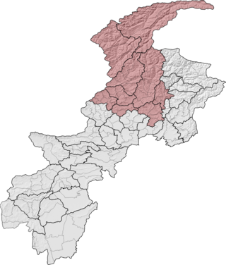
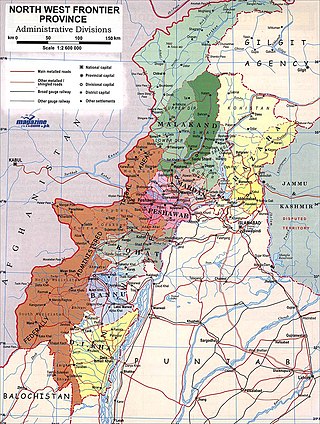
Khyber Pakhtunkhwa, formerly known as North West Frontier Province (NWFP), is a province of Pakistan. Located in the northwestern region of the country, Khyber Pakhtunkhwa is the fourth largest province of Pakistan by land area and the third-largest province by population. It is bordered by Balochistan to the south; Punjab, Islamabad Capital Territory, and Azad Kashmir to the east; and Gilgit-Baltistan to the north and northeast. It shares an international border with Afghanistan to the west. Khyber Pakhtunkhwa has a varied geography of rugged mountain ranges, valleys, rolling foothills, and dense agricultural farms.

Waziristan is a mountainous region of Pakistani province of Khyber Pakhtunkhwa. The Waziristan region administratively splits among three districts: North Waziristan, Lower South Waziristan District, and Upper South Waziristan District. Waziristan region, consisted of three districts, covers around 11,585 square kilometres (4,500 sq mi) and is mainly populated by the Mehsud, The Wolves, & Wazir Pashtun tribe, who speak the Waziri dialect of the Pashto language.

<span class="mw-page-title-main">Yusufzai</span> Pashtun tribe

The Yusufzai or Yousafzai, also referred to as the Esapzai, or Yusufzai Afghans historically, are one of the largest tribes of Pashtuns. They are natively based in the northern part of Khyber Pakhtunkhwa, to which they migrated from Kabul during the 16th century, but they are also present in parts of Afghanistan, including Kunar, Kabul, Kandahar and Farah. Outside of these countries, they can be found in Ghoriwala District Bannu, Balochistan Sibi (Akazai), Chagai (Hassanzai) and Rohilkandh.

<span class="mw-page-title-main">Mardan District</span> District in Khyber Pakhtunkhwa, Pakistan

Mardan District is a district in the Mardan Division of the Khyber Pakhtunkhwa province of Pakistan. The district is named after Mardan city, which is also the headquarters of the district. The district is famous for its agriculture industry and its archaeological sites, specifically of Takht-i-Bhai, Jamal Garhi and Sawal Dher.

Dargai is one of the tehsils of Malakand District in Pakistan's northwestern Khyber Pakhtunkhwa province. It located on the main highway from Peshawar to Swat, Dir and Chitral.

<span class="mw-page-title-main">Malakand Pass</span> Mountain pass in Pakistan

The Malakand Pass is a mountain pass in the Malakand District of Khyber Pakhtunkhwa that connects Peshawar with the Chitral District.

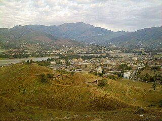
Chakdara (چکدرہ) is a city in the Lower Dir District of Khyber Pakhtunkhwa, Pakistan. It is the second largest city in Dir Lower after Timergara. It serves as a gateway of Malakand Division. It is located in the center of Malakand Division at the entrance of the Lower Dir District, also near the entrance of the Swat District. The Swat Expressway's Chakdara interchange touches this area. Chakdara is about 130 km far from Peshawar, 40km from Mingora and 38 km from Timergara.

<span class="mw-page-title-main">Dir District</span> Place in Pakistan

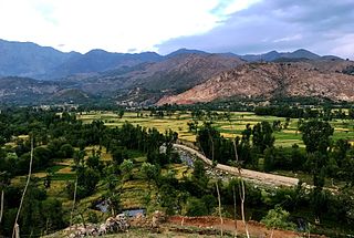
Dir is a region in northwestern Pakistan in the Khyber Pakhtunkhwa, in the foothills of the Himalayas. Before the independence of Pakistan, Dir was a princely state, and it remained so until 1969 when it was abolished by a presidential declaration, and the Dir District was created the following year. The area covers 5,280 square kilometres. In 1996 Dir district was officially divided into Lower Dir District and Upper Dir District.

<span class="mw-page-title-main">Malakand Division</span> Administrative division of Khyber Pakhtunkhwa, Pakistan

Malakand Division is an administrative division of Khyber Pakhtunkhwa province of Pakistan. Malakand is the Fisrt largest Division by Population and Mingora is its capital which is 3rd largest city in Privance. CNIC code of Malakand Division is 15.

<span class="mw-page-title-main">Lower Dir District</span> District of Khyber Pakhtunkhwa in Pakistan

Lower Dir District is a district in the Khyber Pakhtunkhwa province of Pakistan. Timergara is the district's headquarters and largest city. The Lower Dir district was formed in 1996, when Dir District was divided into Upper Dir and Lower Dir districts. On 22 January 2023, both Lower Dir and Upper Dir districts were further bifurcated to create a new Central Dir District. Lower Dir is famous for its beautiful snow-capped mountains, valleys, and pleasant weather. The primary industry in Lower Dir is tourism, which is now rapidly growing.

<span class="mw-page-title-main">Upper Dir District</span> District in Khyber Pakhtunkhwa, Pakistan

Upper Dir District is a district located in the Malakand Division of Khyber Pakhtunkhwa province of Pakistan. The city of Dir is its district headquarter. Geographically, it is located in the northern part of Pakistan. It borders with the Chitral district on the north, Afghanistan on the northwest, the Swat district on the east, and the Lower Dir district on the south. It shares 40 to 50 kilometers border with Afghanistan.

<span class="mw-page-title-main">Dir (princely state)</span> Princely state of British India and later Pakistan

Dir was a princely state in a subsidiary alliance with the British Raj, located within the North-West Frontier Province. Following the Partition of British India, Dir remained independent and unaligned until February 1948, when the Dominion of Pakistan accepted its accession.

<span class="mw-page-title-main">Bajaur District</span> District in Khyber Pakhtunkhwa, Pakistan

Bajaur District, formerly Bajaur Agency, is a district in the Malakand Division of Khyber Pakhtunkhwa Province, Pakistan. Prior to 2018, Bajaur Agency was the northernmost component of the Federally Administered Tribal Areas (FATA), a semi-autonomous region along the Afghanistan–Pakistan border. In May 2018, FATA was merged into the larger Khyber Pakhtunkhwa Province (KPK) in an attempt to bring stability to the region, redesignating Bajaur Agency to Bajaur District.

<span class="mw-page-title-main">Malakand District</span> District of Khyber Pakhtunkhwa in Pakistan

Malakand District is a district in the Malakand Division of the Khyber Pakhtunkhwa province of Pakistan.

Bara Bandai is a village in Swat, Khyber Pakhtunkhwa, Pakistan, known as an area crossed by Alexander The Great during his invasion of the subcontinent. The people of village Bara Bandai belong to subsection Naikpikhel of Yusufzai the biggest and largest tribe of Pashtun or Pakhtun tribes. It is one of the Provincially Administered Tribal Areas (PATA) of Pakistan. The village contains a small series of mountains and a forest, residential area starting from meadows of mountainsand merge with river swat on right bank, a village market, vast land for crops, number of canals, and a part of the Swat river. Mountains of the village include Usmani Sar, Kafar Ghat and Najia Top.

<span class="mw-page-title-main">Malakand Agency</span> Administrative division of British India and later Pakistan

The Malakand Agency was one of the agencies in the North West Frontier Province of British India and later of Pakistan until 2010. It included the princely states of Chitral, Dir and Swat, and an area around the Malakand Pass known as the Malakand Protected Area. The largest city in the area was Mingora, while the three state capitals were Chitral, Dir, and Saidu Sharif. In 1970, following the abolition of the princely states, the agency became the Malakand Division, which was divided into districts, one of which was the Malakand Protected Area, known as Malakand District. In 2000 the Malakand Division was abolished. Despite the constitutional changes since 1970, the expression Malakand Agency is still used, sometimes of the entire area of the former Agency, but more often of Malakand District.

<span class="mw-page-title-main">Kuza Bandai</span> Union Council & village in Khyber Pakhtunkhwa, Pakistan

Kuza Bandai is a well developed village in Swat Valley of Khyber Pakhtunkhwa, Pakistan. It is known for its natural environment and also known as an area crossed by Alexander the Great. Later, after the Lal Masjid battle, Kuza Bandai and Bara Bandai became sympathetic to the Taliban movement. The village consists of Yusufzai Pakhtun tribes. It is one of Pakistan's Provincially Administered Tribal Areas (PATA).

<span class="mw-page-title-main">Dara Utmankhel</span>

Dara Utmankhel, also known as Shaikhan, is a valley in the Lower Dir District of Khyber Pakhtunkhwa, Pakistan. It consists of nine villages: Maniband ما نی بند, Jabaghi جبګۍ, Zara Doghy زړه ډوګۍ, Kot Koshah کوټ کو شاه, Mandal Korona کورونه ماندل, Kot کوټ, Ghwandy غونډئ, Fazal Abad and Shah Kuronu شاه کو رونه. It lies in Timergara tehsil, east of the main road from Timergara to Dir. The inhabitants of this area belong to the Mandal, a clan of Utmankhel tribe of Pashtuns. The Utmankhel is one of the Karlanri Pashtun or Afghan tribes who appeared in concert with other tribes like Yousafzai and Tarkalani. They first settled in the areas of Malakand, Bajaur and Mohmand. These people were mainly associated with trade as the land was not suitable for agriculture.

<span class="mw-page-title-main">Manglawar</span> Union council in Khyber-Pakhtunkhwa, Pakistan

Manglawar is an administrative unit, known as Union council of Tehsil Babuzai, of Swat District in the Khyber Pakhtunkhwa province of Pakistan and former capital of Kingdom of Swat. It is located at 34°48'30.7"N 72°25'50.0"E with an average altitude of 987 meters.

References

  1. 1 2 "Archived copy". Archived from the original on 7 May 2020. Retrieved 4 July 2020.{{cite web}}: CS1 maint: archived copy as title (link)
  2. https://www.graana.com/blog/batkhela-a-hidden-treasure-in-malakand-valley/
  3. Malakand District: socio-political profile = Pattan Development Organization. Islamabad. 2006. LCCN   2007379799.{{cite book}}: CS1 maint: location missing publisher (link)
  4. Mohammad Nawaz Khan (1995). Malakand: A journey through history. Gandhara Markaz. p. 12. ASIN   B0006FBFNK.
  5. Horace Arthur Rose; Sir Denzil Ibbetson & Sir Edward Douglas Maclagan (2006). Glossary of the Tribes and Castes of the Punjab and North West Frontier Province. Asian Educational Services, India. p. 125. ISBN   8120605055.
  6. Donald Sydney Richards (2002). Pakistan The Savage Frontier: A History of the Anglo-Afghan Wars. Pan Books. p. 128. ISBN   0330420526.
  7. Rizwan Hussain (2005). Pakistan and the Emergence of Islamic Militancy in Afghanistan. Ashgate. p. 36. ISBN   0754644340.
  8. 1 2 Bankey Bihari Misra (1991). The Unification and Division of India. OUP India. p. 128. ISBN   019562615X.
  9. Charles Miller (1977). KHYBER British India's North West Frontier The Story of an Imperial Migraine. McDonald and James. p.  287. ISBN   0025848607.
  10. 1 2 Sir Olaf Kirkpatrick Caroe (1976). The Pathans: 550 B.C.-A.D. 1957. OUP Pakistan. p. 386. ISBN   0195772210.
  11. 1 2 Victoria Schofield (2003). Afghan Frontier: Feuding and Fighting in Central Asia. Tauris Parke Paperbacks. p. 145. ISBN   1860648959.
  12. Roger Edward Francis Guilford North (1946). The literature of the North-West Frontier of India: A select bibliography. the University of California. p. 08. OCLC   3131354.
  13. John F. Riddick (2006). The History of British India: A Chronology . Praeger Publishers Inc. p.  87. ISBN   0313322805.
  14. Winston Churchill (2007). The Story of The Malakand Field Force. Standard Publications, Inc. p. 60. ISBN   978-1604245486.
  15. "Archived copy". Archived from the original on 10 January 2019. Retrieved 4 July 2020.{{cite web}}: CS1 maint: archived copy as title (link)
  16. "Bat Khela (Malakand Protected Area, Khyber Pakhtunkhwa, Pakistan) - Population Statistics, Charts, Map, Location, Weather and Web Information". www.citypopulation.de. Retrieved 5 September 2024.