Related Research Articles

Charleston is the most populous city in the U.S. state of South Carolina, the county seat of Charleston County, and the principal city in the Charleston metropolitan area. The city lies just south of the geographical midpoint of South Carolina's coastline on Charleston Harbor, an inlet of the Atlantic Ocean formed by the confluence of the Ashley, Cooper, and Wando rivers. Charleston had a population of 150,277 at the 2020 census. The 2020 population of the Charleston metropolitan area, comprising Berkeley, Charleston, and Dorchester counties, was 799,636 residents, the third-largest in the state, 8th-largest in the Deep South and the 74th-largest metropolitan statistical area in the United States.

Fort Sumter is a sea fort built on an artificial island near Charleston, South Carolina to defend the region from a naval invasion. It was built after British forces captured and occupied Washington during the War of 1812 via a naval attack. The fort was still incomplete in 1861 when the Battle of Fort Sumter occurred, sparking the American Civil War. It was severely damaged during the battle and left in ruins. Although there were some efforts at reconstruction after the war, the fort as conceived was never completed. Since the middle of the 20th century, Fort Sumter has been open to the public as part of the Fort Sumter and Fort Moultrie National Historical Park, operated by the National Park Service.

Charleston County is located in the U.S. state of South Carolina along the Atlantic coast. As of the 2020 census, the population was 408,235, making it the third most populous county in South Carolina. Its county seat is Charleston. It is also the largest county in the state by land area. The county was created in 1800 by an act of the South Carolina State Legislature.

Berkeley County is a county in the U.S. state of South Carolina. As of the 2020 census, its population was 229,861. Its county seat is Moncks Corner, and the largest city is Goose Creek. After two previous incarnations of Berkeley County, the current county was created in 1882. Berkeley County is included in the Charleston-North Charleston, SC Metropolitan Statistical Area.

Mount Pleasant is a large suburban town in Charleston County, South Carolina, United States. In the Lowcountry, it is the fourth most populous municipality and largest town in South Carolina, and for several years was one of the state's fastest-growing areas, doubling in population between 1990 and 2000. The population was 90,801 at the 2020 census. It is part of the Charleston metropolitan area.

Sullivan's Island, historically known as O'Sullivan's Island, is a town and island in Charleston County, South Carolina, United States, at the entrance to Charleston Harbor, with a population of 1,791 at the 2010 census, and 1,891 people in 2020. The town is part of the Charleston metropolitan area, and is considered a very affluent suburb of Charleston.

North Charleston is a city in Berkeley, Charleston, and Dorchester counties within the U.S. state of South Carolina. As of the 2020 census, North Charleston had a population of 114,852, making it the 3rd most populous city in the state, and the 248th most populous city in the United States. North Charleston is a principal city within the Charleston-North Charleston, SC Metropolitan Statistical Area, which had a population of 799,636 in 2020.

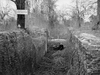
Fort Moultrie is a series of fortifications on Sullivan's Island, South Carolina, built to protect the city of Charleston, South Carolina. The first fort, formerly named Fort Sullivan, built of palmetto logs, inspired the flag and nickname of South Carolina, as "The Palmetto State". The fort was renamed for the U.S. patriot commander in the Battle of Sullivan's Island, General William Moultrie. During British occupation, in 1780–1782, the fort was known as Fort Arbuthnot.

Fort Sumter and Fort Moultrie National Historical Park is a United States National Historical Park located in Charleston County, in coastal South Carolina. It mainly protects Fort Sumter, Fort Moultrie, the Charleston Light and Liberty Square. It was known as Fort Sumter National Monument until it was renamed in the John D. Dingell Jr. Conservation, Management, and Recreation Act, signed March 12, 2019.
The Santee Canal was one of the earliest canals built in the United States. It was built to provide a direct water route between Charleston and Columbia, the new state capital of South Carolina. It was named to the National Register of Historic Places in 1982.

West Ashley, or more formally, west of the Ashley, is one of the six distinct areas of the city proper of Charleston, South Carolina. As of July 2022, its estimated population was 83,996. Its name is derived from the fact that the land is west of the Ashley River.

The Nathaniel Russell House is an architecturally distinguished, early 19th-century house at 51 Meeting Street in Charleston, South Carolina, United States. Built in 1808 by wealthy merchant and slave trader Nathaniel Russell, it is recognized as one of the United States' most important neoclassical houses. It was designated a National Historic Landmark in 1973.

Hanover House is a colonial house built by a French Huguenot family in 1714–1716, on the upper Cooper River in present-day Berkeley County of the South Carolina Low Country. The house is also known as the St. Julien-Ravenel House after its early owners.

The Battle of Sullivan's Island or the Battle of Fort Sullivan was fought on June 28, 1776, during the American Revolutionary War. It took place near Charleston, South Carolina, during the first British attempt to capture the city from American forces. It is also sometimes referred to as the first siege of Charleston, owing to a more successful British siege in 1780.
David Burns Hyer was an American architect who practiced in Charleston, South Carolina and Orlando, Florida during the first half of the twentieth century, designing civic buildings in the Neoclassical Revival and Mediterranean Revival styles.

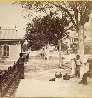
The history of Charleston, South Carolina, is one of the longest and most diverse of any community in the United States, spanning hundreds of years of physical settlement beginning in 1670. Charleston was one of leading cities in the South from the colonial era to the Civil War in the 1860s. The city grew wealthy through the export of rice and, later, sea island cotton and it was the base for many wealthy merchants and landowners. Charleston was the capital of American slavery.

Edward Culliatt Jones was an American architect from Charleston, South Carolina. A number of his works are listed on the U.S. National Register of Historic Places, and two are further designated as U.S. National Historic Landmarks. His works include the following :
Moultrie Playground is a public park in Charleston, South Carolina.
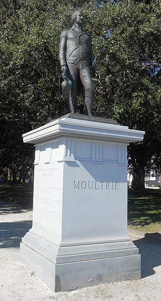
The William Moultrie statue is a monumental statue in Charleston, South Carolina, United States. Located in White Point Garden, the statue was unveiled in 2007 and honors William Moultrie, a general in the American Revolutionary War.
References
- ↑ Cameron, Louisa Pringle (15 April 2018). Charleston: City of Gardens. Univ of South Carolina Press. ISBN 9781611178197 – via Google Books.
- ↑ "Charleston, SC - Official Website - Grounds Maintenance Division". www.charleston-sc.gov.