Waterfront Park (Charleston)

Last updated
Waterfront Park
Charleston-SC-pineapple-fountain.jpg
Waterfront Park (Charleston)
Location Charleston, South Carolina
Coordinates 32°46′41″N79°55′31″W / 32.77806°N 79.92528°W / 32.77806; -79.92528
Area12 acres (4.9 ha)
Created1990 (1990)

Waterfront Park is an eight-acre (5 ha) park along approximately one-half mile of the Cooper River in Charleston, South Carolina. The park received the 2007 Landmark Award from the American Society of Landscape Architects and the National Trust for Historic Preservation. This award "recognizes a distinguished landscape architecture project completed between 15 and 50 years ago that retains its original design integrity and contributes significantly to the public realm of the community in which it is located." [1]

Contents

History

The location of the park, between Vendue Range to the north and Adger's Wharf to the south, had historically been a center of maritime traffic with several wharves and shipping terminals. The area entered a long period of decline, capped in June 1955 by a fire at a steamship terminal at the site. By 1980, the site was an "overgrown area marred by charred pilings and gravel parking lots." [2]

Mayor Joseph P. Riley Jr. began making plans for a park on the site soon after taking office in 1975. Acquisition of land began in 1979, and after more than a decade of planning, fund-raising and clearing environmental hurdles, the parks department and Ruscon Construction Co. broke ground in 1988. Work on the $13 million park progressed into 1989, and a target opening date was set for May 4, 1990. In September 1989, Hurricane Hugo struck, causing about $1 million of damage to the park. Nevertheless, the park opened on May 11, just one week past the pre-hurricane projection. [3]

Design

The park was designed by Stuart O. Dawson of Sasaki Associates with assistance from Edward Pinckney Associates and has received many design awards. The park is composed of distinct sections. At the northern entrance to the park at the foot of Vendue Range (a street in Charleston), a large fountain was built which anchors the end of the park. From the fountain, Vendue Wharf is a wide, wooden pier which extends into the Cooper River and offers sheltered swings. A floating dock is attached at the far end and provides unobstructed views of the Ravenel Bridge, Charleston Harbor, Castle Pinckney, the U.S.S. Yorktown at Patriot's Point, and Fort Sumter. The pier extends into the river approximately the same length as the Tidewater Terminals, Inc. facility had, and its charred pilings from the 1955 fire are still visible.

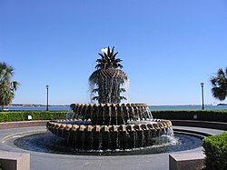
The largest portion of the park, between Vendue Range to the north and Exchange St. to the south, is itself made of two distinct sections. Running along Concord St. and Prioleau St. for approximately one-quarter mile is a dense canopy of oak trees and many benches. Parallel the shady urban park and immediately adjacent to the riverfront is an open lawn landscaped with palmetto trees. The 1,200 foot palmetto lined esplanade follows the natural water line ensuring public access to the water's edge. In the middle of the grassy lawn is the Pineapple Fountain, a large fountain shaped like a pineapple located immediately in front of the City Gallery.

At the southern end of the park, the formal esplanade follows the curve of the shore and turns back toward Concord Street. At Exchange Street, the park merges into restored salt marshes, creating valuable maritime habitat. Pedestrians can walk to the edge of the river at this point from Exchange Street to North Adger's Wharf. At the riverfront end of North Adger's Wharf, the 17th century pier was rebuilt in the original footprint with the original granite which was fished out of the river and reused. The pier was reconstructed using log cribbing construction of native palmetto trees to last for many generations. The pier marks the southern edge of the park.

Related Research Articles

<span class="mw-page-title-main">Sullivans Cove</span> Cove in Hobart, Tasmania, Australia

Sullivans Cove is on the River Derwent adjacent to the Hobart City Centre in Tasmania. It was the site of initial European settlement in the area, and the location of the earlier components of the Port of Hobart.

<span class="mw-page-title-main">Toronto Harbour</span> Bay on the north shore of Lake Ontario, in Toronto, Ontario, Canada

Toronto Harbour or Toronto Bay is a bay on the north shore of Lake Ontario, in Toronto, Ontario, Canada. It is a natural harbour, protected from Lake Ontario waves by the Toronto Islands. Today, the harbour is used primarily for recreational boating, including personal vessels and pleasure boats providing scenic or party cruises. Ferries travel from docks on the mainland to the Islands, and cargo ships deliver aggregates and raw sugar to industries located in the harbour. Historically, the harbour has been used for military vessels, passenger traffic and cargo traffic. Waterfront uses include residential, recreational, cultural, commercial and industrial sites.

<span class="mw-page-title-main">Tom McCall Waterfront Park</span> Public park in Portland, Oregon, U.S.

Governor Tom McCall Waterfront Park is a 36.59-acre (148,100 m2) park located in downtown Portland, Oregon, along the Willamette River. After the 1974 removal of Harbor Drive, a major milestone in the freeway removal movement, the park was opened to the public in 1978. The park covers 13 tax lots and is owned by the City of Portland. The park was renamed in 1984 to honor Tom McCall, the Oregon governor who pledged his support for the beautification of the west bank of the Willamette River—harkening back to the City Beautiful plans at the turn of the century which envisioned parks and greenways along the river. The park is bordered by RiverPlace to the south, the Steel Bridge to the north, Naito Parkway to the west, and Willamette River to the east. In October 2012, Waterfront Park was voted one of America's ten greatest public spaces by the American Planning Association.

<span class="mw-page-title-main">Exchange Place, Jersey City</span> Commercial district in Hudson County, New Jersey, US

<span class="mw-page-title-main">Port of San Francisco</span> Organization that oversees port facilities in San Francisco, California, United States

The Port of San Francisco is a semi-independent organization that oversees the port facilities at San Francisco, California, United States. It is run by a five-member commission, appointed by the Mayor and approved by the Board of Supervisors. The Port is responsible for managing the larger waterfront area that extends from the anchorage of the Golden Gate Bridge, along the Marina district, all the way around the north and east shores of the city of San Francisco including Fisherman's Wharf and the Embarcadero, and southward to the city line just beyond Candlestick Point. In 1968, the State of California, via the California State Lands Commission for the State-operated San Francisco Port Authority, transferred its responsibilities for the Harbor of San Francisco waterfront to the City and County of San Francisco / San Francisco Harbor Commission through the Burton Act AB2649. All eligible State port authority employees had the option to become employees of the City and County of San Francisco to maintain consistent operation of the Port of San Francisco.

<span class="mw-page-title-main">Allegheny Riverfront Park</span>

Allegheny Riverfront Park is a municipal park that runs along the south bank of the Allegheny River in Downtown Pittsburgh.

<span class="mw-page-title-main">Charles River Reservation</span>

The Charles River Reservation is a 17-mile-long (27 km) urban preserve and public recreation area located along the banks of the Charles River in Boston, Cambridge, Watertown, and Newton, Massachusetts. The reservation is managed by the Massachusetts Department of Conservation and Recreation.

<span class="mw-page-title-main">Riverfront Plaza/Belvedere</span>

<span class="mw-page-title-main">Hudson River Waterfront Walkway</span> Park in the United States of America

The Hudson River Waterfront Walkway, also known as the Hudson River Walkway, is a promenade along the Hudson Waterfront in New Jersey. The ongoing and incomplete project located on Kill van Kull and the western shore of Upper New York Bay and the Hudson River was implemented as part of a New Jersey state-mandated master plan to connect the municipalities from the Bayonne Bridge to the George Washington Bridge with an urban linear park and provide contiguous unhindered access to the water's edge.

<span class="mw-page-title-main">Three Rivers Park</span>

Three Rivers Park is a public urban waterfront park along the Allegheny, Monongahela, and Ohio Rivers in Pittsburgh, Pennsylvania.

<span class="mw-page-title-main">North Shore Riverfront Park</span>

<span class="mw-page-title-main">Jacksonville Riverwalks</span>

The Jacksonville Riverwalks are a network of multi-use trails and open space developments along both the north and south banks of the St. Johns River in Jacksonville, Florida. The roughly 2-mile (3.2 km) Downtown Northbank portion travels alongside the Hyatt Regency Jacksonville, Jacksonville Landing, Times-Union Center for the Performing Arts, CSX Transportation Building, and extends into the Brooklyn district. The 1.25-mile (2.01 km) Southbank portion of the trail connects local landmarks such as Friendship Fountain, Museum of Science and History and Riverplace Tower.

<span class="mw-page-title-main">Toronto Harbour Commission</span>

The Toronto Harbour Commission (THC) was a joint federal-municipal government agency based in Toronto, Ontario, Canada. The agency managed Toronto Harbour as well as being responsible for major works along the Toronto waterfront. It built both Malton Airport and the Toronto Island Airport in 1939. The agency was founded in 1911 and operated until 1999 when the port operations were transferred to the new Toronto Port Authority (TPA), now PortsToronto.

<span class="mw-page-title-main">Central Waterfront, Seattle</span> Neighborhood in Seattle

The Central Waterfront of Seattle, Washington, United States, is the most urbanized portion of the Elliott Bay shore. It runs from the Pioneer Square shore roughly northwest past Downtown Seattle and Belltown, ending at the Broad Street site of the Olympic Sculpture Park.

<span class="mw-page-title-main">Special routes of U.S. Route 52</span>

Several special routes of U.S. Route 52 exist, from North Dakota to South Carolina. In order from northwest to southeast, they are as follows.

<span class="mw-page-title-main">East River Greenway</span> Esplanade in Manhattan, New York

The East River Greenway is an approximately 9.44-mile-long (15.19 km) foreshoreway for walking or cycling on the east side of the island of Manhattan on the East River. It is part of the Manhattan Waterfront Greenway. The largest portions are operated by the New York City Department of Parks and Recreation. It is separated from motor traffic, and many sections also separate pedestrians from cyclists. The greenway is parallel to the Franklin D. Roosevelt East River Drive for a majority of its length.

<span class="mw-page-title-main">Chicago Riverwalk</span>

The Chicago Riverwalk is a multi-use public space located on the south bank of the main branch of the Chicago River in Chicago, extending from Lake Michigan and DuSable Lake Shore Drive westward to Lake Street. The Chicago Riverwalk contains restaurants, bars, cafes, small parks, boat and kayak rentals, a Vietnam War memorial, and other amenities. Its final extent will be beyond Wolf Point Towers, northward to the planned Bally's casino near the intersection of Chicago Avenue and Halsted Street.

<span class="mw-page-title-main">Pier 42 (East River)</span> Pier in Manhattan, New York

Pier 42 is a pier in the Lower East Side of Manhattan, New York City. It was the last working cargo pier on the Manhattan shore of the East River, operating from 1963 to 1987. Since the early 2010s, plans have been underway to turn Pier 42 into a park.

<span class="mw-page-title-main">Sasaki (company)</span>

Sasaki is a design firm specializing in Architecture, Interior Design, Urban Design, Space Planning, Landscape Architecture, Ecology, Civil Engineering, and Place Branding. The firm is headquartered in Boston, Massachusetts, but practices on an international scale, with offices in Shanghai, and Denver, Colorado, and clients and projects globally.

<span class="mw-page-title-main">Little Island at Pier 55</span> Park in Manhattan, New York

Little Island at Pier 55 is an artificial island park in the Hudson River west of Manhattan in New York City, adjoining Hudson River Park. Designed by Heatherwick Studio, it is near the intersection of West Street and West 13th Street in the Meatpacking District and Chelsea neighborhoods of Manhattan. It is located slightly west of the Manhattan shoreline atop Hudson River Pier 55, connected to Hudson River Park in Manhattan by footbridges at 13th and 14th Streets. Little Island has three concession stands, a small stage, and a 687-seat amphitheater.

References

  1. "404 File Not Found - ASLA".{{cite web}}: Cite uses generic title (help)
  2. Jonathan Poston, The Buildings of Charleston 152-53 (1997).
  3. http://archives.postandcourier.com/archive/arch00/0500/arc0525258099.shtml [ dead link ]