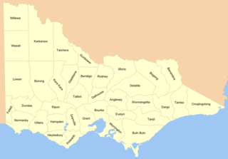
Cadastral divisions in Victoria are called counties, which are further subdivided into parishes and townships, for cadastral or land administration purposes. Cadastral divisions of county, parish and township form the basis for formal identification of the location of any piece of land in the state. There are 37 counties and 2004 parishes and 909 townships. Parishes were subdivided into sections of various sizes for sale as farming allotments, or designated as a town and then divided into sections and these subdivided into crown allotments. However, many parishes do not follow county borders, some being located in more than one county.

Birchip is a town in the Mallee region of Victoria, Australia on the Sunraysia Highway north of Donald. The town is located in the Shire of Buloke local government area. At the 2021 census, Birchip had a population of 694, down from the 2016 figure of 702. It has a P-12 school, and an Australian rules football club called Birchip-Watchem, also known as the Birchip-Watchem Bulls, or just the "Bulls".

Blinman is a locality incorporating two towns located in the Australian state of South Australia within the Flinders Ranges about 425 kilometres (264 mi) north of the state capital of Adelaide. It is very small but has the claim of being the highest surveyed town in South Australia. It serves as a base for large acre pastoralists and tourism. The town is just north of the Flinders Ranges National Park, is 60 kilometres north of Wilpena Pound.
The lands administrative divisions of Western Australia refer to subdivisions of the state of Western Australia for cadastral purposes, most of which have been in place since the 19th century. The state is divided up for this purpose into five land divisions, which in turn are subdivided into land districts, which correspond to counties in other Australian states. These districts are then subdivided further into numbered locations, as well as gazetted townsites. Together, they form part of the lands administrative divisions of Australia.
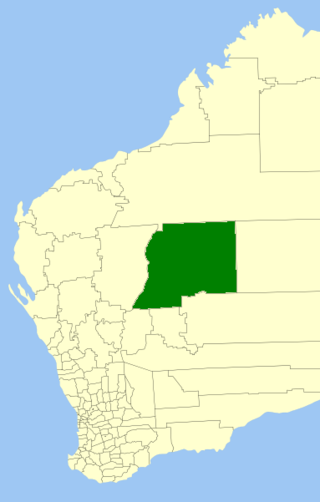
The Shire of Wiluna is a local government area in the Goldfields-Esperance region of Western Australia, about 950 kilometres (590 mi) northeast of the state capital, Perth. The Shire covers an area of 182,155 square kilometres (70,330 sq mi), and its seat of government is the town of Wiluna.
Victoria River is a locality in the Northern Territory of Australia located about 450 kilometres (280 mi) south of the territory capital of Darwin and about 240 kilometres (150 mi) south of the municipal seat in Katherine.
Etadunna is a locality in the Australian state of South Australia located about 684 kilometres north of the capital city of Adelaide and about 108 kilometres north-east of the town of Marree.
The County of Bosanquet is a cadastral unit in the Australian state of South Australia that covers land both in the north of the Eyre Peninsula and to the peninsula's north. It was proclaimed on 23 October 1913 and was named after Sir Day Hort Bosanquet, the Governor of South Australia from 1909 to 1914.
Tilley Swamp is a locality in the Australian state of South Australia located in the state's south-east about 199 kilometres (124 mi) south-east of the state capital of Adelaide and about 55 kilometres (34 mi) north of the municipal seat of Kingston SE. The 2016 Australian census, which was conducted in August 2016, reports that the area had a population of 27 people.
Western Flat is a locality in the Australian state of South Australia located in the state's south-east within the Limestone Coast region about 264 kilometres (164 mi) south east of the state capital of Adelaide and about 22 kilometres (14 mi) south of the municipal seat of Bordertown.
Woolundunga is a locality in the Australian state of South Australia located on the western side of the Flinders Ranges about 271 kilometres (168 mi) north of the state capital of Adelaide and about 21 kilometres (13 mi) south-east of the city of Port Augusta.
Tablelands is a locality in the Northern Territory of Australia located about 858 kilometres (533 mi) south-east of the territory capital of Darwin.
Allandale Station is a locality in the Australian state of South Australia located about 848 kilometres (527 mi) north of the state capital of Adelaide and about 20 kilometres (12 mi) south-east of the town of Oodnadatta.
Delamere is a locality in the Northern Territory of Australia about 369 kilometres (229 mi) south of the territory capital of Darwin.
Buchanan is a locality in the Northern Territory of Australia located in the territory's west adjoining the border with the state of Western Australia about 612 kilometres (380 mi) south of the territory capital of Darwin and about 473 kilometres (294 mi) south-west of the municipal seat in Katherine.
Baines is a locality in the Northern Territory of Australia located in the territory's west adjoining the border with the state of Western Australia about 421 kilometres (262 mi) south of the territory capital of Darwin and about 359 kilometres (223 mi) south-west of the municipal seat in Katherine.
Davenport is a locality in the Northern Territory of Australia located about 1,057 kilometres (657 mi) south of the territory capital of Darwin.
Gurindji is a locality in the Northern Territory of Australia located about 459 kilometres (285 mi) south of the territory capital of Darwin.
Richmond–Croydon Road is a continuous 360 kilometres (220 mi) road route in the Richmond, Croydon and Etheridge local government areas of Queensland, Australia. It is part of the shortest route from the Croydon / Georgetown area to Winton and Longreach. It is also part of the inland freight network linking cattle properties to major freight routes on the Landsborough and Flinders highways.
