List
| Image | Locality | Size | Year | Coordinates | Description | Source |
|---|---|---|---|---|---|---|
 | Brabrand Lake and Aarhus River Valley Including Brabrand Lake, Årslev Engsø and parts of Aarhus River Valley | 521 hectare | 1959, 1983, 1984 and 2001 | 56°08′34″N10°03′58″E / 56.142844°N 10.066017°E | Landscape, rich fen habitat and locally endangered species. Natura 2000, EU Habitats area | Ref 1, Ref 2 |
| Skæring Bæk and Skæring Strand | Ref | |||||
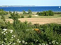 | Egå stream, Åkrogen and Vejlby Strand | 1918, 1926, 1956 and 1961 | 56°12′24″N10°17′06″E / 56.206541°N 10.285059°E | River mouth and beach | Ref | |
| Grevelund | 1967 | 56°16′00″N10°20′18″E / 56.266625°N 10.338323°E | Landscape (fields, woodland and beach habitats) | Ref | ||
| Mariendal | 2.3 hectare | 1959, 1964 | 56°03′03″N10°15′23″E / 56.050794°N 10.256423°E | Landscape | Ref | |
 | Parts of Marselisborg Forests Including the stream of Giber Å, Enemærket forest and wetland habitat, and the hills of Skåde Havbakker | 168 hectares | 56°05′40″N10°14′41″E / 56.094311°N 10.244757°E | Forest, meadow, wetland and river habitats. Coastal cliffs. Northern crested newt and otter. Natura 2000 | [2] | |
 | Fulden Fredningen Including Fulden and Moesgård | 1932, 1943, 1959, 1979 | Historical rural landscapes and nature, including a village, historic manor and estate. | Ref | ||
 | Holme Bjerge | 124 hectare | 1967 | Landscape | Ref | |
| Harlev Fredningen Including the forests of Stjær Stenskov and Lillering Forest | 220 hectare (a small part in Skanderborg Municipality) | 1962, 2017 | 56°08′00″N9°58′31″E / 56.133225°N 9.975215°E | Glacial stone deposit, ancient woodland, special wetland habitats, and historical ridge and furrows. Natura 2000 since 2017 | Ref, [3] | |
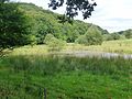 | Jeksendalen | 746 hectare (mostly in Skanderborg Municipality) | 1979 | 56°06′50″N9°59′47″E / 56.113781°N 9.996422°E | Landscape of both historical and biological importance (woodlands, streams and wet meadow habitats) | Ref |
 | Aarhus Botanical Gardens | 2017 | 56°09′38″N10°11′27″E / 56.16056°N 10.19083°E | City park | Ref | |
| | Stilling-Solbjerg Lake and Pilbrodalen | mostly in Skanderborg Municipality | 56°02′38″N10°03′50″E / 56.043851°N 10.063952°E | Lake habitat and glacial valley | Ref | |
 | Mejl Flak | 56°03′07″N10°28′09″E / 56.051860°N 10.469254°E | Shallow sandy and stony reef in Aarhus Bay. Natura 2000, EU Habitats area | Ref Archived 2018-07-24 at the Wayback Machine | ||