Related Research Articles

The London Underground is a rapid transit system serving Greater London and some parts of the adjacent home counties of Buckinghamshire, Essex and Hertfordshire in England.

The Central line is a London Underground line that runs through central London, from Epping, Essex, in the north-east to Ealing Broadway and West Ruislip in west London. Printed in red on the Tube map, the line serves 49 stations over 46 miles (74 km), making it the longest line on the Underground. It is one of only two lines on the Underground network to cross the Greater London boundary, the other being the Metropolitan line. One of London's deep-level railways, Central line trains are smaller than those on British main lines.

The District line is a London Underground line running from Upminster in the east and Edgware Road in the west to Earl's Court in west London, where it splits into multiple branches. One branch runs to Wimbledon in south-west London and a short branch, with a limited service, only runs for one stop to Kensington (Olympia). The main route continues west from Earl's Court to Turnham Green after which it divides again into two western branches, to Richmond and Ealing Broadway.

Bermondsey is a district in southeast London, part of the London Borough of Southwark, England, 2.5 miles (4.0 km) southeast of Charing Cross. To the west of Bermondsey lies Southwark, to the east Rotherhithe and Deptford, to the south Walworth and Peckham, and to the north is Wapping across the River Thames. It lies within the historic county boundaries of Surrey. During the Industrial Revolution Bermondsey became a centre for manufacturing, particularly in relation to tanning. More recently it has experienced regeneration including warehouse conversions to flats and the provision of new transport links.

High Speed 1 (HS1), legally the Channel Tunnel Rail Link (CTRL), is a 109.9-kilometre (68.3-mile) high-speed railway linking London with the Channel Tunnel.

Baker Street is a London Underground station at the junction of Baker Street and the Marylebone Road in the City of Westminster. It is one of the original stations of the Metropolitan Railway (MR), the world's first underground railway, opened on 10 January 1863.

East Finchley is a London Underground station in East Finchley in the London Borough of Barnet, north London. The station is on the High Barnet branch of the Northern line, between Finchley Central and Highgate stations, and is in Travelcard Zone 3.

South Kensington is a London Underground station in the district of South Kensington, south west London. It is served by the District, Circle and Piccadilly lines. On the District and Circle lines it is between Gloucester Road and Sloane Square, and on the Piccadilly line between Gloucester Road and Knightsbridge. It is in Travelcard Zone 1. The main station entrance is located at the junction of Old Brompton Road (A3218), Thurloe Place, Harrington Road, Onslow Place and Pelham Street. Subsidiary entrances are located in Exhibition Road giving access by pedestrian tunnel to the Natural History, Science and Victoria and Albert Museums. Also close by are the Royal Albert Hall, Imperial College London, the Royal College of Music, the London branch of the Goethe-Institut and the Ismaili Centre.
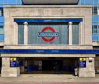
Morden is a London Underground station in Morden in the London Borough of Merton. The station is the southern terminus for the Northern line and is the most southerly station on the Underground network, despite being on the Northern Line. The next station towards north is South Wimbledon. The station is located on London Road (A24), and is in Travelcard Zone 4. Nearby are Morden Hall Park and Morden Park.

Tooting Broadway is a London Underground station in Tooting in the London Borough of Wandsworth, South London. The station is on the Northern line, between Tooting Bec and Colliers Wood stations and is in Travelcard Zone 3.
RITES Ltd, formerly known as Rail India Technical and Economic Service Limited, is a Navaratna central public sector undertaking under India's Ministry of Railways. It was incorporated on April 26, 1974, and is a multidisciplinary engineering and consultancy organization providing a comprehensive range of services from concept to commissioning in all facets of transport infrastructure and related technologies.

The Avondale–Southdown Line is a proposed railway line between Avondale and Southdown in Auckland, New Zealand. One of its main functions would be to remove north–south freight trains from parts of the Auckland rail system that have significant passenger traffic.

High Speed 2 (HS2) is a planned high-speed railway line and network of passenger train services in Great Britain. The new railway line, which is currently under construction in England, is to run between the West Midlands and London, with a spur to Birmingham. A network of train services will use the new line and existing conventional track to reach their destinations in the Midlands, North West England, and Scotland. HS2 is to be Britain's second purpose-built high-speed line after High Speed 1, which connects London to the Channel Tunnel. The majority of the project is planned to be completed between 2029 and 2033.
The Bog Walk to Port Antonio railway was a railway in Jamaica built to serve the banana, cacao, citrus and coconut districts of St Catherine, St Mary and Portland.
The Kingston to Montego Bay railway was the main railway in Jamaica, which from 1845 to 1992 linked the capital Kingston with the second city Montego Bay, passing en route most of the major towns.
The Linstead to New Works railway was a railway in Jamaica constructed in 1921 to serve a citrus growing region to the north east of Linstead.
The Spanish Town to Ewarton railway was a railway in Jamaica, built to serve the citrus growing regions in the interior of Saint Catherine, particularly those around the towns of Bog Walk, Linstead and Ewarton. It operated from 1885 to 1992.

Spanish Town railway station opened in 1845 and closed in 1992 when all passenger services in Jamaica abruptly ceased. It provided rail services to Kingston and Montego Bay, Port Antonio, Ewarton and New Works. It was 11.75 miles (18.91 km) from the Kingston terminus. It is on the list of designated National Heritage Sites in Jamaica.
Ewarton is a town in the parish of Saint Catherine, Jamaica.
References
- 1 2 3 4 5 6 7 8 9 "Table 5.6 List of JRC Railway Tunnels by Line" (PDF). Jamaica Ministry of Transport and Works, Annual Transport Statistics Report: Jamaica in Figures 2005-2006. Government of Jamaica. Archived from the original (PDF) on 11 October 2012. Retrieved 19 December 2012.
- 1 2 3 Wikimapia
- 1 2 3 UK Directorate of Overseas Surveys 1:50,000 map of Jamaica sheet various sheets and dates (1958-1973)