List of regions of Peru by population

Last updated

The following is a list of the regions of Peru ordered by population from Census 2007 and estimated population of INEI. [1]

Contents

List of Regions of Peru by population
RankImageCoat of armsRegionCapital
city
Population
Census 2007
Population
estimated 2017
[1]
1 Square in Lima Peru 01.jpg
Lima
Coat of arms of Lima.svg Lima Lima 8.445.20011.209.103
2 Piura Plaza de Armas.jpg
Piura
EscudoGanadorRegionPiura2022.svg Piura Piura 1.676.3002.753.890
3 PedestrianStreet2.jpg
Trujillo
View of Paseo Pizarro
Escudo de La Libertad Peru.svg La Libertad Trujillo 1.617.1002.201.112
4 Iglesia Santa Catalina, Cajamarca.jpg
Cajamarca cathedral
Escudo de Cajamarca.svg Cajamarca Cajamarca 1.455.2012.100.090
5 02. Islas flotantes de Uros (101).JPG
Floating islands
Escudo Departamento Puno.svg Puno Puno 1.268.4001.690.783
6 Catedral huancayo.jpg
Cathedral of Huancayo
Escudo de Junin Departamento.svg Junin Huancayo 1.225.5001.512.111
7 Machu Picchu early morning.JPG
Huayna Picchu overlooking Machu Picchu
Cusco Emblem.svg Cusco Cusco 1.171.4001.488.112
8 Aerial View, Arequipa, La Marina.jpg
Arequipa
Escudo de Armas de Arequipa.svg Arequipa Arequipa 1.152.3001.480.009
9 Chiclayo-Peru7.jpg
Chiclayo
Escudo Departamento de Lambayeque.svg [[Lambayeque Region|Lambayeque]]Chiclayo 1.112.9001.250.349
10 Satellite photo of Chimbote Peru.jpg
Chimbote
Coat of Armsof Ancash Department, Peru.svg Ancash Huaraz 1.063.5001.142.409
11 Iquitos-2012-plaza.jpg
Iquitos main square
Escudo departamento de loreto.svg Loreto Iquitos 891.7001.028.968
12 AeropuertoJorgeChavez2006-1.jpg
Airport Jorge Chavez
in Callao
Escudo del Callao.svg Callao Callao 730.8711.010.982
13 Plaza de Huanuco con la Iglesia de San Sebastian al fondo.jpg
Huánuco
Escudo De Huanuco.svg Huánuco Huánuco 762.200854.234
14 Plaza de Armas de Moyobamba de noche.jpg
Moyobamba
Escudo Region San Martin.svg San Martín Moyobamba 728.800829.520
15 Plaza armas ica noche.jpg
Ica
Escudo departamento de ica.svg Ica Ica 711.900779.372
16 Ayacucho church by night.jpg
Ayacucho
Escudo de Ayacucho.svg Ayacucho Ayacucho 612.500681.149
17 Panoramica de Huancavelica.jpg
Huancavelica
Escudo de Huancavelica.svg Huancavelica Huancavelica 454.800491.278
18 Pucallpa Plaza San Martin Fountain by Night.jpg
Pucallpa
Escudo Region Ucayali.svg Ucayali Pucallpa 432.200489.664
19 Plaza de Armas de Abancay.JPG
Abancay
Escudo Region Apurimac.svg Apurimac Abancay 404.200456.652
20 Chachapoyas air.jpg
Chachapoyas
Escudo amazonasregion.svg Amazonas Chachapoyas 376.000421.122
21 Tacna Plaza de Armas.jpg
Tacna
Escudo de San Pedro de Tacna.svg Tacna Tacna 288.800337.583
22 Mina fondo.jpg
Cerro de Pasco
Escudo regional Pasco.svg Pasco Cerro de Pasco 280.400301.988
23 Catedraltumbes.JPG
Tumbes cathedral
Escudo Region Tumbes.svg Tumbes Tumbes 200.300234.638
24 View of Moquegua Peru 2005.jpg
Moquegua
Escudo de Moquegua.svg Moquegua Moquegua 161.500178.612
25 PuertoMaldonado Plaza de Armas.jpg
Puerto Maldonado
COA Madre de Dios.svg Madre de Dios Puerto Maldonado 109.600134.105
Sources:
Censo 2007 (INEI) [2]
Estimated Population 2014 [1]

Demographic Map

Demographic Map of Peru by regions Peru - Population by region or department (2007).svg
Demographic Map of Peru by regions

See also

Related Research Articles

<span class="mw-page-title-main">Demographics of Peru</span> Demographics of country

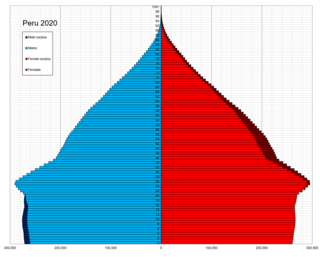
This is a demography of the population of Peru including population density, ethnicity, education level, the health of the populace, economic status, religious affiliations and other aspects of the population.

<span class="mw-page-title-main">Department of Huánuco</span> Departments of Peru

Huánuco is a department and region in central Peru. It is bordered by the La Libertad, San Martín, Loreto and Ucayali regions in the north, the Ucayali Region in the east, the Pasco Region in the south and the Lima and Ancash regions in the west. Its capital is the city Huánuco.

<span class="mw-page-title-main">Department of Junín</span> Departments of Peru

Junín is a department and region in the central highlands and westernmost Peruvian Amazon. Its capital is Huancayo.

<span class="mw-page-title-main">Department of Loreto</span> Departments of Peru

Loreto is Peru's northernmost department and region. Covering almost one-third of Peru's territory, Loreto is by far the nation's largest department, slightly larger than Japan; it is also one of the most sparsely populated regions due to its remote location in the Amazon Rainforest. Its capital is Iquitos.

<span class="mw-page-title-main">Arequipa Province</span> Province in Arequipa, Peru

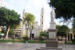
Arequipa is a province in the Arequipa Region, Peru. Its capital, Arequipa, is Peru's second most populous province of Peru. It borders the provinces of Islay, Camaná, Caylloma, and the Cusco and Puno regions. According to INEI in the year 2014 it has a population of 958.351 people.

<span class="mw-page-title-main">Districts of Peru</span> Third level administrative subdivision of Peru

The districts of Peru are the third-level country subdivisions of Peru. They are subdivisions of the provinces, which in turn are subdivisions of the larger regions or departments. There are 1,838 districts in total.

The 2005 Peru Census was a detailed enumeration of the Peruvian population. It was conducted by the Instituto Nacional de Estadística e Informática from July 18 through August 20, 2005. Its full name in Spanish is X Censo de Población y V de Vivienda. The previous census performed in Peru was the 1993 Census. The following census was the 2007 Census.

<span class="mw-page-title-main">Regions of Peru</span> First-level administrative subdivisions of Peru

According to the Organic Law of Regional Governments, the regions are, with the departments, the first-level administrative subdivisions of Peru. Since its 1821 independence, Peru had been divided into departments but faced the problem of increasing centralization of political and economic power in its capital, Lima.

Ubigeo is the coding system for geographical locations in Peru used by the National Statistics and Computing Institute to code the first-level administrative subdivision: regions, the second-level administrative subdivision: provinces and the third-level administrative subdivision: districts. There are 1874 different ubigeos in Peru.

<span class="mw-page-title-main">Sihuas Province</span> Province in Ancash, Peru

The Sihuas Province is one of twenty provinces of the Ancash Region in Peru.This province was created by Law nº 13485, dated at January 9 of 1961, when was president of Perou: Manuel Prado. It is bordered by provinces of Huaylas and Corongo on the west, Pallasca Province on the north, La Libertad Region on the east, and Pomabamba Province on the south.

<span class="mw-page-title-main">Yuracmarca District</span> District in Ancash, Peru

Yuracmarca or Yuraq Marka is one of 10 districts of the Huaylas Province in the Ancash Region of Peru. The capital of the district is the village of Yuracmarca.

<span class="mw-page-title-main">2007 Peruvian census</span>

The 2007 Peru Census was a detailed enumeration of the Peruvian population. It was conducted by the Instituto Nacional de Estadística e Informática on Sunday, October 21, 2007. Its full name in Spanish is XI Censo de Población y VI de Vivienda. The previous census performed in Peru was the 2005 Census, the following census was the 2017 Peru Census.

Zepita is one of seven districts of the Chucuito Province in Puno Region, Peru.

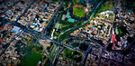
The Arequipa Metropolitan Area is the name used to refer to the metropolitan area whose principal city is Arequipa, according to Metropolitan Development Plan of Arequipa According to population statistics of INEI It is the second most populous metropolitan area of Peru in year 2017.

<span class="mw-page-title-main">Iquitos metropolitan area</span> Place in Peru

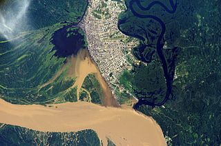
The Iquitos Metropolitan Area is the name used to refer to the Peruvian metropolitan area whose principal city is Iquitos, according to Municipality of Iquitos. According to population statistics of INEI It is the sixth most populous metropolitan area of Peru in year 2015.

<span class="mw-page-title-main">Poverty in Peru</span>

Poverty in Peru has rapidly declined since the start of the 21st century, as a result of prosperity from the international market, tourism, low inflation, greater economic opportunities, and neoliberal economic policy, at one of the fastest rates in South America. Poverty decreased from 58.7% in 2004 to 20.5% in 2018, or from 14.9 million people in poverty to fewer than 6.8 million people in 2018, with millions of Peruvians rising out of poverty according to the Instituto Nacional de Estadística e Informática (INEI). In 2019 the poverty rate decreased with another 1,7%.

References

  1. 1 2 3 INEI (ed.). "Peru: Estimated population by sex according to Departamento, province and district INEI".
  2. INEI, ed. (2008). "Censos Nacionales 2007: XI de Población y VI de Vivienda - Sistema de Consultas de Resultados Censales (INEI)". Archived from the original on September 7, 2013. Retrieved November 4, 2012.