
Mendoza, officially Province of Mendoza, is a province of Argentina, in the western central part of the country in the Cuyo region. It borders San Juan to the north, La Pampa and Neuquén to the south, San Luis to the east, and the republic of Chile to the west; the international limit is marked by the Andes mountain range. Its capital city is the homonymous city of Mendoza.

San Luis is a province of Argentina located near the geographical center of the country. Neighboring provinces are, from the north clockwise, La Rioja, Córdoba, La Pampa, Mendoza and San Juan.

San Juan Province is a province of Argentina, located in the western part of the country. Neighbouring provinces are, moving clockwise from the north, La Rioja, San Luis and Mendoza. It borders with Chile to the west.

Mendoza, officially the City of Mendoza is the capital of the province of Mendoza in Argentina. It is located in the northern-central part of the province, in a region of foothills and high plains, on the eastern side of the Andes. As of the 2010 census [INDEC], Mendoza had a population of 115,041 with a metropolitan population of 1,055,679, making Greater Mendoza the fourth largest census metropolitan area in the country.

Cuyo is the wine-producing, mountainous region of central-west Argentina. Historically it comprised the provinces of San Juan, San Luis and Mendoza. The modern New Cuyo includes both Cuyo proper and the province of La Rioja. New Cuyo is a political and economic macroregion, but culturally La Rioja is part of the North-West rather than of Cuyo.

The Salado River is a river that crosses several provinces of Argentina, flowing 1,150 kilometres (710 mi) from its source in the Salta Province to end in the Paraná River, in the Santa Fe Province. Because its origin, its flow varies widely within the year, and it can dry out in some parts of its path during the winter. The only important tributary to the river is the Horcones River, which is born in Salta as Cajón River, and joins the Salado in the Santiago del Estero Province.

The Atuel River is a river located mainly in the south of the Argentine province of Mendoza, with its last part in La Pampa. It is a tributary of the Desaguadero River.

The San Juan River is, together with the Jáchal, the most important river of the Argentine province of San Juan. Both join the Desaguadero/Colorado system that ends at the Atlantic Ocean.

The Mendoza River is a river in the province of Mendoza, Argentina. It is formed in the Andes range between the Aconcagua and the Tupungato, by the confluence of the Vacas, the Cuevas and the Tupungato rivers, the last being its major tributary.
The Tunuyán River is a river in the Argentine province of Mendoza. It is born in Mount Tupungato, in the Andes range, and flows initially to the northeast, passing by the city of Tunuyán. It is then dammed by the El Carrizal Dam, after which it turns east-southeast passing near the cities of Rivadavia, Santa Rosa and La Paz. Finally, it branches into the Tunuyán Nuevo (north) and Tunuyán Viejo (south), and empties into the Desaguadero River.

The Diamante River is a river in the Argentine province of Mendoza. It is born from glaciers on the Maipo, a volcano in the Andes range in the Argentine–Chilean border, and flows east until emptying in the Desaguadero River. Its drainage basin covers an area of 2,750 square kilometres (1,060 sq mi) in the central region of Mendoza.
The Monte Desert is a South American desert, lying entirely within Argentina and covering approximately the submontane areas of Catamarca, La Rioja, San Juan, San Luis and Mendoza Provinces, plus the western half of La Pampa Province and the extreme north of Río Negro Province. The desert lies southeast of the Atacama Desert in Chile and Peru, north of the larger Patagonian Desert, east of the Andes and west of the Sierra de Córdoba.
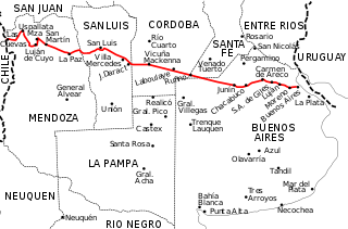
National Route 7 is a road in Argentina. It crosses the country from east to west, from the capital to the border with Chile, thus linking the Atlantic coast with the Andes, crossing the provinces of Buenos Aires, Santa Fe, Córdoba, San Luis and Mendoza. It has a total length of 1,224 km (761 mi), of which 367 km (228 mi) (30%) are freeways.

The Desaguadero River, also known as Risawariru or Uchusumain, is a river shared between Bolivia and Peru. It drains Lake Titicaca from the southern part of the river basin, flowing south and draining approximately five percent of the lake's flood waters into Lake Uru Uru and Lake Poopó. Its source in the north is very near the Peruvian border.

25 de Mayo is a department of the province of San Juan (Argentina), located southwest of the province. Be department is characterized by its high production wine and olivícola.

Mendoza Province is Argentina's most important wine region, accounting for nearly two-thirds of the country's entire wine production. Located in the eastern foothills of the Andes, in the shadow of Aconcagua, vineyards are planted at some of the highest altitudes in the world, with the average site located 600–1,100 metres (2,000–3,600 ft) above sea level. The principal wine producing areas fall into two main departments-Maipú and Luján, which includes Argentina's first delineated appellation established in 1993 in Luján de Cuyo. The pink-skinned grapes of Criolla Grande and Cereza account for more than a quarter of all plantings but Malbec is the region's most important planting, followed closely by Cabernet Sauvignon, Tempranillo and Chardonnay. Mendoza is considered the heart of the winemaking industry in Argentina with the vast majority of large wineries located in the provincial capital of Mendoza.

The Sierra de las Quijadas National Park is a national park located in the northwestern part of the Argentine province of San Luis. It was established on December 10, 1991, to protect the natural features, representative of the Semiarid Chaco and the High Monte ecoregions.

Desaguadero is a village and municipality straddling the border of Mendoza Province and San Luis Province in central Argentina.

The Argentine Monte (NT0802), or Low Monte, is an ecoregion of dry thorn scrub and grasslands in Argentina. It is one of the driest regions in the country. Human settlements are mainly near water supplies such as rivers or oases. Deforestation and over-grazing around these settlements have caused desertification.