Cuyo (Argentina)

Last updated
Location of the Cuyo region in Argentina Cuyo province in Argentina.png
Location of the Cuyo region in Argentina

Cuyo is the wine-producing, mountainous region of central-west Argentina. Historically it comprised the provinces of San Juan, San Luis and Mendoza. The modern New Cuyo includes both Cuyo proper and the province of La Rioja. New Cuyo is a political and economic macroregion, but culturally La Rioja is part of the North-West rather than of Cuyo.

Contents

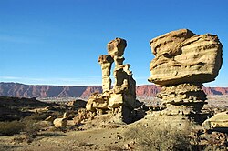
Cuyo has some of the most popular tourist attractions in Argentina and the highest mountain massifs in the Andes, including Aconcagua itself, the highest peak outside Asia, and the Ischigualasto Provincial Park.

The soil is arid and reddish, crossed by few rivers. Most of the rivers are fed by the thawing of snow on the peaks, and their volume of water increases considerably in spring. The Desaguadero River is the main collector, receiving waters from the Bermejo, Vinchina and Salado before reaching the Colorado River.

Viticulture is one of the main activities of the area. The wine production of the region represents almost 80% of national production, and the wines are highly regarded throughout the world. Olives, potatoes, tomatoes and some fruits are also cultivated, and there is production of sweets and preserved foodstuffs. Quarrying and oil exploitation are other important industries.

The cities and towns in the region are characterised by colonial low houses and churches, and narrow streets, contrasting in the principal cities with the modern parts. The Universidad Nacional de Cuyo, founded in 1939, is the most important within these provinces, and has its campus in Mendoza, but has faculties as far as Río Negro.

Cuyo province by GDP (nominal) and GDP per capita

This article includes a list of Cuyo Province sorted by their Gross Domestic Product (nominal) per capita , the value of all final goods and services produced within a nation in a given year, divided by the average population for the same year. The table below includes data for the year 2013 for the 23 provinces

RankProvinceGDPComparable
country
($)
per capita
Comparable
country
1Mendoza22,023Zambia11,957Libya
2 San Juan 7,341Niger10,170Costa Rica
3San Luis6,117Guinea13,201Poland
4La Rioja (Argentina)2,447Maldives6,844China

Table of Cuyo provinces according to the 2001 census [INDEC].

ProvincePopulation% of CuyoArea (km2)% of CuyoDensity (inhabitants/km2)
Mendoza 1,579,65155.28148,82736.7610.6
San Juan 620,02321.7089,65122.146.9
San Luis 367,93312.8876,74818.954.8
La Rioja 289,98310.1589,68022.153.2
Cuyo Total2,857,590100404,9061007.1
Argentina Total36,260,130-2,780,4031-13.0

Climate

Colder weather predominates at higher elevations which can receive snow during the winter Tormenta de nieve en Cacheuta.jpg
Colder weather predominates at higher elevations which can receive snow during the winter
Much of the region is dry, depending on rivers for irrigation Rio San Juan en la Quebrada de Ullum.jpg
Much of the region is dry, depending on rivers for irrigation

The region of Cuyo has an arid climate or a semi-arid climate with an average annual precipitation of about 100 to 500 millimetres (4 to 20 in) that is generally unreliable from year to year. [1] [2] The region, which encompasses a wide range of latitudes combined with elevations ranging from 500 m to nearly 7,000 m means that it has a diverse range of different climates. [2] [3] In general, most of the region has a temperate climate with higher elevation valleys having a more milder climate. [4] At the highest elevations (over 4,000 m), icy conditions persist year round. [2] The diurnal range is very large with very hot temperatures during the day followed by cold nights. [5] Amongst all locations in Argentina, the region has the largest diurnal range in the country with areas in San Juan Province having a diurnal range exceeding 19.1 °C (34.38 °F). [6] The Andes prevent rain–bearing clouds from the Pacific Ocean from coming in, while its latitude puts it in a band of the sub-tropical high pressure belt keeping this region dry. [1] [7] With very low humidity, abundant sunshine throughout the year, and a temperate climate, the region is suitable for wine production. [3] Droughts are often frequent and prolonged. [7] The Cuyo region is influenced by the subtropical, semi–permanent South Atlantic anticyclone to the east in the Atlantic, the semi-permanent South Pacific anticyclone to the west of the Andes, the development of a low pressure system ("Chaco low") over northern Argentina and westerlies in the southern parts of the region. [1] [8] Most of the precipitation falls during the summer, when hot temperatures and high insolation lead to the development of a low pressure system ("Chaco low") situated over northern Argentina that interacts with the South Atlantic anticyclone to generate a pressure gradient that brings moist easterly winds to the region, favouring precipitation, which mostly occurs in the form of convective thunderstorms. [7] [9] [1] [8] More than 85% of the annual rainfall occurs from October to March, which represents the warm season. [1] In contrast, the winter months are dry due to these systems weakening, and the lower insolation that weakens the Chaco low over northern Argentina. [8] Eastern and southeastern areas of the region receive more precipitation than the western areas since they receive more summer rainfall. [8] As such, most of Mendoza province and San Juan province receive the lowest annual precipitation with mean summer precipitation averaging less than 100 mm (3.9 in) and in rare cases, no summer rainfall. [8] Further eastwards in San Luis province, mean summer rainfall averages around 500 mm (20 in) and can exceed 700 mm (28 in) in some areas. [8] [10] Higher elevation locations receive precipitation in the form of snow during the winter months. [11] [12] [13] In the Cuyo region, annual precipitation is highly variable from year to year and appears to follow a cycle between dry and wet years in periods of about 2, 4–5, 6–8, and 16–22 years. [1] In wet years, easterly winds caused by the subtropical South Atlantic anticyclone are stronger, which causes more moisture towards this region while during the dry years, these winds are weaker. [1] [8]

Summers in the region are hot and generally very sunny, averaging as much as 10 hours per day. [5] [14] In contrast, winters are dry and cold and average around 7–8 hours of sunshine per day. [5] [14] Since this region has a wide range of elevations, ranging from 500 m to nearly 7,000 m, temperatures can vary widely with elevation. In the lowlands of Mendoza province, which lie at an elevation of around 440 m to 530 m, mean annual temperatures range from 18.2 to 18.7 °C (64.8 to 65.7 °F) in the northern parts to 15 °C (59 °F) in the south. [15] At higher elevation locations and in the western parts of Mendoza province, the mean annual temperatures range from −1.7 °C (28.9 °F) in Cristo Redentor to 13.6 °C (56.5 °F) with a larger difference in temperatures between winter and summer months. [11] In San Juan Province, the mean annual temperature ranges from 17.3 °C (63.1 °F) in the provincial capital to −0.2 °C (31.6 °F). [16] In San Luis province, mean annual temperatures range from 15.8 °C (60.4 °F) in Villa Reynolds to 16.6 °C (61.9 °F) in the provincial capital. [10] [17] The Sierras Pampeanas, which cross into both San Juan province and San Luis province have a milder climate with mean annual temperatures ranging from 12 to 18 °C (53.6 to 64.4 °F). [13] In all locations, at elevations over 3,800 m, permafrost is present while icy conditions persist year round at elevations over 4,000 m. [2]

The Zonda, a Foehn wind characterized by warm, dry air can cause temperatures to exceed 30 °C (86.0 °F) in some cases while in summer, temperatures can exceed 45 °C (113.0 °F) such as in 2003. [18] [19] This wind often precedes following a cold front passage across Argentina and tends to occur when a low pressure system brings heavy rain to the Chilean side, and when an upper level trough allows the winds to pass over the Andes to descend downwards. [18] [20] [21] As such, when a zonda wind event occurs, the temperature may raise as much as 20 °C (68.0 °F) in a few hours with humidity approaching 0%. [20] In contrast, cold waves are also common, owing to the Andes channeling cold air from the south, allowing cold fronts to frequently come during the winter months, causing cool to cold temperatures with temperatures that can fall below freezing. [21] [22] Temperatures can dip below −10 to −30 °C (14.0 to −22.0 °F) at the higher elevations. [12]

Tourism

As in other parts of Argentina, nature tourism is an important source of income. Amongst sites that receive a large number of visitors, the following are its main attractions:

Related Research Articles

<span class="mw-page-title-main">Mendoza Province</span> Province of Argentina

Mendoza, officially Province of Mendoza, is a province of Argentina, in the western central part of the country in the Cuyo region. It borders San Juan to the north, La Pampa and Neuquén to the south, San Luis to the east, and the republic of Chile to the west; the international limit is marked by the Andes mountain range. Its capital city is the homonymous city of Mendoza.

<span class="mw-page-title-main">Río Negro Province</span> Province of Argentina

Río Negro is a province of Argentina, located in northern Patagonia. Neighboring provinces are from the south clockwise Chubut, Neuquén, Mendoza, La Pampa and Buenos Aires. To the east lies the Atlantic Ocean.

Zonda wind is a regional term for the foehn wind that often occurs on the eastern slope of the Andes, in Argentina.

<span class="mw-page-title-main">Chubut Province</span> Province of southern Argentina

Chubut is a province in southern Argentina, situated between the 42nd parallel south, the 46th parallel south, the Andes range to the west, and the Atlantic ocean to the east. The province's name derives from the Tehuelche word chupat, meaning "transparent," their description of the Chubut River.

<span class="mw-page-title-main">Catamarca Province</span> Province of Argentina

Catamarca is a province of Argentina, located in the northwest of the country. The province had a population of 334,568 as per the 2001 census [INDEC], and covers an area of 102,602 km2. Its literacy rate is 95.5%. Neighbouring provinces are : Salta, Tucumán, Santiago del Estero, Córdoba, and La Rioja. To the west it borders the country of Chile.

<span class="mw-page-title-main">Salta Province</span> Province of Argentina

Salta is a province of Argentina, located in the northwest of the country. Neighboring provinces are from the east clockwise Formosa, Chaco, Santiago del Estero, Tucumán and Catamarca. It also surrounds Jujuy. To the north it borders Bolivia and Paraguay and to the west lies Chile.

<span class="mw-page-title-main">Santa Cruz Province, Argentina</span> Province of Argentina

Santa Cruz Province is a province of Argentina, located in the southern part of the country, in Patagonia. It borders Chubut Province to the north, and Chile to the west and south, with an Atlantic coast on its east. Santa Cruz is the second-largest province of the country, and the least densely populated in mainland Argentina.

<span class="mw-page-title-main">Neuquén Province</span> Province of Argentina

Neuquén is a province of Argentina, located in the west of the country, at the northern end of Patagonia. It borders Mendoza Province to the north, Rio Negro Province to the southeast, and Chile to the west. It also meets La Pampa Province at its northeast corner.

<span class="mw-page-title-main">La Pampa Province</span> Province of Argentina

La Pampa is a sparsely populated province of Argentina, located in the Pampas in the center of the country. Neighboring provinces are from the north clockwise San Luis, Córdoba, Buenos Aires, Río Negro, Neuquén and Mendoza.

<span class="mw-page-title-main">San Juan Province, Argentina</span> Province of Argentina

San Juan Province is a province of Argentina, located in the western part of the country. Neighbouring provinces are, moving clockwise from the north, La Rioja, San Luis and Mendoza. It borders with Chile to the west.

<span class="mw-page-title-main">Mendoza, Argentina</span> City in Mendoza, Argentina

Mendoza, officially the City of Mendoza is the capital of the province of Mendoza in Argentina. It is located in the northern-central part of the province, in a region of foothills and high plains, on the eastern side of the Andes. As of the 2010 census [INDEC], Mendoza had a population of 115,041 with a metropolitan population of 1,055,679, making Greater Mendoza the fourth largest census metropolitan area in the country.

<span class="mw-page-title-main">Trevelin</span> Town in Chubut, Argentina

Trevelin is a town in the western part of the Patagonian Argentine province of Chubut. The town lies on the eastern banks of the Percy River. It is located in the department of Futaleufú, 22 kilometres (14 mi) south of Esquel, and had 6,395 inhabitants at the time of the 2001 census [INDEC] and 7,908 inhabitants in the 2010 census [INDEC].

<span class="mw-page-title-main">San Luis, Argentina</span> City in San Luis, Argentina

San Luis is the capital city of San Luis Province in the Cuyo region of Argentina. It is also the seat of the Juan Martín de Pueyrredón Department.

<span class="mw-page-title-main">Mesopotamia, Argentina</span> Region in Argentina

La Mesopotamia or Región Mesopotámica is the humid and verdant area of northeast Argentina, comprising the provinces of Misiones, Entre Ríos, and Corrientes. The landscape and its characteristics are dominated by two rivers: the Paraná and the Uruguay.

<span class="mw-page-title-main">Argentine Northwest</span>

The Argentine Northwest is a geographic and historical region of Argentina composed of the provinces of Catamarca, Jujuy, La Rioja, Salta, Santiago del Estero and Tucumán.

<span class="mw-page-title-main">Argentine wine</span> Fifth largest producer of wine in the world

Argentina is the fifth largest producer of wine in the world. Argentine wine, as with some aspects of Argentine cuisine, has its roots in Spain. During the Spanish colonization of the Americas, vine cuttings were brought to Santiago del Estero in 1557, and the cultivation of the grape and wine production stretched first to neighboring regions, and then to other parts of the country.

<span class="mw-page-title-main">Climate of Chile</span> Overview of the climate of Chile

The climate of Chile comprises a wide range of weather conditions across a large geographic scale, extending across 38 degrees in latitude, making generalizations difficult. According to the Köppen system, Chile within its borders hosts at least seven major climatic subtypes, ranging from low desert in the north, to alpine tundra and glaciers in the east and southeast, tropical rainforest in Easter Island, Oceanic in the south and Mediterranean climate in central Chile. There are four seasons in most of the country: summer, autumn, winter, and spring.

<span class="mw-page-title-main">Climate of Argentina</span> Overview of the climate of Argentina

The climate of Argentina varies from region to region, as the vast size of the country and wide variation in altitude make for a wide range of climate types. Summers are the warmest and wettest season in most of Argentina except in most of Patagonia where it is the driest season. Warm in the north, cool in the center and cold in the southern parts experiencing frequent frost and snow. Because southern parts of the country are moderated by the surrounding oceans, the cold is less intense and prolonged than areas at similar latitudes in the northern hemisphere. Spring and autumn are transition seasons that generally feature mild weather.

<span class="mw-page-title-main">Mendoza wine</span> Wine-producing region in Argentina

Mendoza Province is Argentina's most important wine region, accounting for nearly two-thirds of the country's entire wine production. Located in the eastern foothills of the Andes, in the shadow of Aconcagua, vineyards are planted at some of the highest altitudes in the world, with the average site located 600–1,100 metres (2,000–3,600 ft) above sea level. The principal wine producing areas fall into two main departments-Maipú and Luján, which includes Argentina's first delineated appellation established in 1993 in Luján de Cuyo. The pink-skinned grapes of Criolla Grande and Cereza account for more than a quarter of all plantings but Malbec is the region's most important planting, followed closely by Cabernet Sauvignon, Tempranillo and Chardonnay. Mendoza is considered the heart of the winemaking industry in Argentina with the vast majority of large wineries located in the provincial capital of Mendoza.

<span class="mw-page-title-main">Climatic regions of Argentina</span> Overview of climatic regions of Argentina

Due to its vast size and range of altitudes, Argentina possesses a wide variety of climatic regions, ranging from the hot subtropical region in the north to the cold subantarctic in the far south. Lying between those is the Pampas region, featuring a mild and humid climate. Many regions have different, often contrasting, microclimates. In general, Argentina has four main climate types: warm, moderate, arid, and cold in which the relief features, and the latitudinal extent of the country, determine the different varieties within the main climate types.

References

  1. 1 2 3 4 5 6 7 Eduardo, Agosta; Compagnucci, Rosa (2012). "Central-West Argentina Summer Precipitation Variability and Atmospheric Teleconnections" (PDF). Journal of Climate. 25 (5): 1657–1677. Bibcode:2012JCli...25.1657A. doi:10.1175/JCLI-D-11-00206.1. hdl: 11336/68178 .
  2. 1 2 3 4 Daudon, Dominique; Moreiras, Stella; Beck, Elise (2014). "Multi Hazard Scenarios in the Mendoza/San Juan Provinces, Cuyo Region Argentina". Procedia Economics and Finance. 18: 560–567. doi: 10.1016/S2212-5671(14)00976-9 .
  3. 1 2 "Reseña de la vitivinicultura argentina" (in Spanish). Acenología. Retrieved 11 June 2015.
  4. Canziani, Pablo; Scarel, Eduardo. "South American Viticulture, Wine Production, and Climate Change" (PDF). Pontificia Universidad Católica Argentina. Retrieved 18 June 2015.
  5. 1 2 3 "Región de Cuyo" (PDF) (in Spanish). Ministerio del Interior y Transporte. Retrieved June 17, 2015.
  6. "Datos extremos en el país y en el mundo" (in Spanish). Servicio Meteorológico Nacional. Retrieved June 19, 2015.
  7. 1 2 3 "Climate Overview" (PDF). Met Office. Retrieved 7 June 2015.
  8. 1 2 3 4 5 6 7 Compagnucci, Rosa; Eduardo, Agosta; Vargas, W. (2002). "Climatic change and quasi-oscillations in central-west Argentina summer precipitation: main features and coherent behaviour with southern African region" (PDF). Climate Dynamics. 18 (5): 421–435. Bibcode:2002ClDy...18..421C. doi:10.1007/s003820100183. S2CID   128568839. Archived from the original (PDF) on 23 June 2015. Retrieved 17 June 2015.
  9. Veblen, Thomas; Young, Kenneth; Orme, Antony (2007). The Physical Geography of South America. Oxford University Press. p. 233. ISBN   978-0-19-531341-3.
  10. 1 2 "Provincia de San Luis–Clima Y Metéorologia" (in Spanish). Secretaria de Mineria de la Nacion (Argentina). Archived from the original on July 1, 2015. Retrieved June 22, 2015.
  11. 1 2 "Provincia de Mendoza–Clima Y Metéorologia" (in Spanish). Secretaria de Mineria de la Nacion (Argentina). Archived from the original on June 23, 2015. Retrieved June 22, 2015.
  12. 1 2 "Provincia de San Juan–Clima Y Metéorologia" (in Spanish). Secretaria de Mineria de la Nacion (Argentina). Archived from the original on June 23, 2015. Retrieved June 22, 2015.
  13. 1 2 "Región de Las Sierras Pampeanas" (PDF) (in Spanish). Retrieved June 23, 2015.
  14. 1 2 "Argentina". BBC Weather. Retrieved 7 June 2015.
  15. Loyarte, Maria; Menenti, Massimo; Diblasi, Angela (2008). "Modelling bioclimate by means of Fourier analysis of NOAA–AVHRR NDVI time series in Western Argentina". International Journal of Climatology. 28 (9): 1175–1188. Bibcode:2008IJCli..28.1175L. doi:10.1002/joc.1610. S2CID   129352110.
  16. "Cap. 10 Clima de la Provincia de San Juan" (in Spanish). Centro Regional de Investigaciones Científicas y Tecnológicas. Retrieved June 22, 2015.
  17. "Villa Reynolds Climate Normals 1961–1990". National Oceanic and Atmospheric Administration . Retrieved June 22, 2015.
  18. 1 2 Norte, Federico; Ulke, Ana (2008). "The severe zonda wind event of 11 July 2006 east of the Andes Cordillera (Argentine): a case study using the BRAMS model" (PDF). Climate Dynamics. 18 (5): 421–435. Bibcode:2002ClDy...18..421C. doi:10.1007/s003820100183. S2CID   128568839 . Retrieved 23 June 2015.
  19. Seluchi, Marcelo; Norte, Federico; Gomes, Jorge; Simonelli, Silvia (2008). Synoptic and Thermodynamic Analysis of an Extreme Heat Wave over Subtropical South America (PDF). 8th International Conference on Southern Hemisphere Meteorology and Oceanography. Archived from the original (PDF) on 24 June 2015. Retrieved 23 June 2015.
  20. 1 2 Seluchi, Marcelo; Norte, Federico; Satyamurty, Prakki; Chou, Sin (2003). "Analysis of Three Situations of the Foehn Effect over the Andes (Zonda Wind) using the Eta–CPTEC Regional Model". Weather and Forecasting. 18 (3): 481–501. Bibcode:2003WtFor..18..481S. doi:10.1175/1520-0434(2003)18<481:AOTSOT>2.0.CO;2. hdl: 11336/40961 .
  21. 1 2 Nobre, Carlos; Chou, S.; Figueroa, S.; Nicolini, Matillde (1998). "The Andes & Associated Circulations over Central & Eastern South America" (PDF). Retrieved 23 June 2015.
  22. Seluchi, Marcelo; Garreaud, Rene; Norte, Federico; Saulo, A. (2006). "Influence of the Subtropical Andes on Baroclinic Disturbances: A Cold Front Case Study" (PDF). Monthly Weather Review. 134 (11): 3317–3335. Bibcode:2006MWRv..134.3317S. doi:10.1175/MWR3247.1. Archived from the original (PDF) on 24 June 2015. Retrieved 23 June 2015.

Coordinates: 32°54′26″S68°03′37″W / 32.9073°S 68.0603°W / -32.9073; -68.0603