
Major rivers of South Sumatra province on Sumatra island
List of rivers flowing in the province of South Sumatra, Indonesia: [1] [2]
List of rivers flowing in the province of South Sumatra, Indonesia: [1] [2]

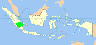
South Sumatra is a province of Indonesia, located in the southeast of the island of Sumatra. The capital and largest city of the province is the city of Palembang. The province borders the provinces of Jambi to the north, Bengkulu to the west and Lampung to the south, as well a maritime border with the Bangka Belitung Islands to the east. It is the largest province in the island of Sumatra, and it is slightly smaller than Portugal. The Bangka Strait in the east separates South Sumatra and the island of Bangka, which is part of the Bangka Belitung Islands province. The province has an area of 91,592.43 km2 (35,364 sq mi) and had a population of 8,467,432 at the 2020 Census; the official estimate as at mid-2022 was 8,657,008. The province is rich in natural resources, such as petroleum, natural gas and coal. The province is inhabited by many different ethnic groups, with Palembangese being largest ethnic group. Most speak the Palembang language, which is mutually intelligible to both Indonesian and local Palembang Malay. Other ethnic groups include the Javanese, Sundanese, Minangkabau and Chinese. Most are concentrated in urban areas and are largely immigrants from other parts of Indonesia.

The Musi River is a river in Southern Sumatra, Indonesia. It flows from south-west to north-east, from the Barisan Mountains range that form the backbone of Sumatra, in Kepahiang Regency, Bengkulu Province, to the Bangka Strait that forms an extension of the South China Sea. The Musi is about 750 kilometers long, and drains most of South Sumatra province. After flowing through Palembang, the provincial capital, it joins with several other rivers, including the Banyuasin River, to form a delta near the town of Sungsang. The river, dredged to a depth of about 6.5 meters, is navigable by large ships as far as Palembang, which is the site of major port facilities used primarily for the export of petroleum, rubber and palm oil.

Musi Banyuasin Regency is a regency of South Sumatra province, in Indonesia. Originally much larger, it was reduced by about 45% of its former area on 10 April 2002 by the splitting off of most of its eastern and northeastern districts to form the new Banyuasin Regency. It now has a total area of 14,265.96 km2 (5,508 sq mi) and a population of 561,458 at the 2010 Census and 622,206 at the 2020 Census; the official estimate as at mid 2022 was 633,124.
The Komering River is a river in South Sumatra, Indonesia. It is a tributary of the Musi River.
The Ogan River is a river in South Sumatra, Indonesia. It is a tributary of the Musi River in Southern Sumatra. Flowing entirely in the South Sumatra province, it rises in Barisan Mountains and meanders slowly eastwards to join the Musi at Kertapati, Palembang. The Ogan ranks as the third longest river in South Sumatra. The river either borders or flows through the regencies of South OKU, OKU, OKI, and Ogan Ilir.

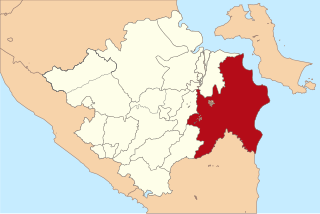
Banyuasin is a regency of South Sumatra Province in Indonesia. The Regency was formed on 10 April 2002 from the coastal and eastern areas formerly part of the Musi Banyuasin Regency. It takes its name from the main river which drains that area, the Banyuasin River. Pangkalan Balai is the regency seat. The regency borders Musi Banyuasin Regency, Jambi province and Bangka Strait to the north, Bangka Strait to the east, Ogan Komering Ilir Regency, Muara Enim Regency, and the city of Palembang to the south, and Musi Banyuasin Regency to the west. It has an area of 11,832.99 km2 and had a population of 749,107 at the 2010 census and 836,914 at the 2020 census; the official estimate as at mid 2022 was 839,401. Much of the regency is coastal lowland.
Ogan Komering Ilir Regency is a regency of South Sumatra Province, Indonesia. It takes its name from the Ogan River and the Komering River, which are the two main rivers that drain the area. The name Ilir means downstream. The administrative centre is the town of Kayu Agung. The regency borders Banyuasin Regency to the northwest, Bangka Strait, and the Java Sea to the east, Lampung Province to the south, and Palembang city, Ogan Ilir Regency, and East Ogan Komering Ulu Regency to the west.
The 2018 South Sumatra gubernatorial election took place on 27 June 2018 as part of the simultaneous local elections. It was held to elect the governor of South Sumatra along with their deputy, whilst members of the provincial council will be re-elected in 2019.
The Simpang-kanan River is a river in southern Sumatra, Indonesia, about 600 km northwest of the capital Jakarta. It is a tributary of the Rawas River.