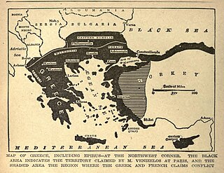
List of settlements in the Evros regional unit

Last updated

This is a list of settlements in the Evros regional unit , Greece:

Evros (regional unit) Regional unit in East Macedonia and Thrace, Greece

Evros is one of the regional units of Greece. It is part of the region of East Macedonia and Thrace. Its name is derived from the river Evros, which appears to have been a Thracian hydronym. Evros is the northernmost regional unit. It borders Turkey to the east, across the river Evros, and it borders Bulgaria to the north and the northwest. Its capital is Alexandroupoli. Together with the regional units Rhodope and Xanthi, it forms the geographical region of Western Thrace.

Greece republic in Southeast Europe

Greece, officially the Hellenic Republic, also known as Hellas, is a country located in Southern and Southeast Europe, with a population of approximately 11 million as of 2016. Athens is the nation's capital and largest city, followed by Thessaloniki.

Contents

Aisymi Place in Greece

Aisymi is a village in the southern part of the Evros regional unit, Greece. It is located on the Greek National Road 53, about 20 km north of the city of Alexandroupoli. In 2011 its population was 193 for the village and 253 for the community, including the village Leptokarya.

Alexandroupoli Place in Greece

Alexandroupoli or Alexandroupolis is a city in Greece and the capital of the Evros regional unit in East Macedonia and Thrace. It is an important port and commercial center of northeastern Greece.

Amorio, Evros Place in Greece

Amorio is a village in the municipal unit of Orfeas, northeastern Evros, Greece. It is situated at 2 km from the right bank of the river Evros, that forms the border with Turkey here. Amorio is 6 km northeast of Lavara, 7 km southwest of Didymoteicho and 21 km west of Uzunköprü (Turkey). The Greek National Road 51/E85 and the railway from Alexandroupoli to Didymoteicho pass through the village.

By municipality

Samothrace (no subdivisions)

Abandoned villages

Agrafiotika, Aliki, Amfithea, Amygdalia, Apidochori, Archondiko, Asia, Chaldini, Chandakas, Chloi, Daskaleio, Delitio, Drepano, Drymos, Dymi, Fere Kalyva, Gavria, Iana, Katsika, Kissos, Kitrinopetra, Kliso, Ktima, Mavropetra, Megali Kavissos, Melopetra, Mikraki, Nea Vrysi, Nefeli, Ourania, Palaistra, Patara, Pessani, Polyvlasto, Potamos, Profitis Ilias, Pyrolithos, Samaras, Sanidochori, Sarpidonia, Spano, Tarsio, Theiafi, Treis Myloi, Triada, Tsaliki, Vafeio, Vergi, Vyrini, Xirodendro, Yalia.

See also

Related Research Articles

Megali Idea irredentist nationalist movement aiming to establish a Greek state that would encompass all historically ethnic Greek-inhabited areas, including Greeks under Ottoman rule and regions inhabited by ancient Greeks (Balkans, Anatolia, Cyprus)

The Megali Idea was an irredentist concept of Greek nationalism that expressed the goal of establishing a Greek state that would encompass all historically ethnic Greek-inhabited areas, including the large Greek populations that were still under Ottoman rule after the end of the Greek War of Independence (1821–1828) and all the regions that traditionally belonged to Greeks in ancient times.

Eastern Macedonia and Thrace Administrative region of Greece in Macedonia and Thrace

Eastern Macedonia and Thrace is one of the thirteen administrative regions of Greece. It consists of the northeastern parts of the country, comprising the eastern part of the region of Greek Macedonia along with the region of Western Thrace, and the islands of Thasos and Samothrace.

Nea Ionia Place in Greece

Nea Ionia is a northern suburb of Athens, Greece, and a municipality of the Attica region. It was named after Ionia, the region in Anatolia from which many Greeks migrated in the 1920s as a part of the Population exchange between Greece and Turkey.

Nea Smyrni Place in Greece

Nea Smyrni is a municipality and a southern suburb of Athens, Greece. At the 2011 census, it had 73,076 inhabitants. It was named after the city Smyrna, from where a large number of refugees arrived and settled in the Nea Smyrni area following the 1922 population exchange between Greece and Turkey.

Orestiada Place in Greece

Orestiada, is the northeasternmost and northernmost city of Greece and the second largest town of the Evros regional unit of Thrace. The population is around 20,000.

Tigani (Τηγάνι) is a small peninsula in the landscape of Mani in southern Greece. The name is Greek for "frying pan". Tigani is surrounded by the sea except for a narrow strip of land that connects to the mainland. The ruins of a probable medieval castle can be found there. Its position and its walls made it extremely hard to capture.

Kerasea or Kerasia may refer to several villages in Greece:

Feres, Evros Place in Greece

Feres is a town and a former municipality in the Evros regional unit, East Macedonia and Thrace, Greece. Since the 2011 local government reform it is part of the municipality Alexandroupoli, of which it is a municipal unit. The municipal unit has an area of 411.160 km2. Population 8,551 (2011). Feres is linked with the GR-2 or the Egnatia Odos and the GR-51 (Alexandroupoli - Orestiada - Ormenio. The Evros river along with Turkey is to the east and also includes the entire delta to the south.

Avia, Messenia Place in Greece

Avia is a village and a former municipality in Messenia, Peloponnese, Greece. Since the 2011 local government reform it is part of the municipality West Mani, of which it is a municipal unit. The municipal unit has an area of 179.828 km2. In 2011 its population was 281 for the village, 611 for the community and 2,246 for the municipal unit. The seat of the municipality was in Kampos. Avia is a popular tourist destination. It also has a large olive production. Avia is situated on the east coast of the Messenian Gulf, southeast of Kalamata, southwest of Sparta and northwest of Kardamyli.
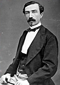
Panagia, Chalkidiki Place in Greece

Panagia is a former municipality in Chalkidiki, Greece. Since the 2011 local government reform it is part of the municipality Aristotelis, of which it is a municipal unit. The 2011 census recorded 3,526 inhabitants in the municipal unit. The municipal unit of Panagia covers an area of 204.903 km2.

Kavyli Place in Greece

Kavyli is a village in the northern part of the Evros regional unit in Greece. It is part of the municipal unit of Vyssa, which is part of the municipality Orestiada since 2011. In 2011 its population was 758. It is bypassed by the Greek National Road 51. It is 7 km north of the centre of Orestiada, and 4 km southwest of Nea Vyssa.

Megali Doxipara Place in Greece

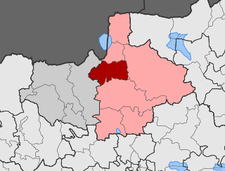
Megali Doxipara is a village in the municipality of Orestiada in the northern part of the Evros regional unit in Greece. Megali Doxipara is located about 23 km west of the centre of Orestiada. The nearest villages are Doxa to the south, Chandras to the east and Zoni to the west.

Megali Mantineia Place in Greece

Megali Mantineia is a mountain settlement in the municipal unit of Avia, Messenia, Greece. In 2011, it had a population of 191. It sits at 200 m above sea level, 2 km southeast of Avia, 3 km south of Mikri Mantineia and 10 km southeast of Kalamata. Many of its residents only stay there during the summer months.

Mikri Mantineia Place in Greece

Mikri Mantineia is a seaside village in the municipality of Kalamata, Messenia, Greece. In 2011, it had a population of 705. It is situated at 20 m above sea level, on the northeastern shore of the Gulf of Messenia. Its main industry is tourism. Mikri Mantineia is 2 km northeast of Avia, 3 km north of Megali Mantineia and 6 km southeast of Kalamata.