Amorio is a village in the municipal unit of Orfeas, northeastern Evros, Greece. It is situated at 2 km from the right bank of the river Evros, that forms the border with Turkey here. Amorio is 6 km northeast of Lavara, 7 km southwest of Didymoteicho and 21 km west of Uzunköprü (Turkey). The Greek National Road 51/E85 and the railway from Alexandroupoli to Didymoteicho pass through the village.
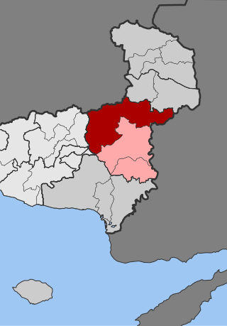
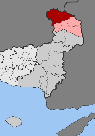
Orfeas, named after the mythical musician Orpheus, is a former municipality in the Evros regional unit, East Macedonia and Thrace, Greece. Since the 2011 local government reform it is part of the municipality Soufli, of which it is a municipal unit. Its land area is 643.266 km2 (248.366 sq mi). It is located in the north-central part of Evros, and borders both southeastern Bulgaria and northwestern Turkey. The seat of the municipality was in Lavara. Much of the land is mountainous and forested to the west, extending up to the Rhodope regional unit. It is linked with GR-51. The town of Lávara sits on a plain. It is located SE of Svilengrad, S of Edirne, Turkey and Orestiada, and 13 km N of Soufli and 78 km N of Alexandroupoli. The municipality's next largest towns are Agriani, Mega Dereio and Amorio.
Trígono is a former municipality in the Evros regional unit, East Macedonia and Thrace, Greece. Since the 2011 local government reform, it is part of the municipality Orestiada, of which it is a municipal unit. The municipal unit has an area of 392.538 km2. The seat of the municipality was in Dikaia. The municipality was created in 1997 under the Capodistrian Plan. Trigono is the country's northernmost municipal unit, situated in the triangle between the rivers Evros and Ardas. It borders Bulgaria to the north and west, and Turkey to the northeast. The nearest cities are Svilengrad (Bulgaria) to the north, Edirne (Turkey) to the east, and Orestiada to the southeast. The area consists mainly of low hills, with plains in the river valleys, and higher elevations up to 400 m towards the west.

Tycheró is a town and a former municipality in the Evros regional unit, East Macedonia and Thrace, Greece. Since the 2011 local government reform it is part of the municipality Soufli, of which it is a municipal unit. The municipal unit has an area of 220.411 km2. Tychero is situated near the river Evros, which forms the border with Turkey here.
Aisymi is a village in the southern part of the Evros regional unit, Greece. It is located next to the Greek National Road 53, about 20 km north of the city of Alexandroupoli. In 2021 the population was 220 for the community, including the village Leptokarya.
Arzos is a village in the northern part of the Evros regional unit in Greece. It is situated on the left bank of the river Ardas, about 20 km northwest of Orestiada. Arzos is part of the municipal unit of Trigono. In 2021 its population was 259 for the municipal community, which includes the village Kanadas.
Komara is a village in the northwestern part of the Evros regional unit in northern Greece. Komara is in the municipal unit of Trigono. Komara is situated on the left (northern) bank of the river Arda, near the border with Bulgaria. It is 2 km north of Kyprinos, the nearest larger village. It is 20 km south of the Bulgarian town Svilengrad, 27 km northwest of Orestiada and 29 km west of the Turkish city Edirne.
Plati is a village in the northern part of the Evros regional unit in Greece. It is part of the municipal unit Trigono. Plati is located on the left bank of the river Ardas, between the villages Elaia to the west and Arzos to the east.
Marasia is a village in the northern part of the Evros regional unit in Greece. Marasia is part of the municipal unit of Trigono. It is situated between the rivers Evros and Ardas, close to their confluence. The Evros forms the border with Turkey here, and the Turkish city Edirne is 7 km to its east. Marasia is bypassed by the Greek National Road 51/E85.
Spilaio is a village in the northern part of the Evros regional unit in Greece. It is in the municipal unit of Trigono. It is in a relatively flat, agricultural area. The nearest larger villages are Dikaia to its north, and Plati to its southeast.
Elaia is a village in the northern part of the Evros regional unit, Greece. Elaia is in the municipal unit of Trigono. The village is located on the left bank of the river Arda. The nearest villages are Plati to its northeast and Fylakio to its south.

Milia is a village in the northern part of the Evros regional unit, Greece. It is in the municipal unit of Trigono. It is on the left bank of the river Arda, and on the border with Bulgaria. The nearest larger places are Kyprinos to its east, and Ivaylovgrad (Bulgaria) to its southwest.
Fylakio is a village in the Evros regional unit of northeast Greece. Fylakio is in the municipal unit of Kyprinos. In 2021 the population was 867 for the community, including the villages Ammovouno and Keramos. It is located on the right bank of the river Ardas, about halfway between Ivaylovgrad (Bulgaria) and Edirne (Turkey).
Zoni is a village in the northern part of the Evros regional unit in Greece. Zoni is in the municipal unit of Kyprinos. In 2021 its population was 294 for the municipal community, including the villages Chelidona and Mikra Doxipara. It is located close to the border with Bulgaria, south of Kyprinos village, and east of Ivaylovgrad, Bulgaria. Zoni is on the Greek National Road 53.
Avas or Avantas is a village in the southern part of the Evros regional unit, Greece. Avantas is located 10 km north of Alexandroupoli. It is on the Greek National Road 53, between Alexandroupoli to the south and Aisymi to the north. In 2021 its population was 486.

Protokklisi is a village and a community in the central part of the Evros regional unit in Greece. Protoklissi is in the municipal unit of Orfeas. In 2021 its population was 776 for the community, including the village Agriani. Protokklisi is located about 15 km northwest of Soufli, in the valley of a right tributary of the river Evros.
Mega Dereio is a village in the central part of the Evros regional unit in Greece. It is part of the municipal unit of Orfeas within the municipality of Soufli. Together with 6 other villages, it forms the community of Mikro Dereio. It is situated near the upper course of the river Erythropotamos, in the Eastern Rhodope Mountains. The Greek National Road 53 passes through the village.
Mikro Dereio is a village and a community in the central part of the Evros regional unit in Greece. It is situated on the left bank of the river Erythropotamos, in the Eastern Rhodope Mountains. The border with Bulgaria is 5 km to the north. Mikro Dereio is on the Greek National Road 53. In 2021 its population was 1,836 for the community, which consists of the villages Mikro Dereio, Geriko, Goniko, Mega Dereio, Petrolofos, Roussa and Sidirochori. It is the most populous community of the municipal unit of Orfeas.
Kavyli is a village in the northern part of the Evros regional unit in Greece. It is part of the municipal unit of Vyssa, which is part of the municipality Orestiada since 2011. It is bypassed by the Greek National Road 51. It is 7 km north of the centre of Orestiada, and 4 km southwest of Nea Vyssa.
Rizia is a village in the municipal unit of Vyssa in the northern part of the Evros regional unit in Greece. It is situated on the right bank of the river Ardas. The nearest large village is Kastanies to its northeast, on the Turkish border.
