The name Tina has been used for five tropical cyclones worldwide:
The name Lee has been used for seven tropical cyclones worldwide. In the Atlantic, it replaced the name Lenny.

The 2012 Pacific typhoon season was a slightly above average but destructive season, though rather active since 2004. It produced 25 named storms, fourteen typhoons, and four intense typhoons. It was an event in the annual cycle of tropical cyclone formation, in which tropical cyclones form in the western Pacific Ocean. The season ran throughout 2012, though most tropical cyclones typically develop between May and October. The season's first named storm, Pakhar, developed on March 28, while the season's last named storm, Wukong, dissipated on December 29. The season's first typhoon, Guchol, reached typhoon status on June 15, and became the first super typhoon of the year on June 17.

The 2017 Pacific typhoon season was a below-average season in terms of accumulated cyclone energy and the number of typhoons and super typhoons, and the first since the 1977 season to not produce a Category 5-equivalent typhoon on the Saffir–Simpson scale. The season produced a total of 27 named storms, 11 typhoons, and only two super typhoons, making it an average season in terms of storm numbers. It was an event in the annual cycle of tropical cyclone formation, in which tropical cyclones form in the western Pacific Ocean. The season runs throughout 2017, though most tropical cyclones typically develop between May and October. The season's first named storm, Muifa, developed on April 25, while the season's last named storm, Tembin, dissipated on December 26. This season also featured the latest occurrence of the first typhoon of the year since 1998, with Noru reaching this intensity on July 23.
This timeline documents all of the events of the 2012 Pacific typhoon season, the period that tropical cyclones formed in the Western Pacific Ocean during 2012. Most of these tropical cyclones formed between May and November 2012. The scope of this article is limited to the Pacific Ocean, north of the equator between 100°E and the International Date Line. Tropical storms that form in the entire Western Pacific basin are assigned a name by the Japan Meteorological Agency (JMA). Tropical depressions that form in this basin are given a number with a "W" suffix by the United States' Joint Typhoon Warning Center (JTWC). In addition, the Philippine Atmospheric, Geophysical and Astronomical Services Administration (PAGASA) assigns names to tropical cyclones that enter or form in the Philippine area of responsibility. These names, however, are not in common use outside of the Philippines.
The name Pamela has been used for eleven tropical cyclones worldwide, one in the Eastern Pacific Ocean and ten in the Western Pacific.
Severe Tropical Storm Pakhar, known in the Philippines as Tropical Storm Jolina, was a strong tropical storm that impacted South China during late August 2017. This storm followed Typhoon Hato which affected the area a few days prior. Pakhar was the fourteenth named storm of the Pacific typhoon season. Pakhar developed from a tropical depression to the east of Luzon during August 24, and intensified into a tropical storm later that day. Pakhar made landfall over in Aurora on August 25. Pakhar gradually intensified and peaked as a severe tropical storm by August 27, making landfall over Taishan, Jiangmen in Southern China.

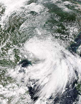
Tropical Storm Pakhar was a strong tropical storm that affected the Philippines and the Indochina as a whole in early-April 2012. The fourth tropical depression and the first named storm of the annual typhoon season, Pakhar's origins can be traced from a disturbance that persisted to the northwest of Palau. Located in an overall unfavorable environment, the disturbance crossed the Philippine archipelago before subsequently developed into a tropical depression on March 26. Now under favorable conditions, the depression intensified to a tropical storm, receiving the name Pakhar from the JMA. On the other hand, the JTWC upgraded it to a Category 1 typhoon due to an eye feature; however, this was short-lived as the agency downgraded back Pakhar to a tropical storm due to the system entering colder sea surface temperatures. On April 2, the system made landfall near Vũng Tàu, Vietnam and it dissipated thereafter. Its remnants also affected Cambodia, Laos and Thailand.
This page is based on this
Wikipedia article Text is available under the
CC BY-SA 4.0 license; additional terms may apply.
Images, videos and audio are available under their respective licenses.