
A geologic map or geological map is a special-purpose map made to show various geological features. Rock units or geologic strata are shown by color or symbols. Bedding planes and structural features such as faults, folds, are shown with strike and dip or trend and plunge symbols which give three-dimensional orientations features.
A stratigraphic unit is a volume of rock of identifiable origin and relative age range that is defined by the distinctive and dominant, easily mapped and recognizable petrographic, lithologic or paleontologic features (facies) that characterize it.
The Devonian Mahantango Formation is a mapped bedrock unit in Pennsylvania, West Virginia, and Maryland. It is named for the North branch of the Mahantango Creek in Perry and Juniata counties in Pennsylvania. It is a member of the Hamilton Group, along with the underlying the Marcellus Formation Shale. South of Tuscarora Mountain in south central Pennsylvania, the lower members of this unit were also mapped as the Montebello Formation. Details of the type section and of stratigraphic nomenclature for this unit as used by the U.S. Geological Survey are available on-line at the National Geologic Map Database.

In geology, a group is a lithostratigraphic unit consisting of a series of related formations that have been classified together to form a group. Formations are the fundamental unit of stratigraphy. Groups may sometimes be combined into supergroups.
The Lias Group or Lias is a lithostratigraphic unit found in a large area of western Europe, including the British Isles, the North Sea, the Low Countries and the north of Germany. It consists of marine limestones, shales, marls and clays.
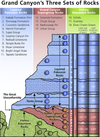
A stratigraphic column is a representation used in geology and its subfield of stratigraphy to describe the vertical location of rock units in a particular area. A typical stratigraphic column shows a sequence of sedimentary rocks, with the oldest rocks on the bottom and the youngest on top.

The Mancos Shale or Mancos Group is a Late Cretaceous geologic formation of the Western United States.
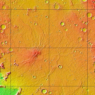
The Hesperian is a geologic system and time period on the planet Mars characterized by widespread volcanic activity and catastrophic flooding that carved immense outflow channels across the surface. The Hesperian is an intermediate and transitional period of Martian history. During the Hesperian, Mars changed from the wetter and perhaps warmer world of the Noachian to the dry, cold, and dusty planet seen today. The absolute age of the Hesperian Period is uncertain. The beginning of the period followed the end of the Late Heavy Bombardment and probably corresponds to the start of the lunar Late Imbrian period, around 3700 million years ago (Mya). The end of the Hesperian Period is much more uncertain and could range anywhere from 3200 to 2000 Mya, with 3000 Mya being frequently cited. The Hesperian Period is roughly coincident with the Earth's early Archean Eon.
The Oriskany Sandstone is a Middle Devonian age unit of sedimentary rock found in eastern North America. The type locality of the unit is located at Oriskany Falls in New York. The Oriskany Sandstone extends throughout much of the Appalachian Basin.

The Salem Formation is a geologic formation in Illinois, Indiana, Kentucky, and Missouri. It preserves fossils dating back to the Mississippian subperiod.

The Chattanooga Shale is a geologic formation in Alabama, Arkansas, Kentucky, Missouri and Tennessee. It preserves conodont fossils dating to the Devonian Period. It occurs mostly as a subsurface geologic formation composed of layers of shale. It is located in Eastern Tennessee and also extends into southeastern Kentucky, northeastern Georgia, and northern Alabama. This part of Alabama is part of the Black Warrior Basin.
The Davis Formation is a geologic formation in Indiana and Missouri. It preserves fossils dating back to the Cambrian period.
The Keokuk Limestone is a geologic formation in Illinois, Iowa and Missouri. It preserves fossils dating back to the Mississippian sub-period.

The Warsaw Formation is a geologic formation in Illinois, Iowa and Missouri. It preserves fossils dating back to the Mississippian subperiod.

The Kimmswick Limestone is an Ordovician geologic formation in Arkansas, Illinois and Missouri. Fossils occurring in the Kimmswick include corals, bryozoans, brachiopods, conodonts, trilobites, crinoids and mollusks.
The Bonneterre Formation is an Upper Cambrian geologic formation which outcrops in the St. Francois Mountains of the Missouri Ozarks. The Bonneterre is a major host rock for the lead ores of the Missouri Lead Belt.

The Fort Hays Limestone is a member of the Niobrara Formation of the Colorado Group exposed in Colorado, Kansas, Nebraska, and South Dakota and is named for the bluffs near the old Fort Hays, a well-known landmark in western Kansas.


