
Surveying or land surveying is the technique, profession, art, and science of determining the terrestrial two-dimensional or three-dimensional positions of points and the distances and angles between them. A land surveying professional is called a land surveyor. These points are usually on the surface of the Earth, and they are often used to establish maps and boundaries for ownership, locations, such as the designed positions of structural components for construction or the surface location of subsurface features, or other purposes required by government or civil law, such as property sales.

A theodolite is a precision optical instrument for measuring angles between designated visible points in the horizontal and vertical planes. The traditional use has been for land surveying, but it is also used extensively for building and infrastructure construction, and some specialized applications such as meteorology and rocket launching.

An alidade or a turning board is a device that allows one to sight a distant object and use the line of sight to perform a task. This task can be, for example, to triangulate a scale map on site using a plane table drawing of intersecting lines in the direction of the object from two or more points or to measure the angle and horizontal distance to the object from some reference point's polar measurement. Angles measured can be horizontal, vertical or in any chosen plane.

A total station (TS) or total station theodolite (TST) is an electronic/optical instrument used for surveying and building construction. It is an electronic transit theodolite integrated with electronic distance measurement (EDM) to measure both vertical and horizontal angles and the slope distance from the instrument to a particular point, and an on-board computer to collect data and perform triangulation calculations.
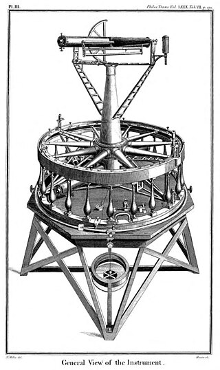
The Ramsden surveying instruments are those constructed by Jesse Ramsden and used in high precision geodetic surveys carried out in the period 1784 to 1853. This includes the five great theodolites—great in name, great in size and great in accuracy—used in surveys of Britain and other parts of the world. Ramsden also provided the equipment used in the measurement of the many base lines of these surveys and also the zenith telescope used in latitude determinations.

Gunter's chain is a distance measuring device used for surveying. It was designed and introduced in 1620 by English clergyman and mathematician Edmund Gunter (1581–1626). It enabled plots of land to be accurately surveyed and plotted, for legal and commercial purposes.

The Great Trigonometrical Survey was a project that aimed to survey the entire Indian subcontinent with scientific precision. It was begun in 1802 by the British infantry officer William Lambton, under the auspices of the East India Company. Under the leadership of his successor, George Everest, the project was made the responsibility of the Survey of India. Everest was succeeded by Andrew Scott Waugh, and after 1861, the project was led by James Walker, who oversaw its completion in 1871.

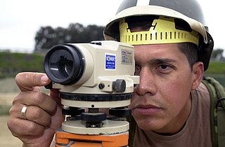
A level is an optical instrument used to establish or verify points in the same horizontal plane in a process known as levelling. It is used in conjunction with a levelling staff to establish the relative height or levels of objects or marks. It is widely used in surveying and construction to measure height differences and to transfer, measure, and set heights of known objects or marks.

Stadiametric rangefinding, or the stadia method, is a technique of measuring distances with a telescopic instrument. The term stadia comes from a Greek unit of length Stadion which was the typical length of a sports stadium of the time. Stadiametric rangefinding is used for surveying and in the telescopic sights of firearms, artillery pieces, or tank guns, as well as some binoculars and other optics. It is still widely used in long-range military sniping, but in many professional applications it is being replaced with microwave, infrared, or laser rangefinding methods. Although much easier to use, electronic rangefinders can give away the shooter's position to a well-equipped adversary, and the need for accurate range estimation existed for much longer than electronic rangefinders small and rugged enough to be suitable for military use.

A dioptra is a classical astronomical and surveying instrument, dating from the 3rd century BC. The dioptra was a sighting tube or, alternatively, a rod with a sight at both ends, attached to a stand. If fitted with protractors, it could be used to measure angles.

Tacheometry is a system of rapid surveying, by which the horizontal and vertical positions of points on the earth's surface relative to one another are determined without using a chain or tape, or a separate levelling instrument. Instead of the pole normally employed to mark a point, a staff similar to a level staff is used. This is marked with heights from the base or foot, and is graduated according to the form of tacheometer in use.

A bull's eye level is a type of spirit level that allows for the leveling of planes in two dimensions — both the 'pitch' and 'roll' in nautical terms. Standard tubular levels only consider one dimension. Bull's eye levels are used primarily by carpenters in construction, but can also be found as features of compasses or other devices that need to be kept from tipping in certain directions. Small bull's eye levels are also found incorporated into tripods.
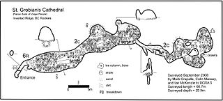
A cave survey is a map of all or part of a cave system, which may be produced to meet differing standards of accuracy depending on the cave conditions and equipment available underground. Cave surveying and cartography, i.e. the creation of an accurate, detailed map, is one of the most common technical activities undertaken within a cave and is a fundamental part of speleology. Surveys can be used to compare caves to each other by length, depth and volume, may reveal clues on speleogenesis, provide a spatial reference for other areas of scientific study and assist visitors with route-finding.

A circumferentor, or surveyor's compass, is an instrument used in surveying to measure horizontal angles. It was superseded by the theodolite in the early 19th century.
A plane table is a device used in surveying site mapping, exploration mapping, coastal navigation mapping, and related disciplines to provide a solid and level surface on which to make field drawings, charts and maps. The early use of the name plain table reflected its simplicity and plainness rather than its flatness. "Plane" refers to the table being both flat and levelled (horizontal).
Sokkia Co., Ltd. was founded in 1920 as Sokkisha in Japan. It makes measurement instruments for the surveying, construction and industrial measurement industries. In 2008 Sokkia was acquired by Topcon, but still maintains a separate brand.
Position resection and intersection are methods for determining an unknown geographic position by measuring angles with respect to known positions. In resection, the one point with unknown coordinates is occupied and sightings are taken to the known points; in intersection, the two points with known coordinates are occupied and sightings are taken to the unknown point.
John Hood (1720–c.1783) was an Irish surveyor and inventor, born in Moyle, County Donegal.
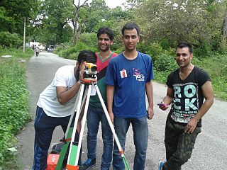
Survey Camp is an army tradition that was discontinued in the later part of twentieth century but was reinstated in 2002 across the universities of the world with a whole new structure. It is the civil engineering training course for two weeks usually after completion four semesters of bachelor of technology that consists of 8 days working in the field and 6 days of map preparation in the computer lab. Experts say that survey camp provides necessary foundation for civil engineers. Each day in the course there are at least 8 hours of working in the field. Students are divided into groups and they get out with practising surveyors and use their equipment out in the field. A camp incharge teacher appoints group leaders for each group; the leaders are responsible for all the works of his particular group and the equipment. In the computer lab, students learn applications such as AutoCAD and Carlson Survey. The students use these programs to take data collected from the field to develop topographic maps of the particular area. The basic aim of the survey camp is to know various works carried out in the industrial field by surveying, which includes determining the topography of particular area with the help of survey work, map study and reconnaissance work. The methods used for surveying are traversing, levelling and contouring

Burt's solar compass or astronomical compass/sun compass is a surveying instrument that makes use of the Sun's direction instead of magnetism. William Austin Burt invented his solar compass in 1835. The solar compass works on the principle that the direction to the Sun at a specified time can be calculated if the position of the observer on the surface of the Earth is known, to a similar precision. The direction can be described in terms of the angle of the Sun relative to the axis of rotation of the planet.