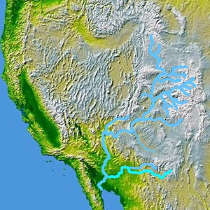
The map highlights the Gila River extending eastward across southern Arizona to the southwestern corner of Arizona and its input into the Colorado River, from its origins about 400 miles east in the southwestern corner of the state of New Mexico. The highlighted river north and adjacent is the Salt River which has the Verde River connected just prior to its drainage into the Gila River. The Verde and Salt rivers effectively drain the western and central portion of the Mogollon Rim, NW to SE across the state, and the White Mountain region of the Mogollon Rim, in east-central, and east Arizona.
The Verde River drainage into the Salt River, at its very northwestern drainages, east of Kingman, Arizona, even drains the South Rim, of the Grand Canyon. Thus, the Gila River watershed, may cover more than sixty (60) percent of the state.
Three north–south drainages and Salt–Verde watershed
From west to east, the Hassayampa River's final destination is the dry desert, and groundwater. The second drainage, the Agua Fria River enters the Gila in western Phoenix, but not as a flowing river. The Agua Fria puts most of its winter drainage, or snowmelt/rain floodwaters into Lake Pleasant Regional Park. The largest of the three north/south rivers, the Verde River (plus the East Verde), goes through Horseshoe Reservoir and Bartlett Reservoir before joining the Salt River. (The Salt River enters the Gila, 40 miles downstream, through central Phoenix, and five miles before the Agua Fria River tributary. The Hassayampa River is 35 miles farther downstream, and just prior to the tributary of Centennial Wash.)
The Verde River drainage extends north and northwest of the Agua Fria River, and Hassayampa River drainages, and continues to the South Rim of the Grand Canyon. The combined Salt River–Verde River drainage would be the major (and central) component of the south Mogollon Rim drainages of central Arizona (the Mogollon Plateau also drains north to the Little Colorado River).
The Gila River, a tributary of the Colorado along the width of southern Arizona, and its valley can be traced on a map of Arizona. The Gila forms the boundary between various counties in Eastern Arizona.
The Gila River is a 649-mile (1,044 km)-long tributary of the Colorado River flowing through New Mexico and Arizona in the United States. The river drains an arid watershed of nearly 60,000 square miles (160,000 km2) that lies mainly within the U.S., but also extends into northern Sonora, Mexico.
The Salt River is a river in Gila and Maricopa counties in Arizona, United States, that is the largest tributary of the Gila River. The river is about 200 miles (320 km) long. Its drainage basin is about 13,700 square miles (35,000 km2) large. The longest of the Salt River's many tributaries is the 195-mile (314 km) Verde River. The Salt's headwaters tributaries, the Black River and East Fork, increase the river's total length to about 300 miles (480 km). The name Salt River comes from the fact that the river flows over large salt deposits shortly after the merging of the White and Black Rivers.
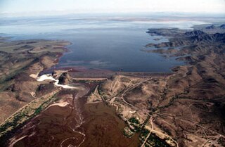
The Painted Rock Dam is an earthfill embankment dam located west of Gila Bend, Arizona. It is primarily used for flood control purposes.
The Agua Fria River is a 120-mile (190 km) long intermittent stream which flows generally south from 20 miles (32 km) east-northeast of Prescott in the U.S. state of Arizona. Prescott draws much of its municipal water supply from the upper Agua Fria watershed. The Agua Fria runs through the Agua Fria National Monument. The river then flows through a small canyon called "Black Canyon" into Lake Pleasant, a popular recreation area near Peoria, Arizona. (There is a large "Black Canyon" on the Colorado River along the Arizona–Nevada border.)
The Yavapai are a Native American tribe in Arizona. Historically, the Yavapai – literally “people of the sun” – were divided into four geographical bands who identified as separate, independent peoples: the Ɖo:lkabaya, or Western Yavapai; the Yavbe', or Northwestern Yavapai; the Guwevkabaya, or Southeastern Yavapai; and the Wi:pukba, or Northeastern Yavapai – Verde Valley Yavapai.
The Gila chub is a species of ray-finned fish in the family Cyprinidae. It is found in Mexico and the United States. The Gila chub is closely related to the roundtail chub. This species is commonly found in association with the Gila topminnow, the desert and Sonora sucker, and the longfin and speckled dace.
The San Cristobal Wash is an ephemeral wash and watercourse of the San Cristobal Valley, flowing north into the Gila River Valley of the southwestern desert region of Arizona. Besides Death Valley, the Chihuahuan Desert area, and regions of Baja Peninsula North America, the southeast California deserts along the Lower Colorado River Valley, this drainage region is in the harshest desert regions of North America.
Bouse Wash is one of the larger eastern-bank dry washes that enter the Colorado River in the Lower Colorado River Valley. It is located in La Paz County, extreme western Arizona.
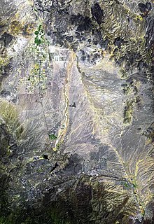
Centennial Wash is an ephemeral dry wash that forms the final watershed of the Gila River in central Arizona – before the river turns south. From the Centennial Wash confluence, the Gila turns south, then southwest to exit Arizona on the California border adjacent Yuma.
The Growler Mountains is a 23-mile, (37-km) long north-south trending mountain range of far western Pima County, Arizona that lies 12 miles (19 km) west of Ajo, Arizona. This desert region of southern Arizona lies in the north and central Sonoran Desert, and is one of the drier desert areas of North America.
Tenmile Wash is an ephemeral wash and watercourse about 85 miles (137 km) long in the northern Sonoran Desert of south-central Arizona. It forms the eastern drainage of a two drainage system of dry washes into the Gila River Valley; both flow northwesterly, and the western drainage is the San Cristobal Wash Drainage of approximately the same length.
The East Verde River is a tributary of the Verde River in the U.S. state of Arizona. Beginning on the Mogollon Rim near Washington Park, it flows generally southwest through Gila County and the Tonto National Forest northeast of Phoenix. Near the middle of its course, it passes to within about 5 miles (8 km) of Payson, which is southeast of the river. The East Verde River flows through parts of the Mazatzal Wilderness west of Payson.
The Sacramento Wash is a major drainage of northwest Arizona in Mohave County. The wash is east of the Black Canyon of the Colorado and drains into the south-flowing Colorado River 45 mi south of Lake Mohave, and 90 mi south of Hoover Dam at Lake Mead. The wash outfall is in the center-south of the Havasu-Mohave Lakes Watershed. An equivalent wash drains to the west of the Colorado River and the Black Canyon, draining southeast Nevada and a small part of California, the Piute Wash of the Piute Valley. The Piute Wash outfall is upstream of the Sacramento's outfall by about 15 miles.
The Tonto Basin, also known as Pleasant Valley, covers the main drainage basin of Tonto Creek and its tributaries in central Arizona, at the southwest of the Mogollon Rim, the higher elevation transition zone across central and eastern Arizona. Although the word tonto means silly or foolish in Spanish, this place name is derived from the Apache word, Koun’nde, which means wild, rough people and refers to the indigenous Dilzhe’e Tonto Apache.
Lonesome Valley is a 23-mile (37 km) long valley located in central-north Yavapai County, Arizona; the valley is an extension southeastwards from Chino Valley (Arizona), the location of the Big Chino Wash, which becomes the Verde River at Paulden, Arizona; Paulden is located at the northwest terminus of Lonesome Valley. A small sub-valley is located on the northeast perimeter of Chino Valley, Arizona, located in the center-northwest of Lonesome Valley. The valley is named Little Chino Valley, and is the small valley link between Chino Valley, northwest, and Lonesome Valley, southeast.
The Tonopah Desert is a small desert plains region of the Sonoran Desert, located west of Phoenix, Arizona. It is adjacent north of Interstate 10 and lies at the southwest intersection of the Hassayampa River with the Gila River. The Tonopah Desert is also just north of the Gila Bend Mountains massif which create the Gila Bend of the river.
The Peacock Mountains are a small, 26 mi (42 km) long mountain range in northwest Arizona, US. The range is a narrow sub-range, and an extension north, at the northeast of the Hualapai Mountains massif, which lies to the southwest. The range is defined by the Hualapai Valley to the northwest, and north and south-flowing washes on its east border, associated with faults and cliffs; the Cottonwood Cliffs are due east, and are connected to the Aquarius Cliffs southward at the west perimeter of the Aquarius Mountains; the cliffs are a result of the Aquarius Fault, which is an extension southward from the Grand Wash Cliffs and Grand Wash Fault which crosses the Colorado River at Lake Mead, and the west perimeter of the Grand Canyon/Colorado Plateau.
Granite Creek is a 38-mile (61 km) tributary of the Verde River in the U.S. state of Arizona. It flows generally north-northeast from the Bradshaw Mountains of west-central Arizona through the city of Prescott and the Granite Dells to meet the river at the north end of the Little Chino Valley east of Sullivan Lake.
This page is based on this Wikipedia article Text is available under the CC BY-SA 4.0 license; additional terms may apply. Images, videos and audio are available under their respective licenses.