The United States National Geodetic Survey lists thirteen craters in the state of Alaska .

The United States National Geodetic Survey lists thirteen craters in the state of Alaska .


Crater Lake is a volcanic crater lake in south-central Oregon in the Western United States. It is the main feature of Crater Lake National Park and is famous for its deep blue color and water clarity. The lake partly fills a 2,148-foot-deep (655 m) caldera that was formed around 7,700 years ago by the collapse of the volcano Mount Mazama. No rivers flow into or out of the lake; the evaporation is compensated for by rain and snowfall at a rate such that the total amount of water is replaced every 250 years. With a depth of 1,949 feet (594 m), the lake is the deepest in the United States. In the world, it ranks tenth for maximum depth, as well as third for mean (average) depth.

Mount Erebus is the second-highest volcano in Antarctica, the highest active volcano in Antarctica, and the southernmost active volcano on Earth. It is the sixth-highest highest point of an island, and the second most prominent mountain in Antarctica after Mount Vinson. It has a summit elevation of 3,794 metres (12,448 ft). It is located in the Ross Dependency on Ross Island, which is also home to three inactive volcanoes: Mount Terror, Mount Bird, and Mount Terra Nova. The mountain was named by Captain James Clark Ross in 1841 for his ship, the Erebus.

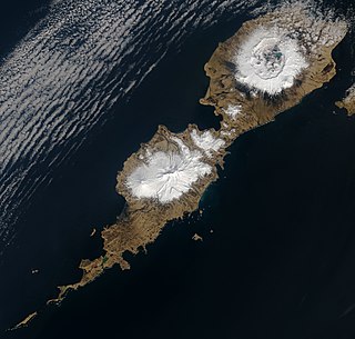
Unimak Island is the largest island in the Aleutian Islands chain of the U.S. state of Alaska.

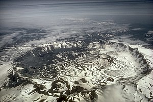
Aniakchak National Monument and Preserve is a U.S. National Monument and National Preserve, consisting of the region around the Aniakchak volcano on the Aleutian Range of south-western Alaska. It has erupted at least 40 times over the last 10,000 years. The 601,294-acre (243,335 ha) monument is one of the least-visited places in the National Park System due to its remote location and difficult weather. The area was proclaimed a National Monument on December 1, 1978, and established as a National Monument and Preserve on December 2, 1980. The National Monument encompasses 137,176 acres (55,513 ha) and the preserve 464,118 acres (187,822 ha). Visitation to Aniakchak is the lowest of all areas of the U.S. National Park System, according to the NPS, with only 100 documented recreational visits in 2017. Most visitors fly into Surprise Lake inside Aniakchak Crater, but the frequent fog and other adverse weather conditions make landing in the lake difficult. It is also possible to fly into the nearby village of Port Heiden and proceed overland to the Aniakchak Crater.

Umnak is one of the Fox Islands of the Aleutian Islands. With 686.01 square miles (1,776.76 km2) of land area, it is the third largest island in the Aleutian archipelago and the 19th largest island in the United States. The island is home to a large volcanic caldera on Mount Okmok and the only field of geysers in Alaska. It is separated from Unalaska Island by Umnak Pass. In 2000, Umnak was permanently inhabited by only 39 people and by 2010, around 18, placing the settlement of Nikolski in difficulty and its school was closed.

Mount Emmons is a post-caldera stratovolcano within the Emmons Lake caldera on the Alaska Peninsula within the Lake and Peninsula Borough, Alaska, United States.

Mount Vsevidof is a stratovolcano in the U.S. state of Alaska. Its summit is the highest point on Umnak Island, one of the eastern Aleutian Islands. Its symmetrical cone rises abruptly from its surroundings. The base of the volcano is around 10 km (6 mi) wide, steepening from about 15 degrees at 300 m (980 ft) altitude to around 30 degrees near the summit. Some glacial tongues have cut through narrow canyons up to 120 m (390 ft) deep, due to ice filling the crater and extending down the north and east flanks of the cone. Vsevidof's most recent eruption was caused by an earthquake on March 9, 1957. The eruption began March 11, and ended the next day.

Little Sitkin Island is a volcanic island in the Rat Islands archipelago of the Western Aleutian Islands, Alaska, about 3 miles (4.8 km) east of Davidof Island. Great Sitkin Island lies 185 miles (298 km) further east in the Andreanof Islands.

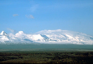
Mount Wrangell, in Ahtna K’ełt’aeni or K’ełedi when erupting, is a massive shield volcano located in Wrangell-St. Elias National Park and Preserve in southeastern Alaska, United States. The shield rises over 12,000 feet (3,700 m) above the Copper River to its southwest. Its volume is over 220 cubic miles (920 km3), making it more than twice as massive as Mount Shasta in California, the largest stratovolcano by volume in the Cascades. It is part of the Wrangell Volcanic Field, which extends for more than 250 kilometers (160 mi) across Southcentral Alaska into the Yukon Territory in Canada, and has an eruptive history spanning the time from Pleistocene to Holocene.

The Alaska Volcano Observatory (AVO) is a joint program of the United States Geological Survey (USGS), the Geophysical Institute of the University of Alaska Fairbanks (UAFGI), and the State of Alaska Division of Geological and Geophysical Surveys (ADGGS). AVO was formed in 1988, and uses federal, state, and university resources to monitor and study Alaska's volcanology, hazardous volcanoes, to predict and record eruptive activity, and to mitigate volcanic hazards to life and property. The Observatory website allows users to monitor active volcanoes, with seismographs and webcameras that update regularly. AVO now monitors more than 20 volcanoes in Cook Inlet, which is close to Alaskan population centers, and the Aleutian Arc due to the hazard that plumes of ash pose to aviation.
Zubof Rock is a small island near Sitka, Alaska, United States, off the northeast coast of Baranof Island. Located in an area of Kelp Bay known as The Basin, it was entered into the United States Geological Survey's Geographic Names Information System on March 31, 1981. Its name dates back to 1895 as Zuboff, which was a Russian surname, as reported by Lieutenant Commander J. F. Moser of the United States Navy.
Aaron Island is an island in the City and Borough of Juneau, Alaska, United States. It was named by Lester A. Beardslee in 1880. Located in Lynn Canal, it is 1.2 miles (1.9 km) northwest of Point Stephens and 17 miles (27 km) northwest of the city of Juneau.

Table Top Mountain is a mountain in the city and borough of Juneau, Alaska, United States. It is a peak of the Boundary Ranges, located on Douglas Island 2 miles (3.2 km) northeast of Cropley Lake and 3.5 miles (5.6 km) west of the city of Juneau.

Kowee Creek is a river on Douglas Island in the City and Borough of Juneau, Alaska, United States. Its origin is southeast of Mount Troy and it flows north-northeast to Gastineau Channel near West Juneau; it is 0.5 miles (0.80 km) southwest of the city of Juneau. Kowee Creek is nearly 10 miles (16 km) long. It has a drainage basin of about 50 square miles (130 km2) and two transverse tributaries.
Fritz Cove is a bay on the northwestern coast of Douglas Island in the City and Borough of Juneau, Alaska, United States. Lying in Stephens Passage, it is 8 miles (13 km) northwest of the city of Juneau.
Bird Island is an island in the City and Borough of Juneau, Alaska, United States. It was named by Captain Lester A. Beardslee of the United States Navy in 1880. Located off the eastern shore of Favorite Channel, it is 2.4 miles (3.9 km) northwest of Pearl Harbor and 20 miles (32 km) northwest of the city of Juneau. The name was first published by the United States Coast and Geodetic Survey in 1883.
Canyon Island is an island in the City and Borough of Juneau, Alaska, United States. Located in the Taku River, it is 2.5 miles (4.0 km) northeast of the mouth of the Wright River and 32 miles (51 km) northeast of the city of Juneau.
Coghlan Island is an island in the City and Borough of Juneau, Alaska, United States. Located in Stephens Passage, it is 1.2 miles south of Fairhaven and 11 miles northwest of the city of Juneau. It was named in 1885 by the United States Coast and Geodetic Survey for United States Navy officer Joseph Coghlan, who commanded the USS Adams during its survey of southeastern Alaska from 1883 to 1884.

Fisher Caldera, also known as Mount Fisher and Fisher Volcano, is a large volcanic caldera, measuring about 6.8 miles (11 km) by 11 miles (18 km), located on Unimak Island in the Aleutian Islands of Alaska. Formed by the destructive eruption of an andesitic stratovolcano about 9,100 years ago, it contains three crater lakes, one 2 miles (3.2 km) wide and two others about 1.5 miles (2.4 km) wide. Small peaks rising 2,000 feet (600 m) and 2,031 feet (619 m) are also present in the caldera. Fisher Caldera is located just 13 miles (21 km) from the Mount Westdahl volcano.

Eldred Rock is an island in the boroughs of Juneau and Haines, Alaska, United States. Located in Lynn Canal, it is 2.7 miles (4.3 km) southeast of Kataguni Island and 55 miles (89 km) northwest of the city of Juneau. This island is the site of the Eldred Rock Light, a lighthouse built in 1905 and staffed until the United States Coast Guard automated its operation in 1973.