Listed buildings in Allestree

Last updated

St Edmunds Church in Allestree Village St.Edmunds.Church.JPG
St Edmunds Church in Allestree Village

Allestree is a suburb and ward of the city of Derby, a unitary authority area, in Derbyshire, England. It is the northernmost ward and is situated on the A6 road, about 2 miles (3 km) north of Derby city centre. Of the 16 listed buildings in the ward, two are classified by English Heritage as Grade II*, the rest as Grade II; Allestree has no Grade I Listed buildings.

Contents

Allestree village is a conservation area, designated under section 69 of the Planning (Listed Buildings and Conservation Areas) Act 1990. Allestree's buildings are varied, reflecting its rural and historic nature, and include the old manor hall and associated ice house, the church, and local houses. Locally sourced stone for walls and slate for roofs are the predominant building materials, used for places of worship, the school, houses (including many not listed), and boundary dry stone walls.

Allestree Hall, a former manor house made of Derwent millstone grit, is located in Allestree Park a short distance from the village centre.

The term "listed building", in the United Kingdom, refers to a building or structure designated as being of special architectural, historical, or cultural significance. They are categorised in three grades: Grade I consists of buildings of outstanding architectural or historical interest, Grade II* includes significant buildings of more than local interest and Grade II consists of buildings of special architectural or historical interest. Buildings in England are listed by the Secretary of State for Culture, Media and Sport on recommendations provided by English Heritage, which also determines the grading. [1]

Key

Map all coordinates using: OpenStreetMap  
Download coordinates as: KML
GradeCriteria [1]
II*Particularly important buildings of more than special interest.
IIBuildings of national importance and special interest.

Listed buildings and structures

Name and locationPhotographGradeDateNotes
Allestree Hall
52°57′45″N1°29′08″W / 52.9626°N 1.48568°W / 52.9626; -1.48568 (Allestree Hall, Allestree)
Allestree Hall.jpg II*1802A 19th-century former country house situated in Allestree Park, the house was begun by Bache Thornhill was completed by John Giradot (High Sheriff of Derbyshire) with three storeys and five bays, the central three bowed with an ionic columned porch. [2] The hall was included in the English Heritage At Risk Register 2010, which states that the internal condition of the building is poor but fair overall. The city and English Heritage are looking to find a suitable scheme to enable its redevelopment. [3]
10 Cornhill
52°57′16″N1°29′07″W / 52.954389°N 1.4852436°W / 52.954389; -1.4852436 (10 Cornhill, Allestree)
II16th CenturyRed Brick Cottage [4]
Village Pump
52°57′15″N1°29′05″W / 52.954297°N 1.4847089°W / 52.954297; -1.4847089 (Village Pump, Allestree)
II19th CenturyCast iron pump with sandstone block [5]
8 Cornhill
52°57′16″N1°29′06″W / 52.954577°N 1.4850628°W / 52.954577; -1.4850628 (8 Cornhill, Allestree)
IILate 18th Century / early 19th Century2 story cottage [6]
11-15 Cornhill
52°57′16″N1°29′10″W / 52.954357°N 1.4861669°W / 52.954357; -1.4861669 (11-15 Cornhill, Allestree)
II18th CenturyMuch altered red brick house [7]
The Hollies Farmhouse
52°57′13″N1°29′26″W / 52.953531°N 1.4904336°W / 52.953531; -1.4904336 (The Hollies Farmhouse, Allestree)
II17th CenturyMuch altered red brick house [8]
St Edmunds Church
52°57′13″N1°29′01″W / 52.953681°N 1.4835701°W / 52.953681; -1.4835701 (St Edmunds Church, Allestree)
St Edmund Allestree Geograph-3578092-by-Alex-McGregor.jpg II*13th Century with later additions and rebuilt in 1865-66The church dates from the 12th century but has been added to and rebuilt. All that remains of the original building is the 12th Century south door which still features some of the original carvings. The tower is between 13th and 15th Century and features a round clock made in 1853 by John Whitehurst of Derby. The church was largely rebuilt in the 19th Century by local architects Stevens and Robinson but retains original architectural character. [9]
Ice House at Allestree Hall
52°57′43″N1°29′13″W / 52.962082°N 1.4868644°W / 52.962082; -1.4868644 (Ice House at Allestree Hall, Allestree)
Allestree hall - ice house.jpg IIEarly 18th CenturyBuilt to serve the family at Allestree Hall an underground ice house, circular in shape with access chute to the north. [10]
The Red Cow Inn
52°57′12″N1°29′02″W / 52.953377°N 1.4838714°W / 52.953377; -1.4838714 (Red Cow, Allestree)
IILate 18th Century / early 19th CenturyPainted 2 story brick public house. The Red Cow inn was shown on a 1737 map of the village and it has probably existed since the 17th century. The current building is later and has been added to. [11] [12]
Yew Tree Cottage
52°57′16″N1°29′11″W / 52.954493°N 1.4864183°W / 52.954493; -1.4864183 (Yew Tree Cottage, Allestree)
II17th CenturyTimber-framed house [13]
Old School House
52°57′16″N1°29′11″W / 52.954430°N 1.4863149°W / 52.954430; -1.4863149 (Old School House, Allestree)
IIEarly 19th CenturyRed brick 2 story school house [14]
The Farm
52°56′09″N1°30′31″W / 52.935709°N 1.5085417°W / 52.935709; -1.5085417 (The Farm, Allestree)
IILate 18th Century / early 19th CenturyModest farm cottage [15]
Former Toll House
52°56′15″N1°30′05″W / 52.937541°N 1.5014980°W / 52.937541; -1.5014980 (Former Toll House, Allestree)
IIc 1863 [16] 2 story former toll house. It was once part of the Markeaton estate and replaced the cottage used to collect tolls on the turnpike trust road [16] [17]
Home Farm House
52°56′08″N1°30′29″W / 52.935680°N 1.5079469°W / 52.935680; -1.5079469 (Home Farm House, Allestree)
II18th CenturyRed brick 2 story house [18]
The Green
52°56′09″N1°30′29″W / 52.935950°N 1.5079736°W / 52.935950; -1.5079736 (The Green, Allestree)
IILate 18th Century / early 19th CenturyFormerly 2 cottages now a single property [19]
Conservatory at Markeaton Park
52°56′05″N1°30′19″W / 52.934752°N 1.5053388°W / 52.934752; -1.5053388 (Conservatory at Markeaton Park, Allestree)
II1772 [20] Designed by Joseph Pickford of Derby for the Mundy family. Originally adjacent to Markeaton hall which was demolished in 1964. [21] The building was initially built to house tender plants but was also the estate office in the early 19th century and is now hosts a café. [20] The Orangery is currently under development by Derby City Council to become a focal point of the park, [22] the work is planned to be completed by April 2015. [23]

Related Research Articles

<span class="mw-page-title-main">Temple Newsam</span> Tudor-Jacobean house in Leeds, West Yorkshire, England

Temple Newsam is a Tudor-Jacobean house in Leeds, West Yorkshire, England, with grounds landscaped by Capability Brown.

<span class="mw-page-title-main">Listed building</span> Protected historic structure in the United Kingdom

In the United Kingdom a listed building is a structure of particular architectural and/or historic interest deserving of special protection. Such buildings are placed on one of the four statutory lists maintained by Historic England in England, Historic Environment Scotland in Scotland, Cadw in Wales, and the Northern Ireland Environment Agency in Northern Ireland. The term has also been used in the Republic of Ireland, where buildings are protected under the Planning and Development Act 2000, although the statutory term in Ireland is "protected structure".

<span class="mw-page-title-main">Markeaton</span> Human settlement in England

Markeaton is a suburban village within Derby in the East Midlands of England. It is in the Mackworth Ward of Derby City Council.

<span class="mw-page-title-main">Dulverton</span> Human settlement in England

Dulverton is a small town and civil parish in west Somerset, England, near the border with Devon. The town had a population of 1,408 at the 2011 Census. The parish includes the hamlets of Battleton and Ashwick which is located approximately 3.5 miles (5.6 km) north west of Dulverton. To the west of the hamlet lies Ashwick House, built in the Edwardian style in 1901. Also nearby is the estate of Northmoor, formerly a seat of Sir Frederick Wills, 1st Baronet of Northmoor, one of the four Wills Baronetcys, and the founders of the Imperial Tobacco Company. In 1929 Sir Frederick's son & heir, Sir Gilbert Wills, 2nd Baronet, was raised to the peerage as Baron Dulverton, whose principal seat was at Batsford Park, near Batsford, Gloucestershire.

<span class="mw-page-title-main">Allestree</span> Human settlement in England

Allestree is a suburb and ward of the city of Derby, a unitary authority area, in Derbyshire, England. It is the northernmost ward and is on the A6 road, about 2 miles (3 km) north of Derby city centre. It is bordered by the district of Amber Valley along its western and northern edges and Erewash in its north-east corner. To the south it borders the ward of Mackworth and to the east the ward of Darley Abbey.

<span class="mw-page-title-main">Quarndon</span> Human settlement in England

Quarndon is a linear village in the south of the Amber Valley District of Derbyshire, England. It is spread along four minor upland roads, approximately 1 mile north of the Derby suburb of Allestree, two of which lead towards the city.

<span class="mw-page-title-main">The Arboretum, Nottingham</span> Public park in Nottingham, England

The Arboretum is a city park in Nottingham, England.

<span class="mw-page-title-main">Mells, Somerset</span> Village in Somerset, England

Mells is a village and civil parish in Somerset, England, near the town of Frome.

<span class="mw-page-title-main">Pitcombe</span> Human settlement in England

Pitcombe is a village and civil parish 1 mile (2 km) south-west of Bruton and 5 miles (8 km) from Wincanton in Somerset, England. It has a population of 532. The parish includes the hamlets of Cole and Godminster.

Walpole Park is a 28 acres (110,000 m2) Grade II municipal park, situated in Ealing. Currently governed by Ealing Council, it was initially the grounds of Pitzhanger Manor, the early 19th-century country home of Sir John Soane. It was acquired by Ealing Council in 1899 and opened to the public for the first time on 1 May 1901.

<span class="mw-page-title-main">Markeaton Hall</span> Building in Derbyshire, England

Markeaton Hall was an 18th-century country house in Markeaton, Derbyshire.

<span class="mw-page-title-main">Grade I listed buildings in Somerset</span> Buildings of exceptional interest in Somerset

The Grade I listed buildings in Somerset, England, demonstrate the history and diversity of its architecture. The ceremonial county of Somerset consists of a non-metropolitan county, administered by Somerset County Council, which is divided into five districts, and two unitary authorities. The districts of Somerset are West Somerset, South Somerset, Taunton Deane, Mendip and Sedgemoor. The two administratively independent unitary authorities, which were established on 1 April 1996 following the breakup of the county of Avon, are North Somerset and Bath and North East Somerset. These unitary authorities include areas that were once part of Somerset before the creation of Avon in 1974.

<span class="mw-page-title-main">Allestree Hall</span> Country house in Derbyshire, England

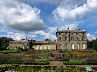
Allestree Hall is a 19th-century former country house situated in Allestree Park, Allestree, Derby. It is a Grade II* listed building but has been unoccupied for many years, and has been placed on the Heritage at Risk Register.

<span class="mw-page-title-main">Listed buildings in Crawley</span>

As of 2011 there were 102 listed buildings and structures in the English borough of Crawley, West Sussex. Two others have subsequently gained listed status. The Borough of Crawley is based on the town of the same name, located approximately halfway between London and Brighton. Although Crawley expanded substantially after World War II when it was designated a New Town by an Act of Parliament, many older buildings remain.

<span class="mw-page-title-main">Hangleton Manor Inn</span> Historic manor house in Hove, Sussex, England

Hangleton Manor Inn, the adjoining Old Manor House and associated buildings form a bar and restaurant complex in Hangleton, an ancient village which is part of the English city of Brighton and Hove. The manor house is the oldest secular building in the Hove part of the city; some 15th-century features remain, and there has been little change since the High Sheriff of Sussex rebuilt it in the mid-16th century. Local folklore asserts that a 17th-century dovecote in the grounds has been haunted since a monk placed a curse on it. The buildings that comprise the inn were acquired by Hangleton Manor Ltd in 1968, and converted to an inn under the Whitbread banner. The brewery company Hall & Woodhouse have owned and operated it since 2005. English Heritage has listed the complex at Grade II* for its architectural and historical importance, and the dovecote is listed separately at Grade II.

<span class="mw-page-title-main">Grade II listed buildings in Brighton and Hove: C–D</span>

As of February 2001, there were 1,124 listed buildings with Grade II status in the English city of Brighton and Hove. The total at 2009 was similar. The city, on the English Channel coast approximately 52 miles (84 km) south of London, was formed as a unitary authority in 1997 by the merger of the neighbouring towns of Brighton and Hove. Queen Elizabeth II granted city status in 2000.

<span class="mw-page-title-main">Listed buildings in Rivington</span>

Rivington in the Borough of Chorley, Lancashire, is situated on the edge of the West Pennine Moors, at the foot of Rivington Pike overlooking reservoirs created for Liverpool Corporation Waterworks in the 19th century. There are twenty eight listed buildings within Rivington, two are classified by English Heritage as Grade II*, the rest as Grade II; Rivington has no Grade I Listed buildings.

Astley is a settlement in the Metropolitan Borough of Wigan in Greater Manchester, England. Originally a village, it now forms a continuous urban area with Tyldesley to the north. It lies on flat land north of Chat Moss and is crossed by the Bridgewater Canal and the A580 "East Lancashire Road". Astley contains several listed buildings designated by English Heritage and included in the National Heritage List for England. Most are listed at Grade II, the lowest of the three gradings given to listed buildings and is applied to "buildings of national importance and special interest".

As of February 2001, there were 1,124 listed buildings with Grade II status in the English city of Brighton and Hove. The total at 2009 was similar. The city, on the English Channel coast approximately 52 miles (84 km) south of London, was formed as a unitary authority in 1997 by the merger of the neighbouring towns of Brighton and Hove. Queen Elizabeth II granted city status in 2000.

Alvaston is an electoral ward in the city of Derby, England. The ward contains 14 listed buildings that are recorded in the National Heritage List for England. Of these, three are listed at Grade II*, the middle of the three grades, and the others are at Grade II, the lowest grade. The ward was initially a village, and it has grown to become a suburb of the city. Towards the north of the ward are the former Tri Junct Station and the Derby Railway Works, and associated with them are four listed buildings. Some of the oldest listed buildings, consisting of cottages and a farmhouse, are located near the original centre of the village. The other listed buildings include churches and associated structures, a former toll house, and a conference centre.

References

  1. 1 2 "Listed Buildings". English Heritage. 2010. Archived from the original on 26 January 2013. Retrieved 19 August 2011.
  2. Historic England. "Allestree Hall (1215234)". National Heritage List for England . Retrieved 18 December 2014.
  3. "English Heritage At Risk Register 2010" (PDF). English Heritage At Risk Register. English Heritage. Retrieved 15 December 2014.
  4. Historic England. "10 Cornhill (1216023)". National Heritage List for England . Retrieved 18 December 2014.
  5. Historic England. "Village pump (1216094)". National Heritage List for England . Retrieved 18 December 2014.
  6. Historic England. "8 Cornhill (1216103)". National Heritage List for England . Retrieved 18 December 2014.
  7. Historic England. "11-15 Cornhill (1216123)". National Heritage List for England . Retrieved 18 December 2014.
  8. Historic England. "The Hollies Farmhouse (1228936)". National Heritage List for England . Retrieved 18 December 2014.
  9. Historic England. "St Edmunds Church (1228939)". National Heritage List for England . Retrieved 18 December 2014.
  10. Historic England. "Ice House (1230649)". National Heritage List for England . Retrieved 18 December 2014.
  11. "Red Cow, St Edmunds Close, Allestree, 2000s". Picture the Past. Retrieved 22 December 2014.
  12. Historic England. "Red Cow (1229165)". National Heritage List for England . Retrieved 18 December 2014.
  13. Historic England. "Yew Tree Cottage (1216132)". National Heritage List for England . Retrieved 18 December 2014.
  14. Historic England. "Old School House (1287828)". National Heritage List for England . Retrieved 18 December 2014.
  15. Historic England. "The Farm (1228601)". National Heritage List for England . Retrieved 18 December 2014.
  16. 1 2 "Toll House, Kedleston Road, Derby, 1960s". Picture the Past. Retrieved 22 December 2014.
  17. Historic England. "Former Toll House (1287191)". National Heritage List for England . Retrieved 18 December 2014.
  18. Historic England. "Home Farm house (1228641)". National Heritage List for England . Retrieved 18 December 2014.
  19. Historic England. "The Green (1228602)". National Heritage List for England . Retrieved 18 December 2014.
  20. 1 2 Derby City Council. "Markeaton Park restoration project" (pdf). Retrieved 25 December 2014.
  21. Historic England. "Conservatory at Markeaton Park (1230498)". National Heritage List for England . Retrieved 18 December 2014.
  22. "Plans unveiled to restore Markeaton Park's historic orangery". Derby Evening Telegraph. 15 August 2012. Retrieved 25 December 2014.
  23. Derby City Council. "Markeaton Park Restoration Project" . Retrieved 25 December 2014.