Listed buildings
5540 Ullerslev
| Listing name | Image | Location | Coordinates | Description |
|---|---|---|---|---|
| Grønne Mølle | Grønne Møllevejen 2, 5540 Ullerslev | 55°20′8.56″N10°40′41.05″E / 55.3357111°N 10.6780694°E | Mill and farmhouse. From 1843. Protected 1989. [1] [2] | |
| Grønne Møllevejen 2, 5540 Ullerslev | 55°20′8.56″N10°40′41.05″E / 55.3357111°N 10.6780694°E | Northern building. From 1830. [3] | ||
| Grønne Møllevejen 2, 5540 Ullerslev | 55°20′8.56″N10°40′41.05″E / 55.3357111°N 10.6780694°E | Western building. From 1830. [4] | ||
| Grønne Møllevejen 2, 5540 Ullerslev | 55°20′8.56″N10°40′41.05″E / 55.3357111°N 10.6780694°E | Eastern building. From 1830. [5] | ||
| Risinge | Risingevej 7A, 5540 Ullerslev | 55°24′39.22″N10°42′47.53″E / 55.4108944°N 10.7132028°E | North wing and dairy building. Protected 1989. [6] [7] | |
| Risingevej 7B, 5540 Ullerslev | 55°24′38.16″N10°42′46.44″E / 55.4106000°N 10.7129000°E | Main building. [8] | ||
| Risingevej 7C, 5540 Ullerslev | 55°24′37.33″N10°42′46.28″E / 55.4103694°N 10.7128556°E | South wing. [9] | ||
5800 Nyborg
| Listing name | Image | Location | Coordinates | Description |
|---|---|---|---|---|
| Aunslev Hospital |  | Aunslev Kirkevej 3, 5800 Nyborg | 55°21′17.68″N10°42′45.22″E / 55.3549111°N 10.7125611°E | From 1755. Protected 1932. [10] |
| Blegdamsgade 7 |  | Blegdamsgade 7, 5800 Nyborg | 55°18′50.65″N10°47′12.77″E / 55.3140694°N 10.7868806°E | Front building. From 1827. Protected 1959. [11] [12] |
| Blegdamsgade 7B, 5800 Nyborg | 55°18′50.32″N10°47′13.03″E / 55.3139778°N 10.7869528°E | Back building. From 1827. [13] | ||
| Blegdamsgade 7, 5800 Nyborg | 55°18′50.65″N10°47′12.77″E / 55.3140694°N 10.7868806°E | Back building. From 1786. [14] | ||
| Blegdamsgade 14 | Blegdamsgade 14, 5800 Nyborg | 55°18′50.18″N10°47′10.00″E / 55.3139389°N 10.7861111°E | Front building. From 1740. Protected 1964. [15] [16] | |
| Blegdamsgade 14A, 5800 Nyborg | 55°18′50.22″N10°47′9.25″E / 55.3139500°N 10.7859028°E | Back building, two sheds and canopy. From 1770. [17] | ||
| Castle Miller's House Slotsmøllerens Hus |  | Torvet 10, 5800 Nyborg | 55°18′47.19″N10°47′21.61″E / 55.3131083°N 10.7893361°E | Protected 1987. [18] |
| Dyrehave Mill Dyrehave Mølle |  | Dyrehavevej 84, 5800 Nyborg | 55°18′4.48″N10°46′49.58″E / 55.3012444°N 10.7804389°E | Protected 1959. [19] |
| Former iceboat station Den tidligere isbådsstation | Fyrvej 1A, 5800 Nyborg | 55°17′33.47″N10°50′51.29″E / 55.2926306°N 10.8475806°E | From 1827. Protected 1950. [20] | |
| Gyldencrone Mansion |  | Kongegade 1, 5800 Nyborg | 55°18′42.12″N10°47′19.86″E / 55.3117000°N 10.7888500°E | Protected 1919. [21] |
| Harbour Toll House Havnetoldkammeret |  | Havnegade 2, 5800 Nyborg | 55°18′35.71″N10°47′31.96″E / 55.3099194°N 10.7922111°E | From 1856. Protected 1950. [22] |
| Hindemae | Hindemaevej 86, 5540 Ullerslev | 55°20′51.22″N10°39′51.34″E / 55.3475611°N 10.6642611°E | Main building. From 1790. Protected 1939. [23] | |
| Holckenhavn Castle Holckenhavn |  | Holckenhavn 1, 5800 Nyborg | 55°17′33.52″N10°46′31.14″E / 55.2926444°N 10.7753167°E | Manor house from the 16th century. [24] |
| Jacob Encke House | Kongegade 12, 5800 Nyborg | 55°18′41.07″N10°47′26.48″E / 55.3114083°N 10.7906889°E | Western side building. From 1799. [25] [26] | |
| Kongegade 12, 5800 Nyborg | 55°18′41.07″N10°47′26.48″E / 55.3114083°N 10.7906889°E | Back building. From 1799. [27] | ||
| Kongegade 12, 5800 Nyborg | 55°18′41.07″N10°47′26.48″E / 55.3114083°N 10.7906889°E | Eastern side building. From 1897. [28] | ||
| Kongegade 12, 5800 Nyborg | 55°18′41.07″N10°47′26.48″E / 55.3114083°N 10.7906889°E | Front building. From 1799. [29] | ||
| Juelsberg | Juelsbergvej 11, 5800 Nyborg | 55°20′30.22″N10°45′50.12″E / 55.3417278°N 10.7639222°E | Manor house. Main building. From 1770. Protected 1918. [30] [31] | |
| Juelsbergvej 11, 5800 Nyborg | 55°20′30.22″N10°45′50.12″E / 55.3417278°N 10.7639222°E | Pavilion and ice house. From 1835. [32] | ||
| Juelsbergvej 11B, 5800 Nyborg | 55°20′29.37″N10°45′51.71″E / 55.3414917°N 10.7643639°E | Western building. From 1850. [33] | ||
| Juelsbergvej 11C, 5800 Nyborg | 55°20′29.15″N10°45′49.11″E / 55.3414306°N 10.7636417°E | Eastern building. From 1850. [34] | ||
| Juelsberg Optical Telegraph Juelsberg Optisk Telegraf | Telegrafvej 2, 5800 Nyborg | 55°18′56.04″N10°46′32.33″E / 55.3155667°N 10.7756472°E | Protected 1950. [35] | |
| Kalentegården |  | Korsgade 2, 5800 Nyborg | 55°18′43.39″N10°47′24.08″E / 55.3120528°N 10.7900222°E | Protected 1919. [36] |
| Kongegade 24 | Kongegade 24, 5800 Nyborg | 55°18′40.93″N10°47′31.2″E / 55.3113694°N 10.792000°E | From 1797. Protected 1919. Former pharmacy. [37] | |
| Korsbrødregården | Adelgade 1, 5800 Nyborg | 55°18′40.59″N10°47′33.97″E / 55.3112750°N 10.7927694°E | From around 1600. [38] [39] | |
| Korsbrødregade 2, 5800 Nyborg | 55°18′40.41″N10°47′33.25″E / 55.3112250°N 10.7925694°E | From around 1300. [40] | ||
| Korsgade 4 | Korsgade 4, 5800 Nyborg | 55°18′42.52″N10°47′24.1″E / 55.3118111°N 10.790028°E | Protected 1919. [41] | |
| Kullerup Rectory Kullerup Præstegård | Ferritslevvej 28A, 5800 Nyborg | 55°19′0.87″N10°42′26.57″E / 55.3169083°N 10.7073806°E | From 1760. Protected 1954. [42] | |
| Mads Lerche House |  | Slotsgade 11, 5800 Nyborg | 55°18′41.72″N10°47′18.87″E / 55.3115889°N 10.7885750°E | Protected 1918. [43] |
| Nyborg Castle Nyborg Slot |  | Slotsgade 37, 5800 Nyborg | 55°18′45.78″N10°47′12.35″E / 55.3127167°N 10.7867639°E | From 1170. [44] [45] |
| Slotsgade 36, 5800 Nyborg | 55°18′45.86″N10°47′15.66″E / 55.3127389°N 10.7876833°E | Gunpowder storehouse. From 1170. [46] | ||
| Nyborg Fortifications Nyborg Volde | Lindealleen 1, 5800 Nyborg | 55°18′51.16″N10°47′19.87″E / 55.3142111°N 10.7888528°E | Fortifications, gates and storehouse. Protected 1918. [47] [48] | |
| Lindealleen 1, 5800 Nyborg | 55°18′51.16″N10°47′19.87″E / 55.3142111°N 10.7888528°E | Gate building. [49] | ||
| Nyborg Library Nyborg Bibliotek |  | Torvet 11, 5800 Nyborg | 55°18′44.79″N10°47′19.36″E / 55.3124417°N 10.7887111°E | Protected 1986. [50] |
| Nyborg Rectory |  | Korsbrødregade 4, 5800 Nyborg | 55°18′40.56″N10°47′35.09″E / 55.3112667°N 10.7930806°E | Building from ca 1400. Protected 1918. [51] |
| Nyborg Town Hall Nyborg Rådhus |  | Torvet 1, 5800 Nyborg | 55°18′45.7″N10°47′24.86″E / 55.312694°N 10.7902389°E | Building from 1585-1586, rebuilt in 1803. Protected 1919. [52] |
| Nyborg Water Tower Nyborg Vandtårn |  | Møllebakken 10, 5800 Nyborg | 55°18′51.31″N10°47′4.48″E / 55.3142528°N 10.7845778°E | Water tower. From 1899. Protected 1997. [53] |
| Rasmus Møller House |  | Nørregade 1, 5800 Nyborg | 55°18′44.93″N10°47′26.47″E / 55.3124806°N 10.7906861°E | Protected 1920. [54] |
| Skippergade 26 |  | Skippergade 26, 5800 Nyborg | 55°18′39.48″N10°47′38.1″E / 55.3109667°N 10.793917°E | Protected 1989. [55] |
| Skippergade 26 A-D |  | Skippergade 26 A, 5800 Nyborg | 55°18′39.6″N10°47′38.55″E / 55.311000°N 10.7940417°E | Protected 1919. [56] |
| Slipshavn Pilot Station Slipshavn Lodsstation | Slipshavnsvej 51, 5800 Nyborg | 55°17′9.91″N10°49′32.75″E / 55.2860861°N 10.8257639°E | Protected 1978. [57] | |
| Slotsgade 13 |  | Slotsgade 13, 5800 Nyborg | 55°18′41.75″N10°47′17.9″E / 55.3115972°N 10.788306°E | Protected 1987. [58] |
| Slotsgade 15 |  | Slotsgade 15, 5800 Nyborg | 55°18′41.82″N10°47′17.33″E / 55.3116167°N 10.7881472°E | Protected 1924. [59] |
| Vindinge Church Barn Vindinge Kirkelade | Bøjdenvej 116A, 5800 Nyborg | 55°18′34.08″N10°43′58.8″E / 55.3094667°N 10.733000°E | Protected 1945. [60] | |
| Vindinge Engine House Vindinge Sprøjtehus | Rosildevænget 8M, 5800 Nyborg | 55°18′27.86″N10°43′45.5″E / 55.3077389°N 10.729306°E | Protected 1989. [61] |
5853 Ørbæk
| Listing name | Image | Location | Coordinates | Description |
|---|---|---|---|---|
| Glorup Manor Glorup | 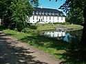 | Glorupvej 34, 5853 Ørbæk | 55°12′22.68″N10°42′27.79″E / 55.2063000°N 10.7077194°E | Main building. From ca. 1580. Protected 1918. [62] [63] |
 | Glorupvej 34, 5853 Ørbæk | 55°12′22.68″N10°42′27.79″E / 55.2063000°N 10.7077194°E | Pavilion. From 1870. [64] | |
| Juulskov | Juulskovvej 12, 5853 Ørbæk | 55°18′1.74″N10°41′15.52″E / 55.3004833°N 10.6876444°E | Protected 1918. [65] | |
| Little Mill Lille Mølle |  | Lillemøllevej 14, 5853 Ørbæk | 55°17′2.57″N10°42′16.42″E / 55.2840472°N 10.7045611°E | Watermill. From 1827. [66] [67] |
| Lillemøllevej 14, 5853 Ørbæk | 55°17′2.57″N10°42′16.42″E / 55.2840472°N 10.7045611°E | Western barn. From 1827. [68] | ||
| Lillemøllevej 14, 5853 Ørbæk | 55°17′2.57″N10°42′16.42″E / 55.2840472°N 10.7045611°E | Farmhouse. From 1827. [69] | ||
| Lillemøllevej 14, 5853 Ørbæk | 55°17′2.57″N10°42′16.42″E / 55.2840472°N 10.7045611°E | North-western barn. From 1827. [70] | ||
| Lillemøllevej 14, 5853 Ørbæk | 55°17′2.57″N10°42′16.42″E / 55.2840472°N 10.7045611°E | North-eastern barn. From 1827. [71] | ||
| Lykkesholm | Lykkesholmsvej 20, 5853 Ørbæk | 55°14′21.62″N10°37′5.68″E / 55.2393389°N 10.6182444°E | Manor house. Central main building. From 1668. Protected 1918. [72] [73] | |
| Lykkesholmsvej 20, 5853 Ørbæk | 55°14′21.62″N10°37′5.68″E / 55.2393389°N 10.6182444°E | Main building side wings. From 1786. [74] | ||
| Lykkesholmsvej 20, 5853 Ørbæk | 55°14′21.62″N10°37′5.68″E / 55.2393389°N 10.6182444°E | Gate. From 1640. [75] | ||
| Ravnholt | Ravnholtvej 57, 5853 Ørbæk | 55°15′39.09″N10°34′54.96″E / 55.2608583°N 10.5819333°E | Main building. Protected 1932. [76] [77] | |
| Ravnholtvej 57, 5853 Ørbæk | 55°15′39.09″N10°34′54.96″E / 55.2608583°N 10.5819333°E | Cross building. [78] | ||
| Rygård | Rygårdsvej 28, 5874 Hesselager | 55°11′33.12″N10°41′59.03″E / 55.1925333°N 10.6997306°E | Manor house. Protected 1918. [79] | |
| Sentvedvej 1 | Sentvedvej 1, 5853 Ørbæk | 55°15′15.84″N10°40′17.61″E / 55.2544000°N 10.6715583°E | Farmhouse. From 1650. Protected 1982. [80] [81] | |
| Sentvedvej 1, 5853 Ørbæk | 55°15′15.84″N10°40′17.61″E / 55.2544000°N 10.6715583°E | Shed. From 1650. [82] | ||
| Svindinge Hospital | Svendborgvej 71, 5853 Ørbæk | 55°12′59.36″N10°41′15.92″E / 55.2164889°N 10.6877556°E | Protected 1964. [83] | |
| Ørbæklunde | Ørbæklundevej 1, 5853 Ørbæk | 55°14′44.47″N10°40′10.49″E / 55.2456861°N 10.6695806°E | Manor house. Main building and east wing. From 1593. [84] [85] | |
| Ørbæklundevej 1, 5853 Ørbæk | 55°14′44.47″N10°40′10.49″E / 55.2456861°N 10.6695806°E | South and east wings. From 1730. [86] | ||
| Ørbæklundevej 1, 5853 Ørbæk | 55°14′44.47″N10°40′10.49″E / 55.2456861°N 10.6695806°E | Barn. From 1732. [87] | ||
| Ørbæklundevej 5, 5853 Ørbæk | 55°14′43.9″N10°40′6.22″E / 55.245528°N 10.6683944°E | Southern gable. From 1732. [88] |