Upper Hutt is a city in the Wellington Region of the North Island of New Zealand, and one of the four cities that constitute the Wellington metropolitan area.

The Hutt River flows through the southern North Island of New Zealand. It flows south-west from the southern Tararua Range for 56 kilometres (35 mi), forming a number of fertile floodplains, including Kaitoke, central Upper Hutt and Lower Hutt.

The Akatarawa River is in the lower North Island of New Zealand.

Palliser Bay is at the southern end of the North Island of New Zealand, to the southeast of Wellington. It runs for 40 kilometres along the Cook Strait coast from Turakirae Head at the southern end of the Rimutaka Ranges to Cape Palliser, the North Island's southernmost point.

Waikanae River is located on the Kapiti Coast in the North Island of New Zealand.

Reikorangi is a rural locality on the Kapiti Coast in New Zealand's North Island. It is inland, behind Waikanae in the Akatarawa Valley of the Tararua Ranges. The Ngatiawa River and Reikorangi Stream both meet the Waikanae River in Reikorangi. Reikorangi contains a church, a monastery, and formerly contained a school, which closed in 1970 due to the declining population of the small locality.
The Reikorangi Stream is a stream on the Kapiti Coast of New Zealand's North Island. It is one of the Waikanae River's major tributaries. Its headwaters are in the Tararua Ranges near Maungakotukutuku, and it flows north to Reikorangi in the Akatarawa Valley, where it meets the Waikanae River.
The Ngatiawa River is a river on the Kapiti Coast of New Zealand's North Island that is a major tributary of the Waikanae River. Its headwaters are in the Tararua Range and it flows north and northwest through the Akatarawa Valley to Reikorangi, where it meets the Waikanae River.

The Akatarawa Valley is a valley in the Tararua Range of New Zealand's North Island. It provides a link from the upper reaches of the Hutt Valley to Waikanae on the Kapiti Coast through rugged hill country. The valley is lowly populated and contains the localities of Reikorangi and Cloustonville. At the Hutt Valley end, the Akatarawa Valley is rugged and the Akatarawa River flows through it. The terrain is less difficult at the Kapiti end, where the Waikanae River flows through part of the valley on its route from its headwaters in the Tararuas to the Tasman Sea, and is met in the valley by tributaries such as the Ngatiawa River and the Reikorangi Stream.

Birchville is a suburb of Upper Hutt, New Zealand in the North Island. Its centre lies at the entrance to the Akatarawa Valley, in the north of the city, near confluence of the Akatarawa Stream with the Hutt River. It is about a 5 km (10-minute) drive north from the centre of Upper Hutt. The Birchville community is spread out along both banks of the Hutt River in a long fairly narrow valley.
The Ohura River is a river of the western North Island of New Zealand. It flows southward from its source close to the town of Ohura, and flows into the Whanganui River.

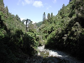
Karapoti Gorge is one of the entrances into the Akatarawa Forest, a regional park in the Wellington Region in New Zealand. The Akatarawa River West runs through this narrow, mostly bush-clad gorge towards the Akatarawa Valley. A narrow road winds its way along the steep slopes, providing access for trail biking, mountain biking and walking. Karapoti Gorge is also the starting leg of the annual Karapoti Classic mountain bike event, which runs on the network of tracks in the Akatarawa Forest.
The Manganui o te Ao River is a river of the centre of New Zealand's North Island. It has its source in numerous streams and small rivers which flow west from the slopes of Mount Ruapehu, though the main course of the river flows predominantly southwest through rugged hill country to meet with the Whanganui River 10 kilometres (6 mi) north of Pipiriki, at the edge of the Whanganui National Park.
The Mangatawhiri River is a river of the Auckland and Waikato Regions of New Zealand's North Island. It flows generally southwest from its sources in the Hunua Ranges southeast of Clevedon before flowing through a system of irrigation canals at the northern edge of the Waikato Plains close to the town of Pokeno. It reaches the Waikato River close to the township of Mercer.
The Motunau River is a river of the north Canterbury Region of New Zealand's South Island. It flows south-east from coastal hills south-west of Cheviot, reaching the Pacific Ocean at Motunau Beach at the northern tip of Pegasus Bay.
The Whakatahine River is a river of the Wellington Region of New Zealand's North Island. It flows generally northwest from its source in rough hill country southeast of Masterton before turning southwest to reach the Wainuiora River.
The Whakatikei River is a river of the Wellington Region of New Zealand's North Island. It flows generally southeast from its sources close to the west coast, 5 kilometres (3 mi) southeast of Paekakariki, and reaches the Hutt River at Upper Hutt.
The Wharepapa River is a river of the Wellington Region of New Zealand's North Island. It flows south from its sources within Remutaka Forest Park to reach the western end of Palliser Bay close to the small settlement of Wharekauhau.

Price's Bush Tramway was around 1903 bush railway near Akatarawa in the Tararua Range of New Zealand's North Island with a raised third rail for braking the loaden trucks like on the Rimutaka Incline.

The May Morn Estates Tramway was a bush railway at Mangaroa, which crossed the Hutt River at Te Marua near Upper Hutt on New Zealand's North Island. The company was incorporated in 1912 and operated their saw mill at least from 1914 to 1915.


