
Lake Huron is one of the five Great Lakes of North America. Hydrologically, it comprises the easterly portion of Lake Michigan–Huron, having the same surface elevation as its westerly counterpart, to which it is connected by the 5-mile-wide (8.0 km), 20-fathom-deep Straits of Mackinac. It is shared on the north and east by the Canadian province of Ontario and on the south and west by the state of Michigan in the United States. The name of the lake is derived from early French explorers who named it for the Huron people inhabiting the region. The Huronian glaciation was named due to evidence collected from Lake Huron region. The northern parts of the lake include the North Channel and Georgian Bay. Across the lake to the southwest is Saginaw Bay. The main inlet is the St. Marys River, and the main outlet is the St. Clair River.

Hemlock is an unincorporated community in Richland Township, Saginaw County in the U.S. state of Michigan. It is also a census-designated place (CDP) for statistical purposes, but without any legal status as an incorporated municipality. The population of the CDP was 1,585 at the 2000 census. The area included in the CDP is in the south central portion of Richland Township. The Hemlock post office, with ZIP code 48626, serves nearly all of Richland Township, as well as portions of Fremont Township to the south, small areas of Thomas and Swan Creek townships to the southeast, and part of Ingersoll Township to the north in Midland County.

The Huron-Manistee National Forests are two separate national forests, the Huron National Forest and the Manistee National Forest, combined in 1945 for administration purposes and which comprise 978,906 acres (3,960 km2) of public lands, including 5,786 acres (23 km2) of wetlands, extending across the northern lower peninsula of Michigan. The Huron-Manistee National Forests provide recreation opportunities for visitors, habitat for fish and wildlife, and resources for local industry. The headquarters for the forests is in Cadillac, Michigan.

The Porcupine Mountains, or Porkies, are a group of small mountains spanning the northwestern Upper Peninsula of Michigan in Ontonagon and Gogebic counties, near the shore of Lake Superior. The Porcupine Mountains were named by the native Ojibwa people, supposedly because their silhouette had the shape of a crouching porcupine. They are home to the most extensive stand of old growth northern hardwood forest in North America west of the Adirondack Mountains, spanning at least 31,000 acres (13,000 ha). In these virgin forests, sugar maple, American basswood, eastern hemlock, and yellow birch are the most abundant tree species. The area is part of the Porcupine Mountains Wilderness State Park.

The Yellow Dog River flows through Marquette County in the Upper Peninsula of the U.S. state of Michigan. It is 31.6 miles (50.9 km) in length, with about 85 miles (137 km) of tributaries. The main branch begins at the outflow from Bulldog Lake in the Ottawa National Forest on the boundary between Baraga and Marquette counties. The river's mouth is on Lake Independence, near Big Bay, Michigan, and is part of the Lake Superior watershed.
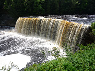
The Tahquamenon River is an 89.1-mile-long (143.4 km) blackwater river in the U.S. state of Michigan that flows in a generally eastward direction through the eastern end of the Upper Peninsula. It drains approximately 820 square miles (2,120 km2) of the Upper Peninsula, including large sections of Luce County and Chippewa County. It begins in the Tahquamenon Lakes in northeast Columbus Township of Luce County and empties into Lake Superior near the village of Paradise. M-123 runs alongside a portion of the river.

J.W. Wells State Park is a state park in the U.S. state of Michigan. The 678-acre (2.74 km2) park is located in Menominee County on the shore of Lake Michigan's Green Bay, just south of Cedar River. It is on M-35, roughly midway between Menominee and Escanaba. It was added to the National Register of Historic Places in 2002.
The Shelldrake River is a 32-mile-long (51 km) river in Chippewa County on the Upper Peninsula of Michigan in the United States. It flows through Tahquamenon Falls State Park and the Lake Superior State Forest into Lake Superior.
The Hemlock Society was an American right-to-die and assisted suicide advocacy organization which existed from 1980 to 2003. It was co-founded in Santa Monica, California by British author and activist Derek Humphry, his wife Ann Wickett Humphry (1942-1991), Gerald A. Larue, and Faye Girsh. It relocated to Oregon in 1988 and, according to Humphry, had several homes over its life. The group took its name from Conium maculatum, a highly poisonous biennial herbaceous flowering plant in the carrot family. The choice of the name is a direct reference to the method by which the Athenian philosopher Socrates took his life in 399 B.C. as described in Plato's Phaedo. It is not a firsthand account; the alleged event was told to Plato by one of Socrates' students, Phaedo of Elis.
The Rogue–Umpqua Divide Wilderness is a wilderness area located in the Rogue River – Siskiyou and Umpqua National Forests in the Klamath Mountains of Oregon, United States. It was established by the United States Congress in 1984 and comprises 33,200 acres (13,400 ha).

Michigan consists of two peninsulas that lie between east longitude, and are separated by the Straits of Mackinac, and some nearby islands. With the exception of two small areas that are drained by the Mississippi River by way of the Wisconsin River in the Upper Peninsula and by way of the Kankakee-Illinois River in the Lower Peninsula, Michigan is drained by the Great Lakes-St. Lawrence watershed and is the only state with the majority of its land thus drained.

The Mill River is a 16.3-mile (26.2 km) river in the town of Fairfield, Connecticut. It flows into Long Island Sound at Southport harbor.

Hemlock Gorge Reservation is a state-owned, public recreation area and urban wild comprising 16 acres (6.5 ha) on the Charles River in Newton and Needham, Massachusetts. The reservation is managed by the Massachusetts Department of Conservation and Recreation.

The Headwaters Wilderness is a 22,033-acre (89 km2) wilderness area located within the Nicolet unit of the Chequamegon-Nicolet National Forest in northeastern Wisconsin. It is the largest federally designated wilderness area on Wisconsin's mainland.

Hemlock Public School District is a school district headquartered in Hemlock, Michigan. It is a part of the Saginaw Intermediate School District, consists of 120 square miles (310 km2), and serves the Hemlock area, including Richland Township, western Thomas Township and central Fremont Township. Its schools include Hemlock Elementary School, K.C. Ling Elementary School, Hemlock Middle School, and Hemlock High School.

The Pigeon River is a small river flowing to Lake Michigan on the western Lower Peninsula of the U.S. state of Michigan. The river is approximately 12.9 miles (20.8 km) long and drains an area of 61.7 square miles (160 km2) in a generally rural area situated between the cities of Holland and Grand Haven. Via Lake Michigan and the larger Great Lakes system, it is part of the watershed of the St. Lawrence River.

Hemlock Hill is a mountain located in Central New York Region of New York southwest of Hartwick, New York.
