Keene is an unincorporated community in Albemarle County, Virginia, United States. As of the 1990 census, the town had a total population of 10.

The Little Missouri River is a tributary of the Missouri River, 560 miles (901 km) long, in the northern Great Plains of the United States. Rising in northeastern Wyoming, in western Crook County about 15 miles (24 km) west of Devils Tower, it flows northeastward, across a corner of southeastern Montana, and into South Dakota. In South Dakota, it flows northward through the Badlands into North Dakota, crossing the Little Missouri National Grassland and both units of Theodore Roosevelt National Park. In the north unit of the park, it turns eastward and flows into the Missouri in Dunn County at Lake Sakakawea, where it forms an arm of the reservoir 30 miles (48 km) long called Little Missouri Bay and joins the main channel of the Missouri about 25 miles (40 km) northeast of Killdeer.

Jordanville is a hamlet in the town of Warren, Herkimer County, New York, United States. Jordanville is in the northwestern part of Warren, at the intersection of New York State Route 167 and County Route 155. The community was settled by European Americans after the Revolutionary War and before 1791. Its name was derived from the nearby Ocquionis Creek, which was used by settlers for baptisms and likened by them to the Jordan River.

White Butte is the highest natural point in the U.S. state of North Dakota. At an elevation of 3,506 ft, it is a prominent butte in Slope County, in the Badlands of the southwestern part of the state. It is located 3 miles east of U.S. 85 and about 6.5 mi (10 km) south of Amidon.

Sagamore Hill was the home of the 26th president of the United States, Theodore Roosevelt, from 1885 until his death in 1919. It is located in Cove Neck, New York, near Oyster Bay on the North Shore of Long Island, 25 miles (40 km) east of Manhattan. It is now the Sagamore Hill National Historic Site, which includes the Theodore Roosevelt Museum in a later building on the grounds.

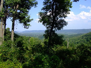
Theodore Roosevelt National Park is an American national park of the badlands in western North Dakota comprising three geographically separated areas. Honoring U.S. President Theodore Roosevelt, it is the only American national park named directly after a single person.
The Square Deal was Theodore Roosevelt's domestic program, which reflected his three major goals: conservation of natural resources, control of corporations, and consumer protection.

Theodore Roosevelt Island is an 88.5-acre (358,000 m2) island and national memorial located in the Potomac River in Washington, D.C. During the Civil War, it was used as a training camp for the United States Colored Troops. The island was given to the federal government by the Theodore Roosevelt Association in memory of the 26th president, Theodore Roosevelt. Until then, the island had been known as My Lord's Island, Barbadoes Island, Mason's Island, Analostan Island, and Anacostine Island.

The Theodore Roosevelt Bridge is a bridge crossing the Potomac River which connects Washington, D.C., with the Commonwealth of Virginia. The bridge crosses over Theodore Roosevelt Island, and carries Interstate 66/U.S. Route 50. The center lane in the bridge is reversible; the middle barrier is moved with a barrier transfer machine. It's operated eastbound during the morning rush hour from 6-11 am. The bridge is named in honor of Theodore Roosevelt, the 26th President of the United States.

Lake Tear of the Clouds is a small tarn located in the town of Keene, in Essex County, New York, United States, on the southwest slope of Mount Marcy, the state's highest point, in the Adirondack Mountains. It is the highest pond in the state at 4,293 feet (1,309 m). It is often cited as the highest source of the Hudson River, via Feldspar Brook, the Opalescent River and Calamity Brook.
Theodore Roosevelt Birthplace National Historic Site is a recreated brownstone at 28 East 20th Street, between Broadway and Park Avenue South, in the Flatiron District of Manhattan, New York City. It is a replica of the birthplace and childhood home of 26th president of the United States, Theodore Roosevelt.

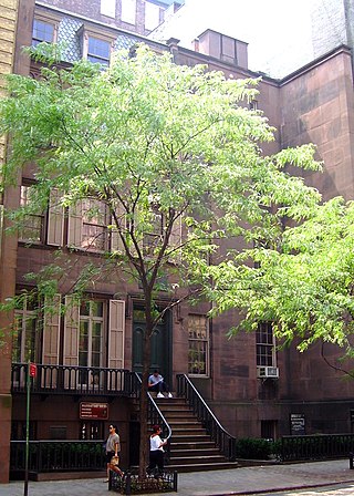
Theodore Roosevelt Inaugural National Historic Site preserves the Ansley Wilcox House, at 641 Delaware Avenue in Buffalo, New York. Here, after the assassination of William McKinley, Theodore Roosevelt took the oath of office as President of the United States on September 14, 1901. A New York historical marker outside the house indicates that it was the site of Theodore Roosevelt's Inauguration.
Shawnee State Park is a 1,095-acre (443 ha) public recreation area surrounded by the 63,000-acre (25,000 ha) Shawnee State Forest in Scioto County, Ohio, United States. The park is in the foothills of the Appalachian Mountains near the Ohio River in Southern Ohio on State Route 125, just north of Friendship.
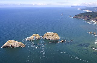
Three Arch Rocks National Wildlife Refuge is a U.S. National Wildlife Refuge off the northern Oregon Coast. It is located on the central coast of Tillamook County, in the northwestern part of Oregon. It is one of six National Wildlife Refuges within the Oregon Coast National Wildlife Refuge Complex and was the first National Wildlife Refuge west of the Mississippi River. In 1970 the Refuge was designated as wilderness. It is one of the smallest wilderness areas in the United States.

Crater Lake Lodge is a hotel built in 1915 to provide overnight accommodations for visitors to Crater Lake National Park in southern Oregon, US. The lodge is located on the southwest rim of the Crater Lake caldera overlooking the lake 1,000 feet (300 m) below. The lodge is owned by the National Park Service, and is listed on the National Register of Historic Places. In 2022, the hotel is a Historic Hotels of America program member, and has been so since 2012.

Chamisso Island is a small island in Kotzebue Sound, Alaska. It is located off Spafarief Bay at the mouth of Eschscholtz Bay, just south of the Choris Peninsula.
Sioux National Forest was a National Forest (NF) established by Executive Order 908 on July 1, 1908. The order called for the consolidation of the following national forests and forest units into a single entity:

Theodore Roosevelt State Natural Area is a 265-acre (1.07 km2) North Carolina state park in Carteret County, North Carolina, in the United States. Located on Bogue Banks, in the town of Pine Knoll Shores, the natural area protects the barrier island's only remaining intact maritime forest. It is bounded by NC 58 to the south, Bogue Sound to the north, and private development to the east and west.
Sully Creek State Park is a public recreation area located along the eastern banks of the Little Missouri River about two miles (3.2 km) south of Medora in Billings County, North Dakota. The state park is used for camping, horse camping, and canoeing.
