The Little Nokasippi River is a 13.8-mile-long (22.2 km) tributary of the Nokasippi River in Crow Wing County, Minnesota. It joins the Nokasippi just 1.0 mile (1.6 km) upstream from that river's mouth at the Mississippi River.
The Beaver River is a 23.4-mile-long (37.7 km) river in Lake County, Minnesota. It flows into Lake Superior.
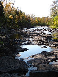
Big Sucker Creek is an 18.2-mile-long (29.3 km) river in St. Louis County, Minnesota, United States. It flows into Lake Superior.

The Caribou River is a 15.0-mile-long (24.1 km) river in northern Minnesota, the United States. It rises in a swamp about .6 miles (1 km) south of Morris Lake and two miles (3.2 km) east of Echo Lake, near the Lake/Cook County line, at an altitude about 1620 feet above sea level. It descends some 1,020 feet in elevation as it flows south to its mouth at Lake Superior, also near the eastern border of Lake County.
The French River is a 13-mile-long (21 km) river in Saint Louis County, Minnesota, United States, flowing into Lake Superior at the unincorporated community of French River in Duluth Township. The river also flows through Normanna and Lakewood townships.
The Knife River is a 23.9-mile-long (38.5 km) river of northern Minnesota which drains a portion of Lake and Saint Louis counties into Lake Superior between Duluth and Two Harbors.
The Little Elk River is a 29.4-mile-long (47.3 km) tributary of the Mississippi River in Morrison County, Minnesota, United States.
The Little Gooseberry River is a 4.8-mile-long (7.7 km) river in Lake County, Minnesota, United States. It is a tributary of the Gooseberry River.
The Little Knife River (East) is a 5.7-mile-long (9.2 km) river in Lake County, Minnesota, United States. It is a tributary of the Knife River, located northwest of the city of Two Harbors. A second Little Knife River flows into the Knife River from the west, through St. Louis County.
The Little Net River is a 12.1-mile-long (19.5 km) tributary of the Net River of Minnesota, part of the Nemadji River watershed flowing to Lake Superior.
The Little Pine River is a 29.7-mile-long (47.8 km) tributary of the Pine River of Minnesota in the United States. Via the Pine River it is part of the Mississippi River watershed. The Little Pine River begins in the northeast corner of Crow Wing County at the outlet of Little Pine Lake and flows southwest to its junction with the Pine River in Crow Wing State Forest.
The Little River is a 2.1-mile-long (3.4 km) stream in Carlton County, Minnesota, United States. It is a tributary of the Saint Louis River.
The Little Stewart River is an 8.9-mile-long (14.3 km) river in Lake County, Minnesota, United States. It is a tributary of the Stewart River.

The Little Sucker River is a 1.6-mile-long (2.6 km) stream in St. Louis County, Minnesota, flowing directly into Lake Superior.
The Little Whiteface River is a 4.4-mile-long (7.1 km) river of Minnesota and the southern of two tributaries of the Whiteface River with the same name.
The Little Willow River is a 26.2-mile-long (42.2 km) tributary of the Mississippi River in northern Minnesota, United States. It rises in western Aitkin County at the outlet of Esquagamah Lake and flows generally south to its junction with the Mississippi River 3 miles (5 km) northwest of Aitkin.
The Rice River is a 57.1-mile-long (91.9 km) tributary of the Mississippi River in northern Minnesota, United States. It rises in southeastern Aitkin County at the outlet of Porcupine Lake and flows generally north into Rice Lake National Wildlife Refuge, where it turns west and flows to the Mississippi 5 miles (8 km) northeast of Aitkin.
Skunk Creek is a 12.3-mile-long (19.8 km) stream in Lake County, Minnesota, United States. It is a tributary of the Gooseberry River.
The Talmadge River is a 6.0-mile-long (9.7 km) river in southern Saint Louis County, Minnesota, United States. It flows through Lakewood Township into Lake Superior, just north of the city of Duluth.
The Whiteface River is a 64.4-mile-long (103.6 km) tributary of the Saint Louis River in Saint Louis County, Minnesota, United States.


