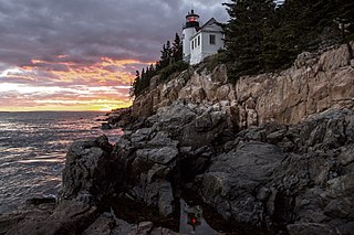
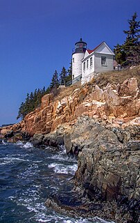
Acadia National Park is an American national park located along the mid-section of the Maine coast, southwest of Bar Harbor. The park preserves about half of Mount Desert Island, part of the Isle au Haut, the tip of the Schoodic Peninsula, and portions of 16 smaller outlying islands. It protects the natural beauty of the rocky headlands, including the highest mountains along the Atlantic coast. Acadia boasts a glaciated coastal and island landscape, an abundance of habitats, a high level of biodiversity, clean air and water, and a rich cultural heritage.
Sullivan is a town in Hancock County, Maine, United States. The population was 1,219 at the 2020 census. The town was named for Daniel Sullivan, an early settler. Colloquially referred to as "Sully" or "the Sullivans"—like many Maine municipalities composed of villages with geographic designations of the town proper—the municipality was incorporated in 1789. Located in the Upper Schoodic Peninsula sub-region of Maine's Downeast Acadia region, the municipality has been known as "Waukeag", "New Bristol", and later Sullivan; and once included the nearby communities of Hancock, Sorrento, and what would later be Township 7, South & Middle Districts. Once home to abundant granite quarries, the town of Sullivan is now a residential community for nearby Ellsworth and Mount Desert Island. Located along U.S. Route 1, the Taunton River, and Hog Bay, Sullivan is home to a reversing tidal falls and many scenic turnouts that dot the Schoodic National Scenic Byway along the Upper Schoodic Peninsula.
Mount Desert Island in Hancock County, Maine, is the largest island off the coast of Maine. With an area of 108 square miles (280 km2) it is the 52nd-largest island in the United States, the sixth-largest island in the contiguous United States, and the second-largest island on the Eastern Seaboard, behind Long Island and ahead of Martha's Vineyard. According to the 2010 census, the island has a year-round population of 10,615. In 2017, an estimated 3.5 million tourists visited Acadia National Park on MDI. The island is home to numerous well-known summer colonies such as Northeast Harbor and Bar Harbor.

The Virgin Islands National Park is an American national park preserving about 60% of the land area of Saint John in the United States Virgin Islands, as well as more than 5,500 acres of adjacent ocean, and nearly all of Hassel Island, just off the Charlotte Amalie, Saint Thomas harbor.

Marsh-Billings-Rockefeller National Historical Park is a United States National Historical Park in Woodstock, Vermont. The park preserves the Marsh-Billings House, as well as the site where Frederick Billings established a managed forest and a progressive dairy farm. The name honors Billings and the other owners of the property: George Perkins Marsh, Mary Montagu Billings French, Laurance Rockefeller, and Mary French Rockefeller. The Rockefellers transferred the property to the federal government in 1992. It is the only unit of the United States National Park System in Vermont.

Jordan Pond is an oligotrophic tarn in Acadia National Park near the town of Bar Harbor, Maine. The pond covers 187 acres (76 ha) to a maximum depth of 150 feet (46 m) with a shoreline of 3.6 miles (5.8 km).
The Marine Drive is a designated scenic route along Nova Scotia's Eastern Shore. It closely follows the coast of the Atlantic Ocean and the Strait of Canso from the Canso Causeway to the junction of Route 322 and Highway 111 in Dartmouth.

Sandy Point State Reservation is a coastal Massachusetts state park located in the town of Ipswich at the southern tip of Plum Island. The reservation is managed by the Department of Conservation and Recreation and is an important nesting area for the piping plover and the least tern. Access to the reservation is through the adjoining Parker River National Wildlife Refuge.

The Daniel Webster Wildlife Sanctuary is a sanctuary owned by the Massachusetts Audubon Society, the largest conservation organization in New England, in the town of Marshfield, Massachusetts. The sanctuary, formerly the farm of Edward Dwyer, statesman Daniel Webster and the William Thomas family of Marshfield, the first English landowner to live on the sanctuary land, was purchased by Mass Audubon in 1984 thanks to the volunteer efforts of the Committee for the Preservation of Dwyer Farm for the People of Marshfield. The sanctuary contains 507 acres (2.1 km2) of mixed cultural grasslands, red maple swamps, a five-tiered wet panne, Webster Pond and a section of the Green Harbor River. It is the site of the annual Daniel Webster Farm Day celebration. Surrounding lands owned by the town of Marshfield and the Marshfield Airport increase the local open space area to more than 1000 acres (4 km2).

The Watuppa Ponds are two large, naturally occurring, spring-fed, glacially formed ponds located in Fall River and Westport, Massachusetts. Watuppa is a native word meaning "place of boats". The two ponds were originally one body of water, connected by a narrow rocky straight called "The Narrows" located on a thin strip of land between the two ponds which forms part boundary of between Fall River and Westport. The border between Fall River and Westport is also divided between the two ponds. Together, the ponds have an overall north–south length of about 7.5 miles, and have an average east–west width of about a mile. The ponds are drained by the Quequechan River, and flows in a westerly direction through the center of Fall River from South Watuppa Pond to Mount Hope Bay.
Higby Mountain or Mount Higby 892 feet (272 m), is a traprock mountain ridge located 3.75 miles (6.04 km) east of Meriden, Connecticut. It is part of the narrow, linear Metacomet Ridge that extends from Long Island Sound near New Haven, Connecticut, north through the Connecticut River Valley of Massachusetts to the Vermont border. Higby Mountain is known for its high cliff faces, unique microclimate ecosystems, and rare plant communities. It rises steeply 600 feet (180 m) above the Quinnipiac River valley and the city of Meriden to the west as a continuous 2-mile (3 km) long ledge. The mountain is traversed by the 50-mile (80 km) Mattabesett Trail.

Saltonstall Mountain, also known as Saltonstall Ridge, with a high point of (est.) 320 feet (98 m) above sea level, is a traprock mountain ridge located 3 miles (5 km) east of New Haven, Connecticut and 1.75 miles (2.8 km) north of Long Island Sound. It is part of the Metacomet Ridge that extends from Long Island Sound near New Haven, Connecticut, north through the Connecticut River Valley of Massachusetts to the Vermont border. Saltonstall Mountain is known for its 100 foot (30 m) scenic cliff faces and sharp ridgeline, unique microclimate ecosystems, rare plant communities, and for Lake Saltonstall, a 3 miles (5 km) long by 0.3 miles (400 m) wide municipal reservoir nearly enclosed by the mountain. Saltonstall Mountain is traversed by a number of hiking trails managed by the South Central Connecticut Regional Water Authority (SCCRWA) and Branford Land Trust.
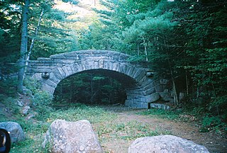
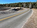
Acadia National Park, largely on Mount Desert Island, off the coast of the U.S. state of Maine, was created in part by land and other donations by John D. Rockefeller Jr. Between 1919 and 1931, Rockefeller, who was opposed to the introduction of automobiles on the island, personally oversaw the construction of a network of carriage roads, closed to motorized vehicles, on the eastern half of the island, including sixteen granite bridges and two gatehouses. The major portion of this network now falls within the bounds of the national park, and was listed on the National Register of Historic Places in 1979.

Carvers Creek State Park is a North Carolina state park in Cumberland County, North Carolina in the United States. Located north of Fayetteville, it covers 4,530 acres (18.3 km2) in the Sandhills region of the state. The park covers lands around Carvers Creek, a tributary of the Cape Fear River, and it borders Fort Bragg. The park is currently divided into two areas, Long Valley Farm and the Sandhills Property. The park is still being planned, and the state is planning to acquire more land for the park.
The Broadneck Peninsula is an area in Anne Arundel County, Maryland. The area is north of the Severn River, south of the Magothy River and west of the Chesapeake Bay. At the lower end of the Broadneck Peninsula is the 4.3 mile Chesapeake Bay Bridge.

Enchanted Pond is a mountain pond in the U.S. state of Maine. Situated in the Western Maine Mountains in the Northwest Somerset Region, the pond is located in a deep mountain valley between Coburn Mountain and Shutdown Mountain. Near its southern end, the pond is distinguished by two rockslides from the exposed cliffs of these mountains that extend down into the water along both shores. Enchanted Pond is fed by mountain springs and Little Enchanted Pond, and is the primary source of Enchanted Stream which flows into the Dead River, a tributary of the Kennebec River. Development on the pond is limited to a small set of sporting camps at the northern end of the pond and one remote camp on the southwest shore, both a part of Bulldog Camps. There are no islands in the pond.
Range Ponds State Park is a public recreation area wrapping around the eastern end of Lower Range Pond in the town of Poland in Androscoggin County, Maine. The state park offers a sandy beach with lifeguard-supervised swimming, kayaking, limited motorized boating, hiking trails, and fishing. Mountain biking trails, built with the help of local volunteers, provide intermediate level, single-track loops off a central double-track trail that winds through mature pine and hardwood forests.

Gifford Woods State Park is a state park located at the base of Pico Peak in Killington, Vermont. The wooded park provides camping, picnic, and fishing facilities, and has hiking trails, including a portion of the Appalachian Trail. It preserves an area of old-growth forest that has been designated a National Natural Landmark, and is accessible via an interpretive trail. The park was established in 1931. Part of it is listed on the National Register of Historic Places, for facilities developed by the Civilian Conservation Corps in the 1930s.

Jordan Pond House is a restaurant in Seal Harbor, Maine. It is situated at the southwestern corner of the Park Loop Road, overlooking Jordan Pond from its southern shore. Two rôche moutonnées, known as "The Bubbles", provide the backdrop to the view from the house's lawn at the rear of the 60-acre property.