
Acadia National Park is an American national park located along the mid-section of the Maine coast, southwest of Bar Harbor. The park preserves about half of Mount Desert Island, part of the Isle au Haut, the tip of the Schoodic Peninsula, and portions of 16 smaller outlying islands. It protects the natural beauty of the rocky headlands, including the highest mountains along the Atlantic coast. Acadia boasts a glaciated coastal and island landscape, an abundance of habitats, a high level of biodiversity, clean air and water, and a rich cultural heritage.
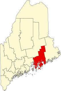
Hancock County is a county located in the U.S. state of Maine. As of the 2010 census, the population was 54,418. Its county seat is Ellsworth. The county was incorporated on June 25, 1789 and named for John Hancock, the first governor of the Commonwealth of Massachusetts. The Commissioners are William F. Clark, John Wombacher and Paul Paradis.

Ellsworth is a city in and the county seat of Hancock County, Maine, United States. The 2010 Census determined it had a population of 7,741. Ellsworth was Maine's fastest growing city from 2000–2010, with a growth rate of nearly 20 percent, but 2010-2014 saw only a gain of 102 people per Portland Press Herald data. Named after United States Founding Father Oliver Ellsworth, it contains historic buildings and other points of interest, and is close to Acadia National Park.

Frenchboro is a town in Hancock County, Maine, United States, and a village within this town located on Long Island, southeast of Swans Island - an island distinct from both the island town of Long Island in Cumberland County and the Long Island in Blue Hill Bay, southeast of Blue Hill Harbor. The population was 61 at the 2010 census.

Hancock is a town in Hancock County, Maine, United States. The population was 2,394 at the 2010 census. Located on the mainland at the head of Frenchman Bay, Hancock has commanding views of Mount Desert Island.
Sullivan is a town in Hancock County, Maine, United States. The population was 1,236 at the 2010 census. The town was named for Daniel Sullivan, an early settler. Colloquially referred to as "Sully" or "the Sullivans" – like many Maine municipalities composed of villages with geographic designations of the town proper – the municipality was incorporated in 1789. Located in the Upper Schoodic Peninsula sub-region of Maine's Downeast Acadia region, the municipality has been known as "Waukeag", "New Bristol", and later Sullivan; and once included the nearby communities of Hancock, Sorrento, and what would later be Township 7, South & Middle Districts. Once home to abundant granite quarries, the town of Sullivan is now a residential community for nearby Ellsworth and Mount Desert Island. Located along U.S. Route 1, the Taunton River, and Hog Bay, Sullivan is home to a reversing tidal falls and many scenic turnouts that dot the Schoodic National Scenic Byway along the Upper Schoodic Peninsula.
Bar Harbor is a town on Mount Desert Island in Hancock County, Maine, United States. As of the 2010 census, its population is 5,235. Bar Harbor is a popular tourist destination in the Down East region of Maine and home to the College of the Atlantic, Jackson Laboratory, Bar Harbor Bank & Trust, and MDI Biological Laboratory. Until a catastrophic fire in 1947, the town was a noted summer colony for the wealthy. Bar Harbor is home to the largest parts of Acadia National Park, including Cadillac Mountain, the highest point within twenty-five miles (40 km) of the coastline of the Eastern United States.

Mount Desert Island in Hancock County, Maine, is the largest island off the coast of Maine. With an area of 108 square miles (280 km2) it is the 52nd-largest island in the United States, the sixth-largest island in the contiguous United States, and the second-largest island on the Eastern Seaboard, behind Long Island and ahead of Martha's Vineyard. According to the 2010 census, the island has a year-round population of 10,615. In 2017, an estimated 3.5 million tourists visited Acadia National Park on MDI. The island is home to numerous well-known summer colonies such as Northeast Harbor and Bar Harbor.

Cadillac Mountain is located on Mount Desert Island, within Acadia National Park, in the U.S. state of Maine. With an elevation of 1,530 feet, its summit is the highest point in Hancock County and the highest within 25 miles (40 km) of the Atlantic shoreline of the North American continent between the Cape Breton Highlands, Nova Scotia and peaks in Mexico. It is known as the first place in the U.S. to see the sunrise, although that is only true for a portion of the year.

The Union River is a 21.9-mile-long (35.2 km) river that runs through Ellsworth, the county seat of Hancock County in eastern Maine. In the colonial era, it was known as the Mount Desert River.

Jordan Pond is an oligotrophic tarn in Acadia National Park near the town of Bar Harbor, Maine. The pond covers 187 acres (76 ha) to a maximum depth of 150 feet (46 m) with a shoreline of 3.6 miles (5.8 km).

The Mousam River is a 29.7-mile-long (47.8 km) river in York County, Maine, United States. Its primary source is Mousam Lake, located between the towns of Shapleigh and Acton, and it flows into the Atlantic Ocean just west of Kennebunk Beach. It flows through the towns of Shapleigh, Sanford and Kennebunk.
This is a list of the National Register of Historic Places listings in Hancock County, Maine.
The Baker Branch Saint John River is a 48.0-mile-long (77.2 km) river. This river is a tributary of the Saint John River, flowing in the Maine North Woods, in Maine, in the Northeastern United States.
The East Branch Union River is a 21.6-mile-long (34.8 km) river in Hancock County, Maine. From the outflow of Rocky Pond in Maine Township 22 M D, the river runs 5.3 miles (8.5 km) southwest to Spectacle Pond in Osborn. From the pond's outlet, the river runs 13.0 miles (20.9 km) northwest, southwest, west and southwest to Graham Lake, where it joins the West Branch to form the Union River. The lower section of the East Branch forms the border between Mariaville and Waltham.
The Jordan River is a 5-mile-long (8 km) tidal river in Hancock County, Maine, flowing to Mount Desert Narrows, the waterway that separates Mount Desert Island from the mainland. The Jordan River forms the boundary between the towns of Lamoine and Trenton.

The West Branch Penobscot River is a 117-mile-long (188 km) tributary of the Penobscot River through the North Maine Woods in Maine. The river is also known as Abocadneticook, Kahgognamock, and Kettegwewick.
The West Branch Union River is a river in Hancock County, Maine. From the outflow of Great Pond in the town of Great Pond, the river runs 20.1 miles (32.3 km) southwest and south to Graham Lake, where it joins the East Branch in Mariaville to form the Union River.

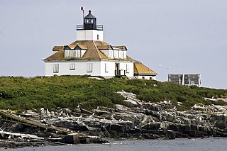
Great Duck Island Light is a lighthouse on Great Duck Island in the town of Frenchboro, Maine, USA. Established in 1890, the light marks the approach to Blue Hill Bay and the southern approaches to Mount Desert Island on the central coast of Maine. The light was listed on the National Register of Historic Places as Great Duck Island Light Station on March 14, 1988. The light is an active aid to navigation maintained by the United States Coast Guard; the property is owned by the College of the Atlantic, which operates a research station there.

Little Long Pond is a pond in Seal Harbor, Maine, United States, at the southern end of Mount Desert Island. Fed by Jordan Stream, a runoff of Jordan Pond, the pond is separated from Bracy Cove at the Gulf of Maine by a narrow causeway carrying State Route 3. It is officially called Long Pond, but has been given the Little prefix to differentiate it from other Long Ponds in the area. A 2.2 miles (3.5 km) trail circumnavigates the pond, while an offshoot leads to Jordan Pond House. Mostly flat on its eastern side, it rises somewhat from the pond's northern end to around halfway down its western side.


