The Regional District of Kootenay Boundary (RDKB) is one of 29 regional districts in the province of British Columbia, Canada. As of the 2016 census, the population was 31,447. The area is 8,095.62 km². The RDKB was incorporated in 1966 and consists of eight incorporated municipalities and five unincorporated electoral areas. The regional district's offices are in the City of Trail, with secondary offices in the City of Grand Forks. Other major population centres include the cities of Rossland and Greenwood, and the villages of Fruitvale, Warfield, and Montrose. The region also encompasses electoral areas A, B/Lower Columbia-Old Glory, C/Christina Lake, D/Rural Grand Forks and E/West Boundary including Rock Creek, Bridesville, Beaverdell and Big White Ski Resort.

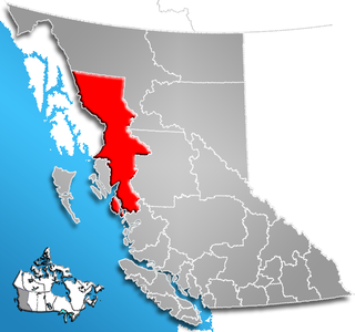
The Regional District of East Kootenay (RDEK) is a regional district in the Canadian province of British Columbia, Canada. At the 2016 census, the population was 60,439. Its area is 27,542.69 square kilometres. The regional district offices are in Cranbrook, the largest community in the region. Other important population centres include the cities of Kimberley and Fernie, and the district municipality of Invermere and Sparwood. Despite its name, the regional district does not include all of the region known as the East Kootenay, which includes the Creston Valley and the east shore of Kootenay Lake.

The Regional District of Bulkley-Nechako (RDBN) is a regional district in the Canadian province of British Columbia, Canada. As of the 2016 census, the population was 37,896. The area is 73,419.01 square kilometres. The regional district offices are in Burns Lake.

The Columbia-Shuswap Regional District is a regional district in the Canadian province of British Columbia, located in the Southern Interior region on the Trans-Canada Highway between Vancouver and Calgary, Alberta. The regional district borders the Province of Alberta across the Rocky Mountains.

The Cowichan Valley Regional District is a regional district in the Canadian province of British Columbia is on the southern part of Vancouver Island, bordered by the Nanaimo and Alberni-Clayoquot Regional Districts to the north and northwest, and by the Capital Regional District to the south and east. As of the 2011 Census, the Regional District had a population of 80,332. The regional district offices are in Duncan.
The Bonaparte Plateau, in British Columbia, Canada, is a subarea of the larger Cariboo Plateau which extends to the Quesnel River and lies between the Cariboo Mountains on the east and the Fraser River on the west. The Cariboo Plateau is a subarea of the Interior Plateau, aka the Fraser Plateau.

Canim Beach Provincial Park is a provincial park in British Columbia, Canada, located at the southwest end of Canim Lake in the Interlakes District of the South Cariboo region, adjacent to the Secwepemc Indian reserve community of Canim Lake, British Columbia just northeast of 100 Mile House. The park was established by Order-in-Council in 1956 and expanded by later legislation in 2000 and 2004 to total a current approximate of 8.2 hectares.
The Regional District of Kitimat-Stikine is a type of local government administration in northwestern British Columbia, Canada. As of the Canada 2001 Census it had a population of 40,876 living on a land area of 91,910.63 km². Its administrative offices are in the city of Terrace. The next-largest municipality in the regional district is the District Municipality of Kitimat. The other incorporated municipalities in the regional district are the Village of Hazelton, the District of New Hazelton and the District of Stewart. Unincorporated communities are many, most of them Indian Reserves which are not part of the governmental system of the regional district, which has limited powers relating mostly to municipal-type services. The remote settlement of Dease Lake, formerly in the Stikine Region, was added to the regional district on December 1, 2007.
Central Coast Regional District is a regional district in British Columbia, Canada. It has a total land area of 24,559.5 km². When it was created in 1968, it was named Ocean Falls Regional District, after the then-largest town in the region, the company town of Ocean Falls, which has since become a ghost town. The district name was confirmed in 1974, but changed to Central Coast Regional District in 1976.

The Bonaparte Indian Band a.k.a. Bonaparte First Nation, is a member band of the Shuswap Nation Tribal Council of the Secwepemc (Shuswap) people.
The Williams Lake Indian Band is a First Nations government of the Secwepemc (Shuswap) Nation, located in the Cariboo region of the Central Interior region of the Canadian province of British Columbia, at the city of Williams Lake. It was created when the government of the then-Colony of British Columbia established an Indian Reserve system in the 1860s. It is a member government of the Northern Shuswap Tribal Council. Its main Indian Reserve is Williams Lake Indian Reserve No. 1, a.k.a. "Sugarcane" or "The Cane" or "SCB".
The Alkali Lake Indian Band, also known as the Esketemc First Nation, is a First Nations government of the Secwepemc (Shuswap) people, located at Alkali Lake in the Cariboo region of the Central Interior of the Canadian province of British Columbia. It was created when the government of the then-Colony of British Columbia established an Indian Reserve system in the 1860s. It is one of three Secwepemc bands that is not a member of either the Shuswap Nation Tribal Council or the Northern Shuswap Tribal Council.
The Quesnel Highland is a geographic area in the Central Interior of the Canadian province of British Columbia. As defined by BC government geographer in Landforms of British Columbia, an account and analysis of British Columbia geography that is often cited as authoritative, the Highland is a complex of upland hill and plateau areas forming and defined as being the buffer between the Cariboo Plateau and the Cariboo Mountains, as a sort of highland foothills along the eastern edge of the Interior Plateau running southeast from a certain point southeast of the city of Prince George to the Mahood Lake area at the southeast corner of the Cariboo. Beyond Mahood Lake lies another separately classified area dubbed by Holland the Shuswap Highland which spans similar terrain across the North Thompson and Shuswap Lake-Adams River drainage basins, forming a similar upland-area buffer between the Thompson Plateau and the Monashee Mountains. A third area, the Okanagan Highland, extends from the southern end of the Shuswap Highland in the area of Vernon and Enderby in the northern Okanagan region into Washington State, and also abuts the Monashee Mountains.
The Blue River is a tributary of the North Thompson River in the South-Central Interior of British Columbia, Canada, located at and being the namesake of the community of the same name, approximately midway between the city of Kamloops and the Yellowhead Pass. The river flows NE to join the North Thompson after flowing generally east from Blue Lake, which is at a low pass with the basin of Murtle Lake and the Murtle River, which join the North Thompson via the Clearwater and the community of the same farther southwest. The Blue River forms part of the boundary between the Shuswap Highland (S) and the southwesternmost Cariboo Mountains (N).