The Alberni-Clayoquot Regional District of British Columbia is located on west central Vancouver Island. Adjacent regional districts it shares borders with are the Strathcona and Comox Valley Regional Districts to the north, and the Nanaimo and Cowichan Valley Regional Districts to the east. The regional district offices are located in Port Alberni.

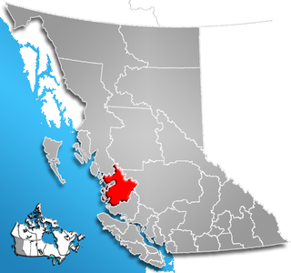
The Squamish-Lillooet Regional District is a quasi-municipal administrative area in British Columbia, Canada. It stretches from Britannia Beach in the south to Pavilion in the north. Lillooet, Pemberton, Whistler and Squamish are the four municipalities in the regional district. Its administrative offices are in the Village of Pemberton, although the district municipalities of Squamish, Whistler, and Lillooet are all larger population centres. The district covers 16,353.68 km² of land area.

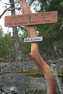
The qathet Regional District is a regional district in the Canadian province of British Columbia. It includes the City of Powell River and a number of unincorporated areas. The district encompasses a land area of 5,092.06 square kilometres (1,966.06 sq mi). Formerly known as the formerly the Powell River Regional District, its name was changed in 2018 to qathet, meaning "working together" in the language of the Tla'amin Nation.

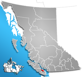
The Sunshine Coast Regional District of British Columbia is located on the southern mainland coast, across Georgia Strait from Vancouver Island. It borders on the Powell River Regional District to the north, the Squamish-Lillooet Regional District to the east, and, across Howe Sound, the Metro Vancouver District to the south. The regional district offices are located in the District Municipality of Sechelt.

The Regional District of East Kootenay (RDEK) is a regional district in the Canadian province of British Columbia, Canada. At the 2016 census, the population was 60,439. Its area is 27,542.69 square kilometres. The regional district offices are in Cranbrook, the largest community in the region. Other important population centres include the cities of Kimberley and Fernie, and the district municipality of Invermere and Sparwood. Despite its name, the regional district does not include all of the region known as the East Kootenay, which includes the Creston Valley and the east shore of Kootenay Lake.
The Regional District of Nanaimo is a regional district located on the eastern coast of Vancouver Island, British Columbia, Canada. It is bordered to the south by the Cowichan Valley Regional District, to the west by the Alberni-Clayoquot Regional District, and to the northwest by the Comox Valley Regional District. Its administration offices are located in Nanaimo. During the 2011 census, its population was established at 146,567.

The Columbia-Shuswap Regional District is a regional district in the Canadian province of British Columbia, located in the Southern Interior region on the Trans-Canada Highway between Vancouver and Calgary, Alberta. The regional district borders the Province of Alberta across the Rocky Mountains.

The Regional District of Comox-Strathcona was a regional district of British Columbia, Canada from 1967 to 2008. On February 15, 2008, the regional district was abolished and replaced by two successor regional districts, Comox Valley and Strathcona.

The Cowichan Valley Regional District is a regional district in the Canadian province of British Columbia is on the southern part of Vancouver Island, bordered by the Nanaimo and Alberni-Clayoquot Regional Districts to the north and northwest, and by the Capital Regional District to the south and east. As of the 2011 Census, the Regional District had a population of 80,332. The regional district offices are in Duncan.
Kin Beach Provincial Park is a natural provincial park in British Columbia, Canada, located just northwest of Kye Bay, to the north of Comox, British Columbia.

The Regional District of Mount Waddington (RDMW) is a regional district in British Columbia. It takes in the lower Central Coast region centred on the Queen Charlotte Strait coast of northern Vancouver Island and the adjoining parts of mainland British Columbia. It has a total land area of 20,288.4 km² and a 2016 census population of 11,035 persons, most of which is in towns on Vancouver Island and adjoining islands. The administrative centre is in the town of Port McNeill. Other municipalities include the district municipality of Port Hardy, the village of Port Alice, and the village of Alert Bay.
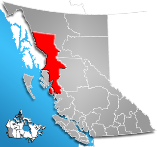
The Regional District of Kitimat-Stikine is a type of local government administration in northwestern British Columbia, Canada. As of the Canada 2001 Census it had a population of 40,876 living on a land area of 91,910.63 km². Its administrative offices are in the city of Terrace. The next-largest municipality in the regional district is the District Municipality of Kitimat. The other incorporated municipalities in the regional district are the Village of Hazelton, the District of New Hazelton and the District of Stewart. Unincorporated communities are many, most of them Indian Reserves which are not part of the governmental system of the regional district, which has limited powers relating mostly to municipal-type services. The remote settlement of Dease Lake, formerly in the Stikine Region, was added to the regional district on December 1, 2007.
Central Coast Regional District is a regional district in British Columbia, Canada. It has a total land area of 24,559.5 km². When it was created in 1968, it was named Ocean Falls Regional District, after the then-largest town in the region, the company town of Ocean Falls, which has since become a ghost town. The district name was confirmed in 1974, but changed to Central Coast Regional District in 1976.
The Quesnel Highland is a geographic area in the Central Interior of the Canadian province of British Columbia. As defined by BC government geographer in Landforms of British Columbia, an account and analysis of British Columbia geography that is often cited as authoritative, the Highland is a complex of upland hill and plateau areas forming and defined as being the buffer between the Cariboo Plateau and the Cariboo Mountains, as a sort of highland foothills along the eastern edge of the Interior Plateau running southeast from a certain point southeast of the city of Prince George to the Mahood Lake area at the southeast corner of the Cariboo. Beyond Mahood Lake lies another separately classified area dubbed by Holland the Shuswap Highland which spans similar terrain across the North Thompson and Shuswap Lake-Adams River drainage basins, forming a similar upland-area buffer between the Thompson Plateau and the Monashee Mountains. A third area, the Okanagan Highland, extends from the southern end of the Shuswap Highland in the area of Vernon and Enderby in the northern Okanagan region into Washington State, and also abuts the Monashee Mountains.

The Comox Valley Regional District is a regional district in British Columbia, Canada. It was created on February 15, 2008, encompassing the southeastern portions of the former Regional District of Comox-Strathcona, and centered about the Comox Valley. The partition left the new Comox Valley Regional District with only 8.4 percent of the former Comox-Strathcona's land area, but 57.9 percent of its population. The CVRD covers an area of 2,425 square kilometres, of which 1,725 square kilometres is land, and serves a population of 63,538 according to the 2011 Census. The district borders the Strathcona Regional District to the northwest, the Alberni-Clayoquot Regional District to the southwest, and the Regional District of Nanaimo to the southeast, as well as the Powell River Regional District along the Strait of Georgia to the east.
The Little River is a 35 km river in the Cariboo region of British Columbia, Canada, rising in the Cariboo Mountains north of the North Arm of Quesnel Lake and running roughly westwards to enter Cariboo Lake conjointly with the upper Cariboo River.