
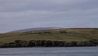
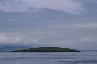
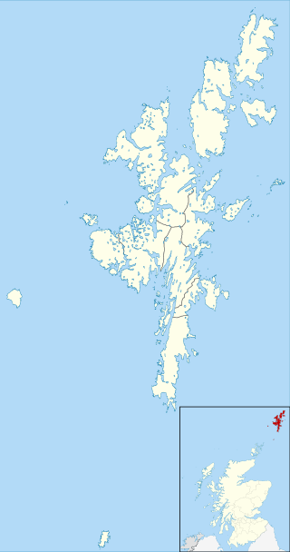
Little Roe is an island in Yell Sound in the Shetland Islands
Little Roe is an island in Yell Sound in the Shetland Islands
The island's name is Norse in origin, from Rauðey Litla, meaning "small red island" in contradistinction to Muckle Roe, which is not nearby, but in St Magnus Bay.
In 1841, eleven people lived here, all in the same house. [1]
A light beacon has been built on the island.
The island's name derives from its red granite. It is at 60°29′54″N1°16′06″W / 60.4982°N 1.2682°W , due east of the Northmavine at the entrance to Sullom Voe. [2] Lamba is due north, and Uynarey, Brother Isle and Bigga between it and Yell
Otters occasionally visit here, and puffins and storm petrels also nest here.
Yell is one of the North Isles of Shetland, Scotland. In the 2011 census it had a usually resident population of 966. It is the second largest island in Shetland after the Mainland with an area of 82 square miles (212 km2), and is the third most populous in the archipelago, after the Mainland and Whalsay.

Fetlar is one of the North Isles of Shetland, Scotland, with a usually resident population of 61 at the time of the 2011 census. Its main settlement is Houbie on the south coast, home to the Fetlar Interpretive Centre. Other settlements include Aith, Funzie, Herra and Tresta. Fetlar is the fourth-largest island of Shetland and has an area of just over 4,000 ha.

Muckle Roe is an island in Shetland, Scotland, in St. Magnus Bay, to the west of Mainland. It has a population of around 130 people, who mainly croft and live in the south east of the island.
Papa Little is an island in St Magnus Bay, Shetland, Scotland.

Brother Isle is a small, uninhabited island in Shetland, Scotland. It lies between the islands of Yell and Shetland Mainland. It is 40 hectares in size.

Linga is a very small uninhabited island in the Bluemull Sound, Shetland, Scotland. It is one of many islands in Shetland called Linga. It has an area of 45 ha and is 26m at its highest point.

Samphrey is an uninhabited island in the Shetland Islands, Scotland. One of Fair Isle's old names is "Friðarey" which is of similar origin.

Lamba is an uninhabited island in Yell Sound in Shetland. It lies 1.5 km (0.93 mi) north of the entrance to the Sullom Voe inlet and 1.4 kilometres (0.87 mi) east of the Mainland coastline near Ollaberry. Rising 35 metres above sea level, it has an area of 43 hectares (0.17 sq mi). Its main features are a 27m high light marking the entrance to Sullom Voe, and an adjacent communications mast.
Bigga is an uninhabited island in the Yell Sound between the Mainland and Yell in Shetland, Scotland.
Linga is a small, uninhabited island, 1 km (0.62 mi) east of Muckle Roe in the Shetland Islands. The island is roughly circular in shape and its highest elevation is 69 metres (226 ft). Its area is 70 hectares (0.27 sq mi).
Uynarey is one of the Shetland islands in Yell Sound, just to the north of Bigga, and east of Brother Island. It is an RSPB reserve. The name comes from the Norse for "venerated island", and this may reflect a Culdee connection.

Haaf Gruney is a small island in the north east of the Shetland Islands.

Orfasay is one of the Shetland Islands.

Gloup Holm is an islet in the Shetland Islands, lying to the north of Yell.

Yell Sound is the strait running between Yell and Mainland, Shetland, Scotland. It is the boundary between the Mainland and the North Isles and it contains many small islands. Sullom Voe, on the shores of which is a substantial oil terminal, is an arm of Yell Sound.
Sandsting is a parish in the West Mainland of Shetland, Scotland, forming a southern arm of the Walls Peninsula. After the parish of Aithsting was annexed into Sandsting in the sixteenth century, it became known as Sandsting and Aithsting parish.

Ollaberry is a village on Mainland, Shetland, Scotland on the west shore of Yell Sound, 10.9 miles (17.5 km) north by road from Brae. Ollaberry Churchyard contains a Listed B monument, sculpted by John Forbes in 1754. Ollaberry Primary School was established in 1873.
Delting is a civil parish and community council area on Mainland, Shetland, Scotland. It includes the Sullom Voe oil terminal and its main settlements are Brae, Mossbank and Voe.
| | This Shetland location article is a stub. You can help Wikipedia by expanding it. |