Related Research Articles

Kemper County is a county located on the central eastern border of the U.S. state of Mississippi. As of the 2020 census, the population was 8,988. Its county seat is De Kalb. The county is named in honor of Reuben Kemper.
De Kalb is a town in and the county seat of Kemper County, Mississippi, United States. The population was 1,164 at the 2010 census. De Kalb is named after General Johann de Kalb, a Franconian-French military officer who served as a major general in the Continental Army during the American Revolutionary War.

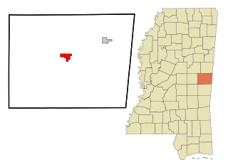
Scooba is a town in Kemper County, Mississippi, United States. The population was 732 as of the 2010 Census.

The Tennessee–Tombigbee Waterway is a 234-mile (377 km) artificial U.S. waterway built in the 20th century from the Tennessee River to the junction of the Black Warrior-Tombigbee River system near Demopolis, Alabama. The Tennessee–Tombigbee Waterway links commercial navigation from the nation's midsection to the Gulf of Mexico. The major features of the waterway are 234 miles (377 km) of navigation channels, a 175-foot-deep (53 m) cut between the watersheds of the Tombigbee and Tennessee rivers, and ten locks and dams. The locks are 9 by 110 by 600 feet, the same dimension as those on the Mississippi above Lock and Dam 26 at Alton, Illinois. Under construction for 12 years by the U.S. Army Corps of Engineers, the Tennessee–Tombigbee Waterway was completed in December 1984 at a total cost of nearly $2 billion.

The Chunky River is a short tributary of the Chickasawhay River in east-central Mississippi. Via the Chickasawhay, it is part of the watershed of the Pascagoula River, which flows into the Gulf of Mexico.
Cedar Creek may refer to several small streams in the U.S. state of Michigan:
Alamuchee Creek is a stream in the U.S. states of Alabama and Mississippi. It is a tributary to the Sucarnoochee River.
Archusa Creek is a stream in the U.S. state of Mississippi. It is a tributary to the Chickasawhay River.
Bogue Statinea is a stream in the U.S. state of Mississippi.
Chuquatonchee Creek is a stream in Chickasaw, Clay and Pontotoc counties in the U.S. state of Mississippi. It is a tributary to Tibbee Creek.
Kinterbish Creek is a stream in the U.S. states of Alabama and Mississippi. It is a tributary to the Tombigbee River.
Okatibbee Creek is a stream in the U.S. state of Mississippi.
Pushacoona Creek is a stream in the U.S. state of Mississippi.
Big Scooba Creek is a stream in the U.S. state of Mississippi.
Flat Scooba Creek is a stream in the U.S. state of Mississippi.
Souenlovie Creek is a stream in the U.S. state of Mississippi.
Sowashee Creek is a stream in the U.S. state of Mississippi.
Tallachula Creek is a stream in the U.S. state of Mississippi.
Tallahatta Creek is a stream in the U.S. state of Mississippi.
Toomsuba Creek is a stream in the U.S. states of Alabama and Mississippi.
References
- ↑ U.S. Geological Survey Geographic Names Information System: Little Scooba Creek
- ↑ Baca, Keith A. (2007). Native American Place Names in Mississippi. University Press of Mississippi. p. 91. ISBN 978-1-60473-483-6.
Coordinates: 32°47′47″N88°25′56″W / 32.7965207°N 88.4322586°W