
Gunnison is the county seat and the most populous municipality of Gunnison County, Colorado, United States. As of the 2010 census, the city had a population of 5,854. It was named in honor of John W. Gunnison, a United States Army officer who surveyed for the transcontinental railroad in 1853. Gunnison is a home rule municipality which reserves the right to choose how it is governed.

The Town of Marble is a Statutory Town in Gunnison County, Colorado, United States. The town population was 131 at the 2010 United States Census.

Black Canyon of the Gunnison National Park is an American national park located in western Colorado and managed by the National Park Service. There are two primary entrances to the park: the south rim entrance is located 15 miles (24 km) east of Montrose, while the north rim entrance is 11 miles (18 km) south of Crawford and is closed in the winter. The park contains 12 miles (19 km) of the 48-mile (77 km) long Black Canyon of the Gunnison River. The national park itself contains the deepest and most dramatic section of the canyon, but the canyon continues upstream into Curecanti National Recreation Area and downstream into Gunnison Gorge National Conservation Area. The canyon's name owes itself to the fact that parts of the gorge only receive 33 minutes of sunlight a day, according to Images of America: The Black Canyon of the Gunnison. In the book, author Duane Vandenbusche states, "Several canyons of the American West are longer and some are deeper, but none combines the depth, sheerness, narrowness, darkness, and dread of the Black Canyon."

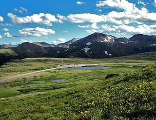
The Western Slope refers to a region of the state of Colorado incorporating everything in the state west of the Continental Divide. Bodies of water west of the Divide flow toward the Pacific Ocean. Water that falls and flows east of the Divide heads east. The Western Slope encompasses about 33% of the state, but has just 10% of the state's residents. The eastern part of the state, including the San Luis Valley and the Front Range is the more populous portion of the state.

Great Sand Dunes National Park and Preserve is an American national park that conserves an area of large sand dunes up to 750 feet (229 m) tall on the eastern edge of the San Luis Valley, and an adjacent national preserve in the Sangre de Cristo Range, in south-central Colorado, United States. The park was originally designated Great Sand Dunes National Monument on March 17, 1932, by President Herbert Hoover. The original boundaries protected an area of 35,528 acres. A boundary change and redesignation as a national park and preserve was authorized on November 22, 2000, and then established by an act of Congress on September 24, 2004. The park encompasses 107,342 acres while the preserve protects an additional 41,686 acres for a total of 149,028 acres. The recreational visitor total was 527,546 in 2019.

The Crystal River is a tributary of the Roaring Fork River, approximately 40 mi (64 km) long, in western Colorado in the United States. It drains a glacial valley, called the Coal Basin, south of Carbondale which was historically known as a center of coal mining in southwestern Colorado. It rises in northern Gunnison County in the Elk Mountains on the north side of Schofield Pass, passing through the ghost town of Crystal City, still inhabited by a few summer residents. It then flows north past Marble, then into Pitkin County past Redstone. It joins the Roaring Fork below Carbondale. State Highway 133 follows the river along much of its route north of Marble.
Independence Pass, originally known as Hunter Pass, is a high mountain pass in central Colorado, United States. It is at elevation 12,095 ft (3,687 m) on the Continental Divide in the Sawatch Range of the Rocky Mountains. The pass is midway between Aspen and Twin Lakes, on the border between Pitkin and Lake counties.

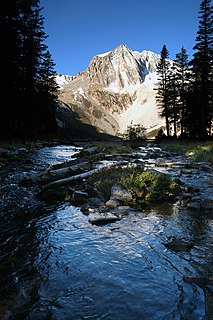
The Elk Mountains are a high, rugged mountain range in the Rocky Mountains of west-central Colorado in the United States. The mountains sit on the western side of the Continental Divide, largely in southern Pitkin and northern Gunnison counties, in the area southwest of Aspen, south of the Roaring Fork River valley, and east of the Crystal River. The range sits west of the Sawatch Range and northeast of the West Elk Mountains. Much of the range is located within the White River National Forest and the Gunnison National Forest, as well as the Maroon Bells-Snowmass Wilderness and Raggeds Wilderness. The Elk Mountains rise nearly 9,000 ft. above the Roaring Fork Valley to the north.

Snowmass Mountain is a fourteen thousand foot tall mountain in the U.S. state of Colorado, and is the thirty-fourth highest mountain peak in the state. Located in the Elk Mountains, within the Maroon Bells-Snowmass Wilderness of the White River National Forest, it lies along the border between the Pitkin and Gunnison counties, west of Aspen and southwest of the town of Snowmass Village.

Curecanti National Recreation Area is a National Park Service unit located on the Gunnison River in western Colorado. Established in 1965, Curecanti is responsible for developing and managing recreational facilities on three reservoirs, Blue Mesa Reservoir, Morrow Point Reservoir and Crystal Reservoir, constructed on the upper Gunnison River in the 1960s by the U.S. Bureau of Reclamation to better utilize the vital waters of the Colorado River and its major tributaries. A popular destination for boating and fishing, Curecanti offers visitors two marinas, traditional and group campgrounds, hiking trails, boat launches, and boat-in campsites. The state's premiere lake trout and Kokanee salmon fisheries, Curecanti is a popular destination for boating and fishing, and is also a popular area for ice-fishing in the winter months.

The Collegiate Peaks Wilderness is a 168,000-acre (680 km2) area located in central Colorado between Leadville and Buena Vista to the east and Aspen to the west and Crested Butte to the southwest. Most of the area is in the San Isabel and Gunnison National Forests, with a smaller area in the White River National Forest southeast of Aspen. Most of the area is in northwest Chaffee County with smaller portions in Gunnison, Pitkin, and Lake counties.

White River National Forest is a National Forest in northwest Colorado. It is named after the White River that passes through its northern section. It is the most visited National Forest in the United States, primarily from users of the twelve ski areas within its boundaries.
The Maroon Bells are two peaks in the Elk Mountains, Maroon Peak and North Maroon Peak, separated by about half a kilometer. The mountains are on the border between Pitkin County and Gunnison County, Colorado, United States, about 12 miles (19 km) southwest of Aspen. Both peaks are fourteeners. Maroon Peak, at 14,163 feet (4317 m), is the 27th highest peak in Colorado. North Maroon Peak, at 14,019 feet (4273 m), is the 50th highest. The view of the Maroon Bells to the southwest from the Maroon Creek valley is very heavily photographed. The peaks are located in the Maroon Bells–Snowmass Wilderness of White River National Forest. Maroon Bells-Snowmass Wilderness was one of five areas in Colorado designated as wilderness in the original Wilderness Act of 1964. The Wilderness area surrounds the extremely popular Maroon Bells Scenic Area, which is a major access point for Wilderness travel.

The Hualapai Mountains, are a mountain range in Mohave County, near Kingman in Arizona. "Hualapai" means "People of the tall Pines" in the Hualapai language.

Crystal is a ghost town on the upper Crystal River in Gunnison County, Colorado, United States. It is located in the Elk Mountains along a four-wheel-drive road 6 miles (9.7 km) east of Marble and 20 miles (32 km) northwest of Crested Butte. Crystal was a mining camp established in 1881 and after several decades of robust existence, was all but abandoned by 1917. Many buildings still stand in Crystal, but its few residents live there only in the summer.

Blue Mesa Reservoir is an artificial reservoir located on the upper reaches of the Gunnison River in Gunnison County, Colorado. The largest lake located entirely within the state, Blue Mesa Reservoir was created by the construction of Blue Mesa Dam, a 390-foot tall earthen fill dam constructed on the Gunnison by the U.S. Bureau of Reclamation in 1966 for the generation of hydroelectric power. Managed as part of the Curecanti National Recreation Area, a unit of the National Park Service, Blue Mesa Reservoir is the largest lake trout and Kokanee salmon fishery in Colorado.
Snowmass Peak in the U.S. state of Colorado dominates the view from Snowmass Lake. It is often mistaken for Snowmass Mountain, the thirty-fourth highest mountain peak in the state, as well as for Hagerman Peak. Snowmass Peak is not really a peak but the lower end of Hagerman Peak's east ridge. Natural forced perspective causes the optical illusion that Snowmass Peak is higher than Hagerman Peak though it is actually 221 ft shorter than Hagerman's summit. This illusion combined with its striking rise behind Snowmass Lake justifies it being a named point on USGS topographical maps. It is located in the Elk Mountains, within the Maroon Bells-Snowmass Wilderness of the White River National Forest. It lies along the border between Pitkin and Gunnison counties, west of Aspen and southwest of the town of Snowmass Village.

Hart Mountain National Antelope Refuge is a National Wildlife Refuge on Hart Mountain in southeastern Oregon, which protects more than 422 square miles (1,090 km2) and more than 300 species of wildlife, including pronghorn, bighorn sheep, mule deer, sage grouse, and Great Basin redband trout. The refuge, created in 1936 as a range for remnant herds of pronghorn, spans habitats ranging from high desert to shallow playa lakes, and is among the largest wildlife habitats containing no domestic livestock.

The Foot Hills State Forest is a state forest located in Cass, and Hubbard counties, Minnesota. The forest is a popular recreation spot due to its proximity to the greater Minneapolis – Saint Paul metropolitan area.

Treasure Mountain, elevation 13,535 ft (4,125 m), is a summit in the Elk Mountains of western Colorado. The mountain is in the Raggeds Wilderness southeast of Marble. The massif has been the site of marble mining and a legend of lost French gold.


