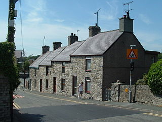
Pentraeth is a village and community on the island of Anglesey, North Wales, at grid reference SH523786. The Royal Mail postcode begins LL75. The community population taken at the 2011 census was 1,178. The village itself having a population of 557.

Din Lligwy hut circle is an ancient village site near the east coast of Anglesey, close to the village of Moelfre, North Wales.

Moelfre ( ) is a village, a community and, until 2012, an electoral ward on the north-east coast of the Isle of Anglesey in Wales. The community area covers the village and harbour, and several smaller, dispersed settlements. It includes six scheduled Iron Age hut groups and many other sites of archaeological interest. The harbour was formerly a local fishing port; a lifeboat station has been based here since 1854. Among many shipwrecks off the coast was that of the Royal Charter in 1859. Near the modernised lifeboat station is the RNLI Seawatch Centre. The coastline includes a rocky headland north of the village and a large sandy beach at Lligwy Bay, both traversed by the Anglesey Coastal Path. The 2011 census measured the village population as 710. It was estimated at 614 in 2019.
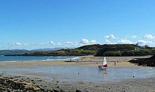
Red Wharf Bay, also known as Traeth Coch, is a village and a wide sandy bay in the Anglesey Area of Outstanding Natural Beauty on the east coast of the island of Anglesey in Wales. The bay lies between the villages of Pentraeth and Benllech. It is also close to Castell Mawr Rock, thought to be the site of an Iron Age fort.

A fishing weir, fish weir, fishgarth or kiddle is an obstruction placed in tidal waters, or wholly or partially across a river, to direct the passage of, or trap fish. A weir may be used to trap marine fish in the intertidal zone as the tide recedes, fish such as salmon as they attempt to swim upstream to breed in a river, or eels as they migrate downstream. Alternatively, fish weirs can be used to channel fish to a particular location, such as to a fish ladder. Weirs were traditionally built from wood or stones. The use of fishing weirs as fish traps probably dates back prior to the emergence of modern humans, and have since been used by many societies around the world.

Rhosneigr is a village in the south-west of Anglesey, north Wales. It is situated on the A4080 road some 10 km south-east of Holyhead, and is on the Anglesey Coastal Path. From the clock at the centre of the village can be seen RAF Valley and Mynydd Twr. The major towns of Holyhead and Llangefni and the city of Bangor are all within easy travelling distance. It is the most expensive place to live in Anglesey in terms of house prices.
Dulas Bay is a small bay on the north east coast of Anglesey, north Wales, forming the boundary between Llaneilian and Moelfre communities. The bay is bordered by three beaches.
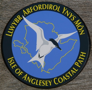
The Anglesey Coastal Path is a 200-kilometre (124 mi) long-distance footpath around the island of Anglesey in North Wales. The route is part of the Wales Coast Path.
Brynrefail is a small village in Gwynedd, Wales.

Lligwy Burial Chamber is a Neolithic burial chamber in Lligwy, near the east coast of Anglesey, Wales, United Kingdom. It consists of a circle of upright stones, made into a low chamber by a very large roof slab estimated at 25 tonnes. Excavation in 1909 found the remains of some 15 to 30 people, and pottery suggesting a late Neolithic date. Close to the village of Moelfre, the site is within a few metres of the road, where there is room to leave a single car for short periods.

Capel Lligwy is a ruined chapel near Rhos Lligwy in Anglesey, north Wales, dating back to the first half of the 12th century. The chapel's original purpose is unknown, but it might have been used as a memorial chapel or in connection with a local royal court, or as a chapel of ease in a large parish with a growing population. It was used for a time until the early 18th century as a private place of worship for a nearby house, then later fell into disrepair. The walls still remain, with some traces of render on them internally, but there is no roof.

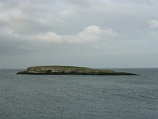
Llaneilian is a village and community in Anglesey, Wales. It is located in the north east of the island, 2.2 miles (3.5 km) east of Amlwch, 16.5 miles (26.6 km) north west of Menai Bridge and 12.5 miles (20.1 km) north of Llangefni. The community includes the villages and hamlets of Dulas, Llaneilian, Pengorffwysfa, Cerrig Man and Penysarn, Gadfa and Nebo, and at the 2001 census had a population of 1,192, decreasing slightly to 1,186 at the 2011 Census. The parish is crowned by its hill, Mynydd Eilian, a HuMP, popular with walkers and ramblers, and its beach, Traeth Eilian, which is popular with holidaymakers and for watersport activities. At the north easternmost point is Point Lynas,, while Ynys Dulas lies off the North East coast of the island, east of Dulas Bay.

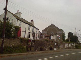
Marian-glas or Marianglas is a small village and post town in Anglesey, north-west Wales. It lies between the larger villages of Moelfre and Benllech and just off the A5025. There is a large caravan park on the edge of the village and several camp sites. There is a church and pub but no shop. It has a memorial to those killed in the two world wars, including a list of 17 seamen from the Merchant Navy.
Llaneugrad is a community in Anglesey, Wales. It is located on the east coast of the island, 7.2 miles (11.6 km) south east of Amlwch, 9.8 miles (15.8 km) north west of Menai Bridge and 6.7 miles (10.8 km) north east of Llangefni, and includes the village of Marian-glas. At the 2001 census the community had a population of 273.

St Michael's Church is the parish church of Penrhoslligwy, a village near Moelfre in the north-east of the island of Anglesey, in Gwynedd, Wales. With datable components from around 1400, the building is listed at Grade II* and was restored in 1865.

The Menai Strait fish weirs are historically important fishing traps used in the fast-flowing tidal waters of the Menai Strait, which separates Anglesey from the rest of North Wales. The strait was particularly well suited to utilising fish weirs. The tidal waters pull huge volumes of water past the coastline with every tide, and the weirs and traps enabled fish to be concentrated into small holding areas from which they can be readily caught. Such methods are thought to have been used from earliest times, but the submerged and standing remains along both the Anglesey and Gwynedd coasts are from medieval and post-medieval periods, and in some cases were still in use into the 20th century.

Llanddona fish weir is a post-medieval fish trap sited in Llanddona, on the Isle of Anglesey. The fish weir is a scheduled monument.

Church Bay is a settlement on the north-west coast of Anglesey, Wales, United Kingdom, about a mile and a half north-west of the village of Llanfaethlu. The bay shores are rocky but there is also a sandy beach which is popular with visitors. There are a handful of houses near the beach. The Anglesey Coastal Path runs along the cliff tops. There are records of the Swttan settlement going back to the reign of King Henry VIII, but there has probably been a settlement there for many centuries before this. Most of the properties are holiday homes for rent. Amenities include a cafe and a small museum based in a preserved 17th-century thatched cottage. This cottage's position could indicate that there has been a dwelling on this site since Neolithic times. The cottage won the Rural Wales Award from the Campaign for the Protection of Rural Wales (CPRW) in 2003.