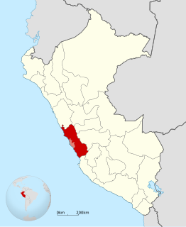
The Department of Lima is located in the central coast of the country, its regional seat is Huacho. Lima Province, which contains the city of Lima, the country's capital, is located west of the Department of Lima; this province is autonomous and not under the jurisdiction of the Regional Government.
Miraflores District is one of thirty-three districts of the province Yauyos in Peru.
Tomas District is one of thirty-three districts of the Yauyos Province in Peru.
The Nor Yauyos-Cochas Landscape Reserve is a protected area in Peru located in the Lima Region, Yauyos Province and in the Junín Region, Jauja Province. It lies with the Peruvian Yungas and Central Andean wet puna ecoregions.
Chuspicocha is a lake in Peru located in the Lima Region, Yauyos Province, Tanta District. It is situated at a height of about 4,625 metres (15,174 ft), about 1.02 km long and 0.4 km at its widest point. Chuspicocha lies south of the Pariacaca mountain range and Paucarcocha and north of Ticllacocha and Piscococha, near the village of Tanta.

Tunshu is a 5,660-metre-high (18,570 ft) mountain in the Pariacaca mountain range in the Andes of Peru. It is located in the Junín Region, Jauja Province, Canchayllo District and in the Yauli Province, Suitucancha District. Tunshu lies north of Pariacaca and northwest of Tukumach'ay and the lake named Qarwaqucha. It is situated on the northern border of the Nor Yauyos-Cochas Landscape Reserve.
Ticllacocha is a lake in Peru located in the Lima Region, Yauyos Province, Tanta District. It is situated at a height of about 4,475 metres (14,682 ft), south of the lakes Paucarcocha, Chuspicocha and Piscococha and northwest of the mountains Ticlla and Huayna Cotoni.
Piscococha is a lake in Peru located in the Lima Region, Yauyos Province, Tanta District. Piscococha is situated at a height of about 4,484 metres (14,711 ft), south of the lakes Paucarcocha and Chuspicocha and northeast of the lake Ticllacocha.
Lake Mullucocha is a lake in Peru located in the Lima Region, Yauyos Province, Tanta District. Mullucocha, situated at a height of about 4,286 metres (14,062 ft), lies southeast of the Pariacaca mountain range, east of P'itiqucha and northeast of Paucarcocha.
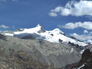
Ticlla or Qutuni, also called Tiklla or Tiqlla, is a 5,897-metre-high (19,347 ft) mountain in the Cordillera Central in the Andes of Peru. Strictly speaking the popular name Ticlla refers to a group of peaks of the Qutuni-Ticlla cirque. The highest mountain of the massif is named Qutuni. It lies in a sub-range of the Cordillera Central named Pichqa Waqra.

Wamp'una is a mountain in the Cordillera Central in the Andes of Peru, about 5,000 metres (16,404 ft) high. It contains one of the highest surveyed caves in the word, Qaqa Mach'ay. Wamp'una is located in the Lima Region, Yauyos Province, on the border of the districts of Huantán and Laraos. It lies southwest of T'uruyuq, southeast of the lake named Pumaqucha. It is situated on the southern border of the Nor Yauyos-Cochas Landscape Reserve.
Huayna Cotoni or Wayna Qutuni(Aymara wayna young, bachelor, qutu heap, pile, -ni a suffix to indicate ownership, Qutuni a neighboring mountain, "young Qutuni", Hispanicized spellings Huayna Cotoni, Huaynacotoni, Huaynacutuni) is a mountain in the Cordillera Central in the Andes of Peru, about 5,463 metres (17,923 ft) high. It is located in the Lima Region, Yauyos Province, on the border of the districts of Ayaviri, Quinches and Tanta. Huayna Cotoni is in a sub-range of the Cordillera Central named Pichqa Waqra on the southern border of the Nor Yauyos-Cochas Landscape Reserve. It lies between the lakes named Tikllaqucha in the north and Huayna Cotoni in the south, southwest of the peak of Qutuni and south of Aqupallqa.
Wiraqucha is a mountain in the Andes of Peru, about 4,600 metres (15,092 ft) high. It is located in the Junín Region, Jauja Province, Canchayllo District. Wiraqucha lies east of the lakes named Llaksaqucha, Mankhaqucha and Chakip'aki (Chaquipaque), south of Challwaqucha and north of the mountain named Chakip'aki. It is situated on the eastern border of the Nor Yauyos-Cochas Landscape Reserve.

Lake Cochabamba is a lake in Peru located in the Lima Region, Yauyos Province, Laraos District. It is situated at a height of about 3,373 m (11,066 ft) near Laraos within the Nor Yauyos-Cochas Landscape Reserve.
Corihuasi is a mountain in the Pariacaca or Huarochiri mountain range in the Andes of Peru, about 5,200 metres (17,060 ft) high. It is located in the Junín Region, Jauja Province, Canchayllo District, and in the Lima Region, Huarochiri Province, Quinti District. Corihuasi lies between the mountains Colquepucro in the north-west and Pariacaca in the south-east. It is situated on the western border of the Nor Yauyos-Cochas Landscape Reserve.
Pachanqutu or Phanchaqutu is a mountain in the Paryaqaqa or Waruchiri mountain range in the Andes of Peru, about 5,400 metres (17,717 ft) high. It is situated in the Lima Region, Huarochirí Province, San Mateo District, and in the Junín Region, Yauli Province, Suitucancha District. It lieson the western border of the Nor Yauyos-Cochas Landscape Reserve. Pachanqutu lies near Tunshu, southeast of Paka (Paca), south of Sullcon and Americo, and west of the branch of Antachaire.
Runchu is a 5,165-metre-high (16,946 ft) mountain in the Cordillera Central in the Andes of Peru. It is located in the Lima Region, Yauyos Province, on the border of the districts of San Joaquín and Tanta. Runchu lies northwest of Tikllaqucha. It is situated on the western border of the Nor Yauyos-Cochas Landscape Reserve.
Suyruqucha is a mountain in the Paryaqaqa or Waruchiri mountain range in the Andes of Peru, about 5,500 metres (18,045 ft) high. It is located in the Junín Region, Jauja Province, Canchayllo District, in the Yauli Province, Suitucancha District, and in the Lima Region, Huarochiri Province, Quinti District. It lies on the western border of the Nor Yauyos-Cochas Landscape Reserve. It is situated northwest of Qullqip'ukru. Wararayuq lies west of it.
Parya Chaka is a mountain in the south of the Paryaqaqa or Waruchiri mountain range in the Andes of Peru, about 5,000 m (16,404 ft) high. It is also the name of a lake near the mountain. The mountain is located in the Lima Region, Huarochirí Province, Quinti District, and in the Yauyos Province, Tanta District. It is situated southwest of Paryaqaqa. It is situated within the borders of the Nor Yauyos-Cochas Landscape Reserve.
Uqsha is a mountain in the Cordillera Central in the Andes of Peru, about 4,800 m (15,748 ft) high. It is located in the Lima Region, Huarochirí Province, Quinti District, and in the Yauyos Province, Tanta District, southwest of the lake named P'itiqucha. Uqsha lies northeast of Waswa Punta and southeast of Hatun Ukru. It is situated on the western border of the Nor Yauyos-Cochas Landscape Reserve.


