
Snowdonia, or Eryri, is a mountainous region and national park in North Wales. It contains all 15 mountains in Wales over 3000 feet high, including the country's highest, Snowdon, which is 1,085 metres (3,560 ft) tall. These peaks are all part of the Snowdon, Glyderau, and Carneddau ranges in the north of the region. The shorter Moelwynion and Moel Hebog ranges lie immediately to the south.

Snowdon, or Yr Wyddfa, is a mountain in the Snowdonia region of North Wales. It has an elevation of 1,085 metres (3,560 ft) above sea level, which makes it both the highest mountain in Wales and the highest in the British Isles south of the Scottish Highlands. Snowdon is designated a national nature reserve for its rare flora and fauna, and is located within Snowdonia National Park.

Bala Lake is a large freshwater glacial lake in Gwynedd, Wales. The River Dee, which has its source on the slopes of Dduallt in the mountains of Snowdonia, feeds the 3.7 miles (6.0 km) long by 0.5 miles (0.8 km) wide lake. It was the largest natural body of water in Wales even before its level was raised by Thomas Telford to provide water for the Ellesmere Canal.

Moel Hebog is a mountain in Snowdonia, north Wales which dominates the view west from the village of Beddgelert. It gives name to a whole range of peaks in the north-western corner of Snowdonia, which include the Nantlle Ridge and Mynydd Mawr.
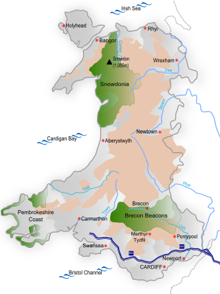
Wales is a country that is part of the United Kingdom and whose physical geography is characterised by a varied coastline and a largely upland interior. It is bordered by England to its east, the Irish Sea to its north and west, and the Bristol Channel to its south. It has a total area of 2,064,100 hectares and is about 170 mi (274 km) from north to south and at least 60 mi (97 km) wide. It comprises 8.35 percent of the land of the United Kingdom. It has a number of offshore islands, by far the largest of which is Anglesey. The mainland coastline, including Anglesey, is about 1,680 mi (2,704 km) in length. As of 2014, Wales had a population of about 3,092,000; Cardiff is the capital and largest city and is situated in the urbanised area of South East Wales.

Pen-y-Gwryd is a pass at the head of Nantygwryd and Nant Cynnyd rivers close to the foot of Snowdon in Gwynedd, Wales. The area is located at the junction of the A4086 from Capel Curig to Llanberis and Caernarfon and the A498 from Beddgelert and Nant Gwynant about a mile from the head of the Llanberis Pass. It is close to the boundary with Conwy county borough in northern Snowdonia. The famous mountaineering hostelry, Pen-y-Gwryd Hotel, is located in the pass. It is also a mountain rescue post with links to the other rescue posts at Ogwen Cottage and Plas y Brenin.

Llyn Cwellyn is a reservoir in North Wales which supplies drinking water to parts of Gwynedd and Anglesey. It lies on the Afon Gwyrfai in Nant y Betws between Moel Eilio and Mynydd Mawr in the northern part of Snowdonia National Park. It has an area of 215 acres (0.87 km2), and is over 120 ft (37 m) deep. At the southern end is the small village of Rhyd Ddu.

Afon Glaslyn is a river in Gwynedd, north-west Wales. While not of great significance in terms of its length, it is one of Gwynedd's primary rivers, and has greatly influenced the landscape in which it flows.

Tal-y-llyn Lake,, also known as Talyllyn Lake and Llyn Myngul, is a large glacial ribbon lake in Gwynedd, North Wales. It is formed by a post-glacial massive landslip damming up the lake within the glaciated valley. The hamlet of Talyllyn lies at the west end of the lake.

Llyn Padarn is a glacially formed lake in Snowdonia, Gwynedd, north Wales, and is an example of a moraine dammed lake. The lake is approximately 2 miles (3.2 km) long and at its deepest point is 94 feet (29 m) deep, and is one of the largest natural lakes in Wales. At its south-eastern end it is linked to the neighbouring Llyn Peris. The busy village of Llanberis lies on the southern banks of the lake.
Llyn Crafnant is a lake that lies in a valley in Wales where the northern edge of the Gwydir Forest meets the lower slopes of the Carneddau mountains and, more specifically, the ridge of Cefn Cyfarwydd. The head of the valley offers a profile of crags which are silhouetted at sunset. The Forest Park guide (2002) states that "the is one of the most breathtaking views in all Snowdonia". The summits include Crimpiau 475 metres, and Craig Wen 548 metres which provide views to Moel Siabod and the Ogwen Valley, and Snowdon. Further up is Creigiau Gleision. At 63 acres (250,000 m2) it is the best part of a mile long, although it was clearly once much longer - its southern end shows the evidence of centuries of silting. Jehu's survey (see references) recorded a maximum depth of 71 ft (22 m).

Llyn Geirionydd lies in a valley in North Wales where the northern edge of the Gwydyr Forest meets the lower slopes of the Carneddau mountains. The lake is almost a mile long and covers an area of 45 acres (180,000 m2), but is never any deeper than 50 ft (15 m) according to Jehu's survey. The lake can be reached by car from Trefriw or Llanrwst in the Conwy valley, the lane passing through the hamlet of Llanrhychwyn, or from the road through the Gwydir Forest. Access is not particularly easy by either route, but this has not stopped the lake being the only one designated in Snowdonia to permit power boats and water skiing. Many visitors also walk to the lake from the village of Trefriw or from the neighbouring lake of Llyn Crafnant, which runs parallel to it, but a mile distant, the two being separated by Mynydd Deulyn, “mountain of the two lakes”.

Llyn Ogwen is a ribbon lake in north-west Wales. It lies alongside the A5 road between two mountain ranges of Snowdonia, the Carneddau and the Glyderau. Somewhat unusually, the county boundary at this point is drawn so that the lake itself lies in the county of Gwynedd, but all the surrounding land lies in Conwy County Borough.

Nant Gwynant is a valley in northern Wales. The A498 road descends 600 feet (180 m) into the valley in about two miles (3 km) from Pen-y-Gwryd; it follows the Nant Cynnyd, the Afon Glaslyn and alongside Llyn Gwynant, then beside the Nant Gwynant river to Llyn Dinas and passing below Dinas Emrys to Beddgelert. The road continues through the Aberglaslyn Pass to Porthmadog.

Tan-y-Bwlch lies in the Snowdonia National Park in North Wales and is primarily known as the location of Tan-y-Bwlch railway station, on the narrow gauge Ffestiniog Railway.

Porthdinllaen is a small coastal village on the Llŷn Peninsula in the Dwyfor area of Gwynedd, Wales, built on a small promontory, and historically in Caernarfonshire. It is near the larger village of Morfa Nefyn.
Yr Arddu is a large hill in Snowdonia, Wales. It lies approximately 2.5 km south east of the village of Beddgelert and just over 1 km from the rather more famous mountain Cnicht. It is a rugged hill with widespread rock outcrops and cliffs. A small lake, Llyn yr Arddu, is located on the flanks of the mountain. The recognised summit is at 388m to the South of the hill, but the highest point, named Cerrig-y-Myllt on only the most detailed UK Ordnance Survey mapping, is at 463m above the two small lakes to the North of the hill. The craggy nature of the hill is due to the presence of lavas and tuffs dating from the Ordovician period when Snowdonia was characterised by numerous volcanic eruptions; Yr Arddu is a particularly good location to see the record of Ordovician volcanism. The Yr Arddu Tuffs may be the earliest eruptive phase of the Lower Rhyolitic Tuff Formation.

Gallt y Wenallt is a subsidiary summit of Y Lliwedd in Snowdonia National Park, north Wales. It lies at the end of the north ridge. Its northern face is reputed to be the longest slope in Snowdonia, being close to 2000 ft. It is also the last nail in the "completist's" Snowdon Horseshoe.

Moel Emoel is a hill within the Snowdonia National Park in Gwynedd, North Wales.

The geology of Snowdonia National Park in North Wales is dominated by sedimentary and volcanic rocks from the Cambrian and Ordovician periods with intrusions of Ordovician and Silurian age. There are Silurian and Cenozoic sedimentary rocks on the park's margins. The succession was intensely faulted and folded during the Caledonian Orogeny. The region was uplifted as the North Atlantic Ocean opened during the Cenozoic. The current mountainous landscape arises from repeated glaciations during the Quaternary period.


