
Badenoch is a traditional district which today forms part of Badenoch and Strathspey, an area of Highland Council, in Scotland, bounded on the north by the Monadhliath Mountains, on the east by the Cairngorms and Braemar, on the south by Atholl and the Grampians, and on the west by Lochaber. The capital of Badenoch is Kingussie.

The Grampian Mountains is one of the three major mountain ranges in Scotland, that together occupy about half of Scotland. The other two ranges are the Northwest Highlands and the Southern Uplands. The Grampian range extends southwest to northeast between the Highland Boundary Fault and the Great Glen. The range includes many of the highest mountains in the British Isles, including Ben Nevis and Ben Macdui.
Loch Morar is a freshwater loch in Lochaber, Highland, Scotland. It is the fifth-largest loch by surface area in Scotland, at 26.7 km2 (10.3 sq mi), and the deepest freshwater body in the British Isles with a maximum depth of 310 m (1,017 ft). The loch was created by glacial action around 10,000 years ago, and has a surface elevation of 9 metres (30 ft) above sea level. It separates the traditional district of North Morar, from Arisaig and Moidart.

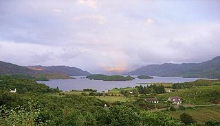
Loch Rannoch is a freshwater loch in Perth and Kinross, Scotland. It is over 15 kilometres (9.3 mi) long in a west–east direction with an average width of about 1.2 kilometres (0.75 mi), and is deepest at its eastern end, reaching a depth of 130 metres (440 ft). The River Tummel begins at its eastern end, where the small village of Kinloch Rannoch can be found, whilst the wild expanse of Rannoch Moor extends to the west of the loch. The area surrounding Loch Rannoch, along with Rannoch Moor itself, was formerly part of the native Caledonian Forest that stretched across much of Northern Scotland. Native forest is now largely absent from much of the area, due partly to logging, and partly to the climate becoming wetter, and Loch Rannoch is now largely surrounded by commercial forestry and open hillsides, although a small area remains at the Black Wood of Rannoch on the southern shore of the loch.

The Pass of Drumochter meaning simply 'high ridge' is the main mountain pass between the northern and southern central Scottish Highlands. The A9 road passes through here, as does the Highland Main Line, the railway between Inverness and the south of Scotland. The Sustrans National Cycle Route 7 between Glasgow and Inverness also runs through the pass.

Loch Tummel is a long, narrow loch, seven kilometres northwest of Pitlochry in the council area of Perth and Kinross, Scotland. It is fed and drained by the River Tummel, which flows into the River Tay about 13 km (8 mi) south-east of the Clunie Dam at the loch's eastern end.

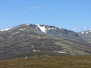
Ben Alder is the highest mountain in the remote area of the Scottish Highlands between Loch Ericht and Glen Spean. It rises to 1,148 metres (3,766 ft), making it the 25th highest Munro. The vast summit plateau is home of one of Britain's highest bodies of standing water, Lochan a' Garbh Coire.

The Monadhliath Mountains, or Monadh Liath, are a range of mountains in Scotland. Monadh Liath is Scottish Gaelic, and means "grey mountain range". Running in a northeast to southwest direction, it lies on the western side of Strathspey, to the west of the Cairngorms and to the south east of Loch Ness. Its southwestern limit is usually taken to be Corrieyairack Pass (763m) but similar uplands continue to Glen Roy and Spean Bridge. The range is within the Highland council area, and the south and east fringes are within the Cairngorms National Park. The high point of the range is Càrn Dearg, at 945 metres (3,100 ft), located 40 kilometres (25 mi) south of Inverness. This is one of four Munros in the Monadhliath, the others being A'Chailleach, Geal Chàrn, and Càrn Sgulain. The Monadhliath Mountains are designated a Special Area of Conservation (SAC).
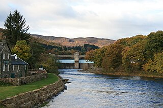
The Tummel hydro-electric power scheme is an interconnected network of dams, power stations, aqueducts and electric power transmission in the Grampian Mountains of Scotland. Roughly bounded by Dalwhinnie in the north, Rannoch Moor in the west and Pitlochry in the east it comprises a water catchment area of around 1,800 square kilometres and primary water storage at Loch Ericht, Loch Errochty, Loch Rannoch and Loch Tummel, in Perth and Kinross. Water, depending on where it originates and the path it takes, may pass through as many as five of the schemes nine power stations as it progresses from north-west to south-east. The scheme was constructed in the 1940s and 50s incorporating some earlier sites. It is managed by SSE plc.
Sgairneach Mhòr is a Scottish mountain which lies in a group of seven Munros near the summit of the Pass of Drumochter and are known as the Drumochter mountains or informerly as the “A9 Munros”. The mountain is situated 13 km SSW of Dalwhinnie and four km east of the large Loch Ericht.
A' Mharconaich is a mountain near Dalwhinnie in the Scottish Highlands. It is a Munro with a height of 975 metres (3,199 ft). It is in a group of mountains east of Loch Ericht and west of the A9 road and Pass of Drumochter, and are known accordingly as the Drumochter Hills. A' Mharconaich is just within the Cairngorms National Park although it is not part of the Cairngorms mountains.

Dunalastair Water is an entirely man made reservoir in Scotland which lies between Loch Rannoch and Loch Tummel in Strath Tummel in Perth and Kinross council area. The loch provides water power for the Tummel hydroelectricity power station and has the reputation as one of the best wild trout fishing locations in the United Kingdom.

Beinn a' Chuallaich is a Scottish hill, four kilometres northeast of the village of Kinloch Rannoch in the Perth and Kinross council area. It is part of the high ground between Strath Tummel and Glen Errochty.

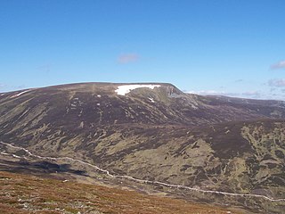
Beinn Udlamain is a Scottish mountain which stands just to the west of the summit of the Pass of Drumochter and east of Loch Ericht, some 30 km west-northwest of the village of Blair Atholl. The mountain’s summit stands on the border between the Highland and Perth and Kinross council areas.

The River Truim is a right bank tributary of the River Spey in the Scottish Highlands. Its headwaters meet to the north of the Pass of Drumochter and flow northwards as the Truim past the dam at the northern end of Loch Ericht and through the village of Dalwhinnie, highest village in the Scottish Highlands. The distillery at Dalwhinnie producing Dalwhinnie Single Malt is also the highest in Scotland. The waters of its most significant tributary, the Allt Cuaich, are diverted in part along an aqueduct to Loch Ericht. The river continues north-northeastwards down Glen Truim, over the Falls of Truim and on to meet the Spey 2.5 miles (4 km) southwest of Newtonmore. It is closely followed for almost its entire length by both the A9 road and the mainline railway from Perth to Inverness.

The River Garry is a major tributary of the River Tummel, itself a tributary of the River Tay, in the traditional county of Perthshire in the Scottish Highlands. It emerges from the northeastern end of Loch Garry (56.8193°N 4.2311°W), just to the southeast of the Pass of Drumochter, and flows southeastwards and eastwards down Glen Garry to the narrow Pass of Killiecrankie beyond which it joins the Tummel (56.7182°N 3.7790°W).
This article describes the geology of the Cairngorms National Park, an area in the Highlands of Scotland designated as a national park in 2003 and extended in 2010. The Cairngorms National Park extends across a much wider area than the Cairngorms massif itself and hence displays rather more varied geology.

Beinn Bheoil is a mountain in the Grampian Mountains of Scotland, located on the western shore of Loch Ericht in Highland.

Stob an Aonaich Mhoir is a remote mountain in the Grampian Mountains of Scotland. It lies in Perthshire, on the eastern shore of Loch Ericht.

Aonach Beag is a 1,116-metre (3,661 ft) mountain in the Highlands of Scotland in the remote area between Loch Ericht and Loch Laggan located about 4 kilometres (2.5 mi) northwest of Ben Alder. Its prominence is 99 metres (325 ft) with its parent peak, Geal-Charn, about 1 kilometre (0.62 mi) to the east. In Gaelic, Aonach Beag means "little ridge" despite it being a Munro. It should not be confused with the better-known Munro near Ben Nevis, also called Aonach Beag, about 30 kilometres (19 mi) to the west.

