
Balmoral Castle is a large estate house in Royal Deeside, Aberdeenshire, Scotland, owned by Queen Elizabeth II. It is near the village of Crathie, 6.2 miles (10 km) west of Ballater and 6.8 miles (11 km) east of Braemar.

The Highlands is a historic region of Scotland. Culturally, the Highlands and the Lowlands diverged from the later Middle Ages into the modern period, when Lowland Scots replaced Scottish Gaelic throughout most of the Lowlands. The term is also used for the area north and west of the Highland Boundary Fault, although the exact boundaries are not clearly defined, particularly to the east. The Great Glen divides the Grampian Mountains to the southeast from the Northwest Highlands. The Scottish Gaelic name of A' Ghàidhealtachd literally means "the place of the Gaels" and traditionally, from a Gaelic-speaking point of view, includes both the Western Isles and the Highlands.

Perthshire, officially the County of Perth, is a historic county and registration county in central Scotland. Geographically it extends from Strathmore in the east, to the Pass of Drumochter in the north, Rannoch Moor and Ben Lui in the west, and Aberfoyle in the south; it borders the counties of Inverness-shire and Aberdeenshire to the north, Angus to the east, Fife, Kinross-shire, Clackmannanshire, Stirlingshire and Dunbartonshire to the south and Argyllshire to the west. It was a local government county from 1890 to 1930.

Scotland is a well-developed tourist destination, with tourism generally being responsible for sustaining 200,000 jobs mainly in the service sector, with tourist spending averaging at £4bn per year. In 2013, for example, UK visitors made 18.5 million visits to Scotland, staying 64.5 million nights and spending £3.7bn. In contrast, overseas residents made 1.58 million visits to Scotland, staying 15 million nights and spending £806m. In terms of overseas visitors, those from the United States made up 24% of visits to Scotland, with the United States being the largest source of overseas visitors, and Germany (9%), France (8%), Canada (7%) and Australia (6%), following behind.

Pitlochry is a town in the county of Perthshire in Scotland, lying on the River Tummel. It is administered as part of the council area of Perth and Kinross, and has a population of 2,776, according to the 2011 census.

Loch Maree is a loch in Wester Ross in the Northwest Highlands of Scotland. At 21.7 km (13.46 mi) long and with a maximum width of 4 km (2.5 mi), it is the fourth largest freshwater loch in Scotland; it is the largest north of Loch Ness. Its surface area is 28.7 km2 (11.08 sq mi).
Ben Macdui is the second highest mountain in Scotland after Ben Nevis, and the highest in the Cairngorms National Park. The summit elevation is 1,309 meters AMSL. Ben Macdui lies on the southern edge of the Cairn Gorm plateau, on the boundary between the historic counties of Aberdeenshire and Banffshire.
Crínán of Dunkeld was the hereditary abbot of the monastery of Dunkeld, and perhaps the Mormaer of Atholl. Crínán was progenitor of the House of Dunkeld, the dynasty which would rule Scotland until the later 13th century. He was the son-in-law of one king, and the father of another.

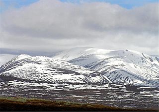
Lochnagar or Beinn Chìochan is a mountain in the Grampians of Scotland, located about five miles south of the River Dee near Balmoral. It is a popular hill with hillwalkers, and is a noted venue for summer and winter climbing.

Ben Lawers is the highest mountain in the southern part of the Scottish Highlands. It lies to the north of Loch Tay, and is the highest point of a long ridge that includes seven Munros. It is the highest peak in Perthshire, and is the tenth highest Munro in Scotland. Ben Lawers was long thought to be over 4,000 feet (1,219.2 m) in height; accurate measurement in the 1870s showed it to be some 17 feet (5.2 m) short of this figure.
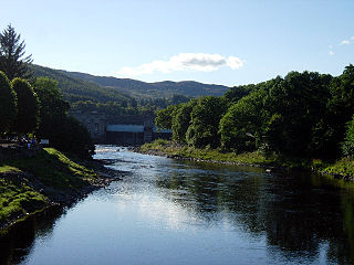
The River Tummel is a river in Perth and Kinross, Scotland. Water from the Tummel is used in the Tummel hydro-electric power scheme, operated by SSE.

Loch Tummel is a long, narrow loch, 7 km (4.3 mi) north west of Pitlochry in the council area of Perth and Kinross, Scotland. It is fed and drained by the River Tummel, which flows into the River Tay about 13 km (8.1 mi) south-east of the Clunie Dam at the loch's eastern end.

Dunkeld and Birnam is a community council area and UK Census locality in Perth and Kinross, Scotland, consisting of two villages on opposite banks of the River Tay: the historic cathedral "city" of Dunkeld on the north bank, and Birnam on the south bank. The two were first linked by a bridge built in 1809 by Thomas Telford. The two places lie close to the Highland Boundary Fault, which marks the geological boundary between the Highlands and the Lowlands, and are frequently described as the "Gateway to the Highlands" due to their position on the main road and rail lines north. Dunkeld and Birnam share a railway station, Dunkeld & Birnam, on the Highland Main Line, and are about 24 kilometres (15 mi) north of Perth on what is now the A9 road.

Breadalbane —from Scottish Gaelic Bràghad Albainn, "the upper part of Alba"—is a region of the southern/central Scottish Highlands, traditionally comprising the watershed of Loch Tay. The Breadalbane Hydro-Electric Scheme lies within the region.

Loch Loch is a remote freshwater loch, located in Glen Loch in Perth and Kinross, some 9.5 miles north of Pitlochry, Scotland and is within the Forest of Atholl.

Loch Kennard is freshwater loch located south-east of Aberfeldy, situated on Grandtully Hill in Perth and Kinross within Griffin Forest in Scotland.
Loch Skiach is a small freshwater loch in Perth and Kinross, Scotland, situated 4 miles southwest of Ballinluig.

Loch Moraig is a freshwater loch, located 2 miles northeast of Blair Atholl. Loch Moraig was an artificial loch, originally a Snipe marsh, that was dammed in the south, to create the current loch.

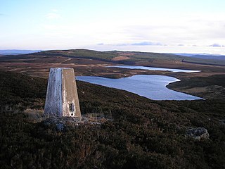
Loch Turret is a large freshwater reservoir on a north-east to south-west orientation, that is located at the head of Glen Turret and 5.39 miles northwest of Crieff in Perth and Kinross.


